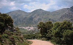
Villaluenga del Rosario
| Villaluenga del Rosario municipality | ||
|---|---|---|
| coat of arms | Map of Spain | |

|
|
|
| Basic data | ||
| Autonomous Community : | Andalusia | |
| Province : | Cadiz | |
| Comarca : | Sierra de Cadiz | |
| Coordinates | 36 ° 42 ′ N , 5 ° 23 ′ W | |
| Height : | 858 msnm | |
| Area : | 59.46 km² | |
| Residents : | 455 (Jan 1, 2019) | |
| Population density : | 7.65 inhabitants / km² | |
| Postal code : | 11611 | |
| Municipality number ( INE ): | 11040 | |
| administration | ||
| Website : | www.villaluengadelrosario.es | |
| Location of the municipality | ||

|
||
Villaluenga del Rosario (province of Cádiz) is a municipality in Andalusia ( Spain ), 870 m above sea level. d. M. is in the middle of the natural park "Sierra de Grazalema". This makes it the highest town in the province of Cádiz . The place is 80 km from Jerez de la Frontera and 118 km northeast of the provincial capital Cadiz . The place is a popular destination for hikers.
Attractions
- Iglesia San Miguel (a 16th century church with a Baroque baptistery)
- Bullring (with the special feature that it is not round, as usual, but square)
- Iglesia de El Salvador (built in 1772, burned out under Napoleonic occupation and now used as a cemetery)
- Sima del Republicano (a roughly 220 m deep crevasse in a high valley without drainage)
proof
- ↑ Cifras oficiales de población resultantes de la revisión del Padrón municipal a 1 de enero . Population statistics from the Instituto Nacional de Estadística (population update).
Web links
Commons : Villaluenga del Rosario - Collection of images, videos and audio files

