Prenj
| Prenj | ||
|---|---|---|
|
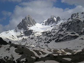
The highest peaks of Prenj in spring |
||
| Highest peak | Zelena glava ( 2115 m ) | |
| location | Bosnia and Herzegovina | |
|
|
||
| Coordinates | 44 ° N , 18 ° E | |
| Type | Fold Mountains | |
The Prenj is a part of the Dinaric Mountains in the south of Bosnia and Herzegovina , more precisely in the northern Herzegovina between the cities of Konjic and Mostar . Its highest peak is the Zelena glava ("Grünkopf", 2115 m ). Ten other peaks are also higher than 2000 meters.
location
The limestone mountains are enclosed in the east, north and west by the Neretva valley and are located about 50 kilometers southwest of Sarajevo . In the south it is separated from the Velež by the Rujište Pass . The area belongs to the municipalities of Konjic, Mostar and Jablanica and stretches for about 25 kilometers in north-south and 20 kilometers in east-west.
Due to the rugged surface and the lack of water in the higher elevations, the Prenj is largely uninhabited. There are also no paved roads leading directly through the mountains. Due to its varied relief, the mountains are popular with hikers and climbers.
history
In the Bosnian War between 1992 and 1995, the front line ran through the middle of the mountains, which have been partially mined since then . This applies in particular to the eastern part near Bijela and the southern areas near Rujište. Due to the difficult terrain, numerous explosive devices were not cleared and continue to pose a threat. Former battle positions can be found at altitudes of over 2000 meters.
summit
Eleven peaks are higher than 2000 meters:
|
|

