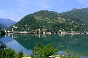
Jablaničko jezero
| Jablaničko jezero | |||||
|---|---|---|---|---|---|
| Jablaničko jezero near Ostrožac | |||||
|
|||||
|
|
|||||
| Coordinates | 43 ° 41 '30 " N , 17 ° 52' 45" E | ||||
| Data on the structure | |||||
| Lock type: | Dam wall | ||||
| Construction time: | 1953 | ||||
| Height of the barrier structure : | 80 m | ||||
| Power plant output: | 165 MW | ||||
| Data on the reservoir | |||||
| Altitude (at congestion destination ) | 270 m. i. J. | ||||
| Water surface | 13.3 km² | ||||
| Reservoir length | 20 km | ||||
The Jablaničko jezero is a reservoir of the Neretva in the north of the Herzegovina-Neretva canton in Bosnia and Herzegovina . When the water level is completely blocked, the water surface of the lake is 270 m above sea level. The lake then has an area of 13.3 km², is about 30 km long and up to 70 m deep. It lies between the towns of Jablanica and Konjic , on whose municipal area it is also located.
The lake was created in 1953 with the construction of the Jablanica hydropower plant, which went into operation in 1955 and today has an output of 165 MW. An 80 m high dam around 5 km north of Jablanica dams the Neretva to Jablaničko jezero. The Rama is the second large river that feeds the lake.
In January 2017 the lake was almost completely drained. It is estimated that up to two million fish were lost.
Individual evidence
- ↑ Focus.ba: “Zbog uništavanja Jablaničkog jezera rukovodstvo EPBiH mora dati ostavke” , accessed on February 5, 2017.

