
Ramsko jezero
| Ramsko jezero | |||||
|---|---|---|---|---|---|
 |
|||||
|
|||||
|
|||||
| Coordinates | 43 ° 48 '15 " N , 17 ° 31' 27" E | ||||
| Data on the structure | |||||
| Lock type: | Dam wall | ||||
| Construction time: | 1968 | ||||
| Height of the structure crown: | 595 m. i. J. | ||||
| Data on the reservoir | |||||
| Water surface | 14.8 km² | ||||
| Reservoir length | 7.5 km | ||||
| Reservoir width | 4.6 km | ||||

The Ramsko jezero is a reservoir of the Rama River in the north of the Herzegovina-Neretva canton in Bosnia and Herzegovina . It is located in the parish of Prozor-Rama , north of the Vran Mountains . When fully blocked, the lake has an area of around 14.8 km², is around 12 kilometers long and a maximum of 95 m deep. The water level is then about 590 meters above sea level. The catchment area of the lake on the upper Rama covers about 550 km².
The Rama reservoir was created in 1968 with the construction of the 100 meter high and 230 meter long Rama dam. In connection with the creation of the reservoir, a total of 2,939 people were resettled from the villages in the upper Rama valley. The remains of some places - especially old tombstones and the foot of the minaret of the former Kopčići mosque - can be visited when the water level is low.
The Franciscan monastery Rama-Šćit is located on the Šćit peninsula in the middle of the lake.
gallery

Satellite image of the lake
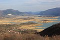
View over the lake when the water level is low
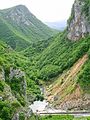
Rama gorge below the dam
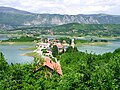
Šćit peninsula with the monastery


Individual evidence
- ↑ data on the lake on rama-prozor.info; accessed on March 24, 2017.
- ↑ N1: Ramsko jezero otkrilo Tragove naselja iz 15 stoljeća. February 15, 2017. Retrieved March 24, 2017.