
Kranjska Gora
|
Kranjska Gora Kronau |
|||
|
|||
| Basic data | |||
|---|---|---|---|
| Country |
|
||
| Historic region | Upper Carniola / Gorenjska | ||
| Statistical region | Gorenjska (Upper Carniola) | ||
| Coordinates | 46 ° 29 ' N , 13 ° 47' E | ||
| surface | 256.3 km² | ||
| Residents | 5,247 (2002) | ||
| Population density | 20 inhabitants per km² | ||
| Post Code | 4280 | ||
| License Plate | KR | ||
| Structure and administration | |||
| Mayor : | Janez Hrovat | ||
| Website | |||


Kranjska Gora ( German : Kronau , translated: Krainer Berg ) is a municipality in the Upper Carniola in the far north-west of Slovenia . The community has around 5000 inhabitants (2004); 1403 inhabitants live in the central town (2002). Kranjska Gora is best known as a resort and winter sports destination .
geography


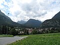
Kranjska Gora is located on the uppermost Wurzener Save ( Slovenian : Sava Dolinka ), the main source river of the Save , between the western foothills of the Karawanken in the north and the central Julian Alps in the south. It is around two and a half kilometers to the Austrian-Slovenian border area with the Wurzenpass , and five kilometers to the Italian border at Rateče (Ratschacher or Weißenfelser Sattel). The Werschetz Pass and the municipality of Bovec are located south of Kranjska Gora .
The municipal area includes the entire upstream Savetal to the mountain Dreiländereck . Rateče (Ratschach) and Planica (Ratschach-Matten), known from ski flying, are part of it. In the south of the municipality, the mountains rise to well over 2000 meters; the most famous peaks there are Prisojnik (2574 m) and Škrlatica (2740 m).
Kranjska Gora had a station on the since the 1870s railway line from Ljubljana to Tarvis . The train has stopped running since March 31, 1966; the line was dismantled from Rateče (Ratschach) to Jesenice (Aßling). In its place there was an asphalt bike path. Until the end of the Habsburg Empire, the place belonged to the Kronland Carniola , with Kranjska Gora forming an independent municipality in what was then the judicial district of Kronau (political district Radmannsdorf ) and was the seat of the district court.

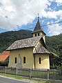
Kranjska Gora, street with a church tower

Cycle path bridge over the Sava near Martuljek
Gozd Martuljek (rod), chapel
Mojstrana, the village


Parish parts
- Belca (German: "Fellinz")
- Dovje (German: "Langenfeld in der Oberkrain")
- Gozd Martuljek (German: "Forest in the Upper Carniola")
- Kranjska Gora (German: "Kronau")
- Log (German: "Loog bei Kronau")
- Mojstrana (German: "Masters in the Upper Carniola")
- Podkoren (German: "Wurzen")
- Rateče (German: "Ratschach") - with Planica
- Srednji vrh (German: "Mitterberg")
- Zgornja Radovna (German: "Ober Rothwein")
Culture and sport
Kranjska Gora is twinned with the Belgian municipality of Waasmunster .
Kranjska Gora hosted the Alpine Junior European Ski Championships in 1977 , the Ski Flying World Championships in 1972 , 2004 and 2010 took place in Planica , and almost every year since 1980 (except for 1999–2012) the ski jumping World Cups , mostly the finals, and since 2014 too for the women.
Since 1961, the municipality has organized the Vitranc Cup for ski racers with giant slaloms and slaloms . Between 1961 and 2006, the HK Kranjska Gora ice hockey club played in the top division of Yugoslavia and Slovenia, respectively.
Personalities
- Jelka Mrak Dolinar (1925-2018), author
- Dejan Košir (* 1973), snowboarder
literature
- Marjan Krušič: Slovenia. Travel Guide. Založba Mladinska Knjiga (publisher), Ljubljana 1999, ISBN 86-11-14549-6 , pp. 245-250.
Web links
Bled | Bohinj | Cerklje na Gorenjskem | Gorenja vas-Poljane | Gorje | Jesenice | Jezersko | Kranj | Kranjska Gora | Naklo | Preddvor · Radovljica | Šenčur | Škofja Loka | Tržič | Železniki | Žiri | Žirovnica .