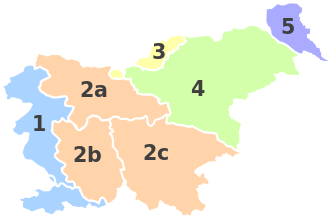
Statistical regions in Slovenia
The statistical regions in Slovenia , Slovenian Statistične regije (singular Statistična regija ) were introduced in May 2005. So far, they have only been used for statistical purposes. In total there are 12 NUTS 3 statistical regions in Slovenia . They probably represent the future administrative structure of the first level, which is to replace the five / seven historical regions .
List of regions
| No. | old no. | Slovenian name |
German translation |
|---|---|---|---|
| 1 | Pomurska | Mur area | |
| 2 | Podravska | Overland area | |
| 3 | Koroška | Lower Carinthia | |
| 4th | Savinjska | Sann area | |
| 5 | Zasavska | Upper Sava region | |
| 6th |
Posavska until 2014: Spodnjeposavska |
[Lower] Sava area | |
| 7th | Jugovzhodna Slovenija | Southeast Slovenia | |
| 8th | Osrednjeslovenska | Central Slovenia | |
| 9 | Gorenjska | Upper Carniola | |
| 10 |
Primorsko-notranjska until 2014: Notranjsko-kraška |
Coastal Inner Carniola (ex Inner Carniola Karst Region) |
|
| 11 | Goriška | Gorica area, Gorizia area | |
| 12 | Obalno-kraška | Coastal and karst area |
On January 1, 2015, the name of the Spodnjeposavska statistical region changed to Posavska , the name of the Notranjsko-kraška region to Primorsko-notranjska .
The Posavska region was expanded in 2015 to include the two municipalities Radeče and Bistrica ob Sotli from the Savinjska statistical region , while the Litija municipality from the Osrednjeslovenska region was reclassified to the Zasavska region.
This changed the borders of four NUTS 3 regions and the two NUTS 2 regions.
Reorganization

1 = coastal region • 2 = Carniola • 2a = Upper Carniola • 2b = Inner Carniola • 2c = Lower Carniola and Weißkrain • 3 = Carinthia • 4 = Lower Styria • 5 = Übermurgebiet
After the founding of the state, Slovenia had not introduced an explicit hierarchical administrative structure above the municipal level. The historical regions that go back to the common monarchy with Austria are traditionally anchored. They still represent the crown lands , the Duchy of Carniola , the remaining coastal lands and the parts of Carinthia , Styria and Hungary that have come to Slovenia .
The Slovenian government is currently planning a new administrative structure for Slovenia. The number of these regions has not yet been defined. However, it is assumed that there are 12 to 14 regions. The plans will be submitted to parliament for approval after public announcement. Constitutional amendments have already been adopted by the National Assembly which should allow the creation of new regions. If the plan is adopted by 12 administrative regions, these will most likely correspond to the current statistical regions.
See also
Web links
Individual evidence
- ↑ As of 2015, see for example Slovene Municipalities in Numbers , stat.si, accessed November 1, 2015 (for the individual municipalities).
- ↑ Cf. Posavina
- ↑ See also Gorica / Görz , Soča Valley
- ↑ See also Kras / Karst , Primorska , histor. Austrian coastal country
- ↑ REGULATION (EU) No. 1319/2013 OF THE COMMISSION of December 9, 2013 ... Creation of a common classification of territorial units for statistics (NUTS) (PDF; 1855 kB), accessed on July 28, 2014.
- ↑ NUTS Regulation amended , www.stat.si (English), amendment to the NUTS Regulation , accessed on November 3, 2015.
- ↑ Notranjsko-kraška per postala primorsko-notranjska. primorske.si, December 28, 2013, accessed November 1, 2015.


