
Savinjska
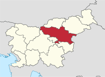
Savinjska (Slovenian: Savinjska statistična regija ) is a statistical region in Slovenia at NUTS 3 level.
The region intended for statistical purposes was introduced in May 2005. It currently includes 33 municipalities. The largest city in the 2,384 km² region is Celje. The population on January 1, 2014 was 259,853.
The Savinjska region was reduced in size from 2015 by the two municipalities of Radeče and Bistrica ob Sotli , these will be reclassified into the then renamed Posavska statistical region .
| coat of arms | local community | German name | map | Area km² |
Residents (January 1, 2014) |
Ew./ km² |
NUTS3 code |
|---|---|---|---|---|---|---|---|
|
|
Braslovče | Fraßlau |
|
55.0 | 5,442 | 99 | SI014 |
|
|
Celje | Cilli |
|
94.9 | 48,868 | 515 | SI014 |
|
|
Dobje | Dobje at Montpreis |
|
17.5 | 968 | 55 | SI014 |
|
|
Dobrna | Neuhaus |
|
31.7 | 2,215 | 70 | SI014 |
|
|
Gornji degree | Oberburg |
|
90.1 | 2,628 | 29 | SI014 |
|
|
Bunk | Drachenburg |
|
89.7 | 3.114 | 35 | SI014 |
|
|
Laško | Tüffer |
|
197.5 | 13,327 | 67 | SI014 |
|
|
Ljubno | To run |
|
78.9 | 2,621 | 33 | SI014 |
|
|
Luče | Leutsch |
|
109.5 | 1,492 | 14th | SI014 |
|
|
Mozirje | Prassberg |
|
53.5 | 4,103 | 77 | SI014 |
|
|
Nazarje | Nazareth |
|
43.4 | 2,573 | 59 | SI014 |
|
|
Podčetrtek | Windisch Landsberg |
|
60.6 | 3,318 | 55 | SI014 |
|
|
Polzela | Healing stone |
|
34.0 | 6,060 | 178 | SI014 |
|
|
Prebold | Pragwald |
|
40.6 | 5,002 | 123 | SI014 |
|
|
Rečica ob Savinji | Riez |
|
30.1 | 2,338 | 78 | SI014 |
|
|
Rogaška Slatina | Rohitsch-Sauerbrunn |
|
71.5 | 10,981 | 154 | SI014 |
|
|
Rogatec | Rohitsch |
|
39.6 | 3.115 | 79 | SI014 |
|
|
Slovenske Konjice | Gonobitz |
|
97.8 | 14,453 | 148 | SI014 |
|
|
Solčava | Sulzbach |
|
102.8 | 523 | 5 | SI014 |
|
|
Šentjur pri Celju | Sankt Georgen near Cilli |
|
222.3 | 18,922 | 85 | SI014 |
|
|
Šmarje pri Jelšah | St. Marein near Erlachstein |
|
107.7 | 10.214 | 95 | SI014 |
|
|
Šmartno ob Paki | St. Martin ad Pack |
|
18.2 | 3.223 | 177 | SI014 |
|
|
Šoštanj | Schönstein |
|
95.6 | 8,806 | 92 | SI014 |
|
|
Štore | Store |
|
28.1 | 4,250 | 151 | SI014 |
|
|
Tabor | Tabor |
|
34.8 | 1,620 | 47 | SI014 |
|
|
Velenje | Wöllan |
|
83.5 | 32,973 | 395 | SI014 |
|
|
Vitanje | Weitenstein |
|
59.4 | 2,235 | 38 | SI014 |
|
|
Vojnik | Hochenegg |
|
75.3 | 8,537 | 113 | SI014 |
|
|
Vransko | Franz |
|
53.3 | 2,597 | 49 | SI014 |
|
|
Zreče | Rötschach |
|
67.0 | 6,358 | 95 | SI014 |
|
|
Žalec | Sachsenfeld |
|
117.1 | 21,255 | 182 | SI014 |
| total |
Individual evidence
- ^ Territorial units and house numbers by the municipalities, Slovenia, quarterly , www.stat.si, English, accessed on August 1, 2014
- ↑ SI STAT
- ↑ Article on name and area changes in NUTS 3 from 2015 ( memo of November 17, 2014 in the Internet Archive ), www.stat.si, English, accessed on July 28, 2014.

Braslovče · Celje · Dobje · Dobrna · Gornji Grad · Kozje · Laško · Ljubno · Luče · Mozirje · Nazarje · Podčetrtek · Polzela · Prebold · Rečica ob Savinji · Rogaska Slatina · Rogatec · šentjur · Konjice · Šmarje pri Jelšah · Šmartno whether Paki · Solčava · Šoštanj · Štore · Tabor · Velenje · Vitanje · Vojnik · Vransko · Žalec · Zreče