Ljubno
| Ljubno | |||
|
|||
| Basic data | |||
|---|---|---|---|
| Country |
|
||
| Historic region | Lower Styria / Štajerska | ||
| Statistical region | Savinjska (Sann area) | ||
| Coordinates | 46 ° 21 ' N , 14 ° 45' E | ||
| height | 423 m. i. J. | ||
| surface | 78.9 km² | ||
| Residents | 2,685 (2008) | ||
| Population density | 34 inhabitants per km² | ||
| Post Code | 3333 | ||
| License Plate | CE | ||
| Structure and administration | |||
| Mayor : | Franjo Naraločnik | ||
| Website | |||
Ljubno (German Laufen ) is a municipality in the historical region of Štajerska ( Lower Styria ) in Slovenia .
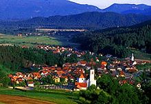
The total community, which consists of nine localities, has 2685 inhabitants. The main town Ljubno ob Savinji alone has 1155 inhabitants and is located in the Savinjsk Alps at the confluence of the Ljubnica and Savinja rivers . It has been the center of the timber industry here for five centuries. Until the end of the Habsburg Empire, the village belonged to the Kronland Carniola , with Ljubno forming an independent municipality in the judicial district of Radmannsdorf (political district Radmannsdorf ). In 2001 a museum was set up that shows the timber trade and rafting during this period.
In 1931 the first ski jumping events took place in Ljubno. In 1953 the 60 m hill was inaugurated and in 1955 the 25 m hill for the youth followed. The name of the ski jumping facility is Logarska dolina . Jumping has been taking place here since 2006 as part of the Ski Jumping Continental Cup and since 2006 also in the Women's Ski Jumping World Cup .
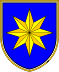
coat of arms
Description : In blue with a golden thread border, a six-pointed faceted golden star .
Districts of the entire municipality
- Juvanje (German Juvaine )
- Ljubno ob Savinji (Eng. Laufen an der Sann )
- Meliše (German Mellische )
- Okonina (German church village )
- Planina (German Montpreis )
- Primož pri Ljubnem (German: Sankt Primusberg bei Laufen )
- Radmirje (German Frattmannsdorf )
- Savina (German Sannboden )
- Ter (German Thörberg )


