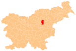
Žalec
| Žalec | |||
|
|||
| Basic data | |||
|---|---|---|---|
| Country |
|
||
| Historic region | Lower Styria / Štajerska | ||
| Statistical region | Savinjska (Sann area) | ||
| Coordinates | 46 ° 15 ' N , 15 ° 10' E | ||
| surface | 117.1 km² | ||
| Residents | 21,525 (2008) | ||
| Population density | 184 inhabitants per km² | ||
| Post Code | 3310 | ||
| License Plate | CE | ||
| Structure and administration | |||
| Mayor : | Janko Kos | ||
| Website | |||
Žalec ( German : Sachsenfeld ) is a municipality in the Spodnja Štajerska region (Lower Styria) in Slovenia .
Live in the town of Žalec, including the incorporated neighboring towns; around 21,000 inhabitants. It is also the administrative center of the Savinja Valley .
The town was first mentioned in 1182. As early as 1256, Žalec received market rights . The valley around Žalec is characterized by many hop fields , which can also be seen in the coat of arms. The area is also called the valley of green gold . The grotto Pekel ( Jama Pekel ) is worth seeing . It was already inhabited by Neanderthals . A 4 m high stalactite waterfall is particularly impressive .
Districts of the entire municipality
- Arja vas , (German Arndorf )
- Brnica , (German Bernitz )
- Dobriša vas , (German Ehrendorf )
- Drešinja vas , (German threshing village )
- Galicija , (German Gallizien )
- Gotovlje , (German Guttendorf )
- Griže , (German Gries )
- Hramše , (German Chramschen )
- Kale , (German Kaal )
- Kasaze , (German Kaschitz )
- Levec , (German Lehndorf )
- Liboje , (German Sankt Elisabeth )
- Ložnica pri Žalcu , (German Lotschitz an der Sann )
- Mala Pirešica , (German Kleinpireschitz )
- Migojnice , (German Megoinitz )
- Novo Celje , (German New Cilli )
- Pernovo , (German Bernau )
- Petrovče , ( Eng . Pletrovich )
- Podkraj , (German Podkrei )
- Podlog v Savinjski Dolini , (German Bodlag )
- Podvin , (German Podwein )
- Pongrac , (German Sankt Pankratz )
- Ponikva pri Žalcu , (German Ponigl near Cilli )
- Ruše , (dt. Rosendorf )
- Spodnje Grušovlje , (German Lower Groschaullach )
- Spodnje Roje , (German Lower Roja )
- Studence , (German Studenzen )
- Šempeter v Savinjski dolini , (Eng. Sankt Peter im Sanntal )
- Velika Pirešica , (German Großpireschitz )
- Vrbje , (German Werbiach )
- Zabukovica , (German Buchberg )
- Zalog pri Šempetru , (German noble farm )
- Zaloška Gorica , (German: Gross Goritz )
- Zavrh pri Galiciji , (dt. Hundred ox )
- Zgornje Grušovlje , (German Ober Groschaullach )
- Zgornje Roje , (German Ober Roja )
- Žalec , (German Sachsenfeld )
- Železno , (German Eisenfeld )
Web links
Commons : Žalec - collection of images, videos and audio files
- Website of the municipality Slovene
- Pekel grotto in Slovenian and English
- Information in German ( Memento from August 18, 2012 in the Internet Archive )
- Tourist information
- History of the city

