
Waasmunster
| Waasmunster | |||
|---|---|---|---|

|

|
||
|
|||
| State : |
|
||
| Region : | Flanders | ||
| Province : | East Flanders | ||
| District : | Dendermonde | ||
| Coordinates : | 51 ° 7 ' N , 4 ° 5' E | ||
| Area : | 31.93 km² | ||
| Residents: | 10,801 (Jan. 1, 2019) | ||
| Population density: | 338 inhabitants per km² | ||
| Post Code: | 9250 | ||
| Prefix: | 052, 09, 03 | ||
| Mayor: | Michel Du Tré ( CD&V ) | ||
Local government address : |
Gemeente Waasmunster Vierschaar 1 9250 Waasmunster |
||
| Website: | www.waasmunster.be | ||

Waasmunster is a Flemish municipality on the Durme in the province of East Flanders with 10,801 inhabitants (as of January 1, 2019).
Dendermonde is 8 kilometers south, Antwerp 25 km northeast, Ghent 26 km southwest and Brussels about 35 km southeast.
Waasmunster has 3 parishes. De Ruiter, Sombeke and the center. The toponym Waasmunster is said to come from Waes-Monasterium, which means "monastery in Waasland". The Roosenberg Abbey, which belongs to the Order of the Victorians, was built by the Doorniker bishop Walter van Marvis in the course of the 13th century. The castle Les Gobelets was built in the early 20th century neoclassical styles.
Waasmünster's coat of arms depicts a mermaid holding up a turnip. They were grown as early as the 16th century, especially as they were used as green fodder in the rest of Flanders. The flag is blue and yellow.
The community has a motorway exit on the A14 / E 17 . In Sint-Niklaas - Sinaai , Lokeren , Zele and Dendermonde are the next regional stations .
Waasmunster is twinned with the Slovenian municipality of Kranjska Gora .
politics
mayor
Mayors were:
- Baron Victor de Neve de Roden (1833–1851; 1862–1878),
- Jean Van den Bogaerde ,
- Baron Emile de Neve de Roden ( Catholic ) (1885–1915),
- Maria Moens ( CVP ) (1950–1976),
- René Bocklandt (CVP) (1977–1982),
- Willy Strobbe (CVP) (1982-1994),
- Eric Van Mele ( SP ) (1995-2000),
- Rik Daelman ( VLD ) (2001-)
Web links
photos

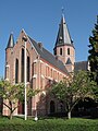
Waasmunster, Church of Our Lady

Waasmunster, one street
Ruiter, church


Aalst | Aalter | Assenede | Berlare | Beveren | Brakel | Buggenhout | De Pinte | Deinze | Denderleeuw | Dendermonde | Destelbergen | Eeklo | Erpe-Mere | Evergem | Gavere | Ghent | Geraardsbergen | Haaltert | Hamme | Herzele | Horebeke | Caprijke | Kluisbergen | Kruibeke | Kruisem | Laarne | Lebbeke | Lede | Lierde | Lievegem | Lochristi | Lokeren | Maarkedal | Maldegem | Melle | Merelbeke | Moerbeke | Nazareth | Ninove | Ooster cele | Oudenaarde | Ronse | Sint-Gillis-Waas | Sint-Laureins | Sint-Lievens-Houtem | Sint-Martens-Latem | Sint-Niklaas | Stekene | Temse | Waasmunster | Wachtebeke | Wetteren | Wichelen | Wortegem-Petegem | Zele | Zelzate | Zottegem | Zulte | Zwalm