
De Pinte
| De Pinte | |||
|---|---|---|---|

|

|
||
|
|||
| State : |
|
||
| Region : | Flanders | ||
| Province : | East Flanders | ||
| District : | Ghent | ||
| Coordinates : | 51 ° 0 ′ N , 3 ° 39 ′ E | ||
| Area : | 17.98 km² | ||
| Residents: | 10,683 (Jan 1, 2019) | ||
| Population density: | 594 inhabitants per km² | ||
| Post Code: | 9840 | ||
| Prefix: | 09 | ||
| Mayor: | Hilde Claeys (RUIMTE) | ||
Local government address : |
Koning Albertlaan 1 9840 De Pinte |
||
| Website: | www.depinte.be | ||

De Pinte is a municipality in the province of East Flanders with 10,683 inhabitants (as of January 1, 2019). It lies between the Scheldt and the Leie, between 7.5 and 10 m above sea level, with the Scheldal marking the lowest point. Patron saint of the Parish De Pinte is St. Nicholas of Tolentino .
history
The name of the parish is borrowed from a hostel (Het Pijntken, today Pintestraat 69) and was first used as a name for the parish when it was separated as a hamlet from the parish of Nazareth on June 2, 1868, at that time it also became "Klein Nazareth " called. At the end of the 19th century, a few horticultural companies settled there, which were later connected to each other in the 20th century. From 1839 De Pinte was also a stop on the Gent-Kortrijk train connection, and from 1857 also on the Gent-Oudenaarde line.
The colors of De Pintes are red and white. The flag can be described as follows:
- Divided by red and silver in a ratio of 2: 3, in the red heart shield three eight-pointed golden stars (2: 1) van goud, and twelve silver rectangles (4: 1: 7).
Community structure
The municipality consists of the core town and the district Zevergem, which was incorporated into De Pinte in 1977 . The bizarre southern border was corrected and has since run along the Scheldt. In terms of population, De Pinte is larger than Zevergem, but in terms of area, both are more or less equivalent. In general, the Oudenaardse Steenweg (N60) is perceived as the border between the two. In the north the community borders on Sint-Martens-Latem , in the east on Ghent, in the south on Merelbeke and Gavere and in the west on Nazareth . De Pinte borders in detail on the following sub-municipalities of these municipalities:

|


Zevergem
The village of Zevergem is located on the Scheldt and is one of the oldest so-called riverside villages on the Scheldeveld , it was first mentioned in 964 as Sewaringhem . The name is derived from Saiwiwaringa heim (home of those of Saiwirwar). The rule of the village was under the von Severghem family until Rodolf de Rode gave it to the Ghent St. Pietersabdij (Abbey) in 1232 in exchange for goods in Munte and Balegem . It is particularly nice for cyclists or walkers between Zevergem and today's canalized Scheldt. Older arms of the Scheldt, such as the Doornhammeke, are now valuable natural areas with breeding grounds for all kinds of bird species. Disappeared the stone establishments which meet the Scheldt stone produced only remaining water plants are evidence of this past. The football club VC Zevergem Sportief is affiliated with the KBVB.

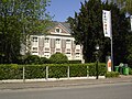
Former parish hall
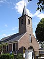
Church of Our Lady
Former pastorei

The Doornhammeke

Old Scheldt to Zevergem

Welden Castle
_-_Former_townhall.jpg)

_-_Rectorie.jpg)

_-_oude_Scheldearm_(Doornhammeke).jpg)

Population development

- Source: NIS - Note: 1876 to 1970 = population censuses as of December 31; 1868 = number of inhabitants on December 31; from 1977 = population on January 1st
- 1977: incorporation of Zevergem and areas of Melsen, Schelderode and Vurste; Assignment of part of Zevergem to Merelbeke (+9.13 km² with 1656 inhabitants)
politics

De Pintes mayor is Martin Van Peteghem . He presides over a council of mayors and aldermen made up of politicians from CD&V and VLD .
traffic
Ghent is 7 kilometers (km) northeast, Deinze 8 km southwest, Oudenaarde 16 km south, Kortrijk 32 southwest, Bruges 37 km northwest and Brussels 52 km southeast. De Pinte is cut through by the Oudenaardsesteenweg (N60). The A 14 ( E17 ) connects to it via exit 8. The municipality has a regional train station on the Gent-De Pinte-Deinze-Kortrijk and Gent-De Pinte-Oudenaarde railway lines, which also provide direct connections to Brussels, De Panne and Ronse.
Events
- Every year the cycling event Sneukeltoer De Pinte takes place, in which around 2300 cyclists take part. The proceeds go to a campaign called "Kom op tegen kanker", an alliance against cancer.
- One of the largest music festivals in East Flanders, Zeverrock, is organized in Zevergem every year .
Personalities
- Katrien Devos , Flemish actress
- Tine Ruysschaert , Flemish actress
- Gabriel Ríos (* 1978), well-known singer
- Evy Gruyaert , radio and television presenter
- Frederik Sioen (* 1979), singer-songwriter
- Paul Van Cauwenberge , Rector of Ghent University
partnership
The community has been in partnership with the German community Freiamt (Black Forest) in Baden-Württemberg since 1971 .
Web links
- Official website of the municipality (Dutch)
- Website about, for and by the residents of Zevergem. (Dutch)
Individual evidence
Aalst | Aalter | Assenede | Berlare | Beveren | Brakel | Buggenhout | De Pinte | Deinze | Denderleeuw | Dendermonde | Destelbergen | Eeklo | Erpe-Mere | Evergem | Gavere | Ghent | Geraardsbergen | Haaltert | Hamme | Herzele | Horebeke | Caprijke | Kluisbergen | Kruibeke | Kruisem | Laarne | Lebbeke | Lede | Lierde | Lievegem | Lochristi | Lokeren | Maarkedal | Maldegem | Melle | Merelbeke | Moerbeke | Nazareth | Ninove | Ooster cele | Oudenaarde | Ronse | Sint-Gillis-Waas | Sint-Laureins | Sint-Lievens-Houtem | Sint-Martens-Latem | Sint-Niklaas | Stekene | Temse | Waasmunster | Wachtebeke | Wetteren | Wichelen | Wortegem-Petegem | Zele | Zelzate | Zottegem | Zulte | Zwalm