
Lede
| Lede | |||
|---|---|---|---|

|

|
||
|
|||
| State : |
|
||
| Region : | Flanders | ||
| Province : | East Flanders | ||
| District : | Aalst | ||
| Coordinates : | 50 ° 58 ′ N , 3 ° 59 ′ E | ||
| Area : | 29.69 km² | ||
| Inhabitants: (status) | 17,473 pop (January 1, 2008) | ||
| Population density: | 589 inhabitants per km² | ||
| Post Code: | 9340 | ||
| Prefix: | 053, 09 | ||
| Mayor: | Roland Uyttendaele ( CD&V ) | ||
Local government address : |
Gemeentebestuur Lede Markt 1 9340 Lede |
||
| Website: | www.lede.be | ||
| Community plan |

|
||

Lede is a Belgian municipality in the Denderstreek in the Flanders region . It is located in the province of East Flanders and belongs to the Arrondissement of Aalst .
location
Aalst is 4 km southeast, Dendermonde 11 km northeast, Ghent 20 km northwest, Brussels 30 km southeast and Antwerp 40 km northeast.
history
The current municipality of Lede was created in 1977 through the merger of the main town with the previously independent municipalities and current districts of Impe , Oordegem , Smetlede , Wanzele and Papegem . The Molenbeek runs through Lede and through all districts.
traffic
The next motorway exits are in the south at Aalst and Erpe-Mere on the A10 / E 40 and in the north at Beervelde and Lokeren on the A14 / E 17 .
Lede has its own regional train station on the Ghent - Wetteren - Lede - Aalst - Brussels line.
photos
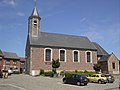
Impe, church: de Sint-Denijskerk

Oordegem, mill: de Fauconiersmolen


.jpg)
Web links
Aalst | Aalter | Assenede | Berlare | Beveren | Brakel | Buggenhout | De Pinte | Deinze | Denderleeuw | Dendermonde | Destelbergen | Eeklo | Erpe-Mere | Evergem | Gavere | Ghent | Geraardsbergen | Haaltert | Hamme | Herzele | Horebeke | Caprijke | Kluisbergen | Kruibeke | Kruisem | Laarne | Lebbeke | Lede | Lierde | Lievegem | Lochristi | Lokeren | Maarkedal | Maldegem | Melle | Merelbeke | Moerbeke | Nazareth | Ninove | Ooster cele | Oudenaarde | Ronse | Sint-Gillis-Waas | Sint-Laureins | Sint-Lievens-Houtem | Sint-Martens-Latem | Sint-Niklaas | Stekene | Temse | Waasmunster | Wachtebeke | Wetteren | Wichelen | Wortegem-Petegem | Zele | Zelzate | Zottegem | Zulte | Zwalm