
Geraardsbergen
| Geraardsbergen | |||
|---|---|---|---|

|

|
||
|
|||
| State : |
|
||
| Region : | Flanders | ||
| Province : | East Flanders | ||
| District : | Aalst | ||
| Coordinates : | 50 ° 46 ′ N , 3 ° 53 ′ E | ||
| Area : | 79.71 km² | ||
| Residents: | 33,439 (Jan 1, 2019) | ||
| Population density: | 420 inhabitants per km² | ||
| Post Code: | 9500, 9506 | ||
| Prefix: | 054 | ||
| Mayor: | Guido De Padt ( Open Vld ) | ||
Local government address : |
Stadsbestuur Geraardsbergen Administratief Centrum Weverijstraat 20 9500 Geraardsbergen |
||
| Website: | www.geraardsbergen.be | ||


Geraardsbergen ( French Grammont , German Gerhardsbergen , local Giesbaargen ) is a town in the Denderstreek of the Belgian province of East Flanders . It consists of 16 sub-communities: the city center and 15 rural communities. The city has 33,439 inhabitants (as of January 1, 2019). One of the sights is the Manneken Pis , the original of which is probably older than the one in the Belgian capital, Brussels . The city, which leans directly on the Oudenberg, is known among cycling fans for the so-called Wall of Geraardsbergen there , a famous climb on the former route of the Tour of Flanders . With the Bosberg , the last ascent of this classic bike is located near Geraardsbergen. Geraardsbergen is also known for its mattentaart . The city's patron saints are St. Bartholomew and St. Hadrian.
history

Geraardsbergen was after 1060 by Baldwin VI. Founded by Flanders because of its strategic location on a hill on the right bank of the Dender on the border with the Duchy of Brabant. The county was bounded by the Scheldt until 1046, when Baldwin V took the area between the Scheldt and Dender. The cities in the newly acquired area or the new foundations had to offer this corresponding protection. Therefore Baldwin bought the hill with the surrounding area from Geraard van Hunnegem , from which the name Geraardsbergen is derived. The Latin name of the place Geroaldi Montem already existed before the oppidum was founded. The suburban Franconian branch Hunnegem is on the left bank and outside the walled city center on the right bank at the foot of the Oudenberg. In 1068 the place acquired city rights from the new Count Balduin VI. The city rights were confirmed in writing by Philip of Alsace at the end of the 12th century.

Manneke Pis is the most famous statue in Geraardsbergen

De Muur van Geraardsbergen (The Wall of Geraardsbergen)
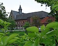
The Hunnegem Priory (2005)
.JPG)


In 1081 Robert I, with the support of Lord von Boelare, convinced the Benedictines to move their abbey from Dikkelvenne to Geraardsbergen. In 1175 the relics of St. Adrian brought from Nicomedia to St. Peter's Abbey, which was then renamed St. Adrian's Abbey. The abbey should be of great importance for urban development. She knew a long and large bloom, which was reflected in a correspondingly important abbey complex. The veneration of St. Adrian as the patron saint protected against the plague, so that Geraardsbergen was better known, so that the city was sometimes even called Adrianopolis . Various miracles have been attributed locally to the veneration of St. Adrian.
From the 12th century Geraardsbergen became a center of the cloth trade. The city developed on the left bank of the Dender from the 13th century. In 1332 new fortress walls, towers and city gates were built. As a result, an upper and lower town developed in Geraardsbergen.
In the 15th and 16th centuries Geraardsbergen was known for the production of tapestries, as was Oudenaarde, Brussels, Aalst and Edingen. The quality of the production was of a very high standard, the showpieces are found in museums around the world (including Vienna, Boston and Madrid).
The development of the city stagnated several times due to sieges, fires and epidemics. In the dispute between the Counts of Flanders and the city of Ghent, Geraardsbergen sided with Ghent and was therefore burned down in 1381 by the Count's troops. Compared to the development of other cities, Aalst and Oudenaarde passed Geraardsbergen. In the 16th century, the city was hit by a great fire in 1549 and various plague epidemics between 1558 and 1585. At the end of the 16th century only 182 houses were still inhabited.
From the 17th century Geraardsbergen began to flourish again, the cloth trade reached its peak in 1697 and the production of lace began. Heavy “Chantilly” from Geraardsbergen in particular was traded worldwide, which reached its greatest boom between 1849 and 1870.
In the meantime, a match factory was built in 1838 and cigars began to be produced in 1849. Geraardsbergen developed into an increasingly important industrial city, which was now also opened up by railroad lines from 1855 to 1867 (Aalst-Brussel; Melle; 's Gravenbrakel).
Geraardsbergen developed into a regional town in the 20th century. Because the city area was too small, the residents increasingly moved to neighboring communities, which subsequently developed towards Geraardsbergen itself and were also merged into the city with the community merger in 1971. However, the more distant outlying communities remained rural and were only added to the city in 1977.
City structure
In addition to the actual city, Geraardsbergen also consists of various sub-communities, which were founded in 1971 (Onkerzele, Overboelare, Goeferdinge and Nederboelare) and 1977 (Schendelbeke, Idegem, Moerbeke, Viane, Zarlardinge, Ophasselt, Smeerebbe-Vloerzegem, Grimminge, Zandbergen, Nieubewenhove) were incorporated.
| # | Surname | Area (km²) |
Population (31/12/2005) |
|---|---|---|---|
| I. | Geraardsbergen | 1.91 | 6,445 |
| II | Overboelare | 7.60 | 3,916 |
| III | Zarlardinge | 6.53 | 962 |
| IV | Goeferdinge | 3.83 | 2,609 |
| V | Nederboelare | 2.16 | 923 |
| VI | Schendelbeke | 5.89 | 1,754 |
| VII | Ophasselt | 7.49 | 1,662 |
| VIII | Smeerebbe-Vloerzegem | 3.66 | 760 |
| IX | Idegem | 3.41 | 1,631 |
| X | Zandbergen | 6.90 | 1,614 |
| XI | Nieuwenhove | 1.99 | 467 |
| XII | Waarbeke | 2.58 | 236 |
| XIII | Grimmings | 4.41 | 934 |
| XIV | Onker cele | 8.31 | 2,738 |
| XV | Moerbeke | 6.43 | 2,968 |
| XVI | Viane | 6.59 | 1,740 |
- Source: City of Geraardsbergen
Overboelare

Overboelare is located in the southwest of Geraardsbergen. The village center has grown together with the city. It originated in the 13th century as the second parish on the Boelare domain, first reported in 822 as 'Buonlare', which is supposed to mean swampy, whale-covered terrain (Germanic 'hlaêri') on flat ground (Germanic 'bôn'). To make the difference to the already existing Parochie Boelare clear, both names of the location on the Dender were added to the name according to Nieder- and Ober- respectively.
Until the French Revolution it belonged to the core area of the Barony of Boelare, in the castellany of the Land of Aalst and therefore shared its history. With the nearby neighbor Goeferdinge it formed a flock of four.
The three-aisled originally classicist St. Algondis Church from 1770 is worth seeing, to which the neo-Gothic transept, as well as the choir, tower and essential parts of the furniture were added in 1864. The KVR Overboelare football club also plays in Overboelare.
Tsarlandings

The village center is less than a kilometer west of the Goeferdinges. The St. Antoniusverering on January 17th and the so-called Trippenworp are special events.
Goeferdinge
_-_Historisch_gebouw.jpg)
Goeferdinge is connected to Overboelare and the center by road construction. It was only very late, in the 15th century, that Goeferdingen was reported as 'Goefferdinghen' (going back to Godafrithinga Haim or Hufe / settlement of Godfried's descendants). Until the French Revolution the parish belonged to the Barony of Boelare, in the castellany and the land of Aalst, together with Overboerlare it formed a group of four. The numerous finds from late early history ( Neolithicum ) and the Roman period illustrate a long history of settlement in the hilly clay landscape of Goeferdinge. The Hogeweg, located on the border with Overboelare, is part of a Roman road that connected Geraardsbergen with the Roman settlement Flobecq - Le Puvinage (Hainaut). The remains of a Gallo-Roman villa were found on the high, fertile fields along this Hogeweg. Together with other sites, e.g. the remains of a Merovingian burial ground (6th and 7th centuries) in Overboelare and the early medieval settlement core of Hunnegem, this indicates a continuity of settlement in the southwestern area of Geraardsbergen since the Gallo-Roman times. The St. Bavo Church was completely rebuilt in the classicist style in 1776, the interior is from the same era. All that remained of the old church was a cuboid baptismal font.
Nederboelare
Nederboelare is located in the north of the Geraardsberg city center, but is also fused with the city. Niederboelare was originally just called Boelare, first reported as 'Buonlare' in 822. (For the history of the name, see Overboelare above.)
Until the French Revolution, it was the center of the Barony of Boelare, in the castellany and the land of Aalst, with which it shares the same history as Overboelare. However, Niederboelare formed a group of four with the nearby Onkerzele.
Worth seeing are the walled castle of Boelare, a complex built in the 18th century in place of the original feudal castle and the former seat of the barony of the same name, as well as the modern St. Makarius Church with its single tower from 1971-72. The architects were Leus and Gavel ( Gent ) and Borremans (Geraardsbergen).
Schendelbeke

In 868 Schendelbeke was first known as 'Scemtlebeke'; mentioned, whereupon it only becomes Scindelbecca in 1186 and then Scendelbeke in 1186. The variant 'Scemtlebeke' that also appears was written down by Romansh-speaking people and is therefore less likely to be considered representative. The first part of the name also remains a mystery. The lordship was at the beginning its own property, a fiefdom of the County of Aalst to a family named after the place. One of the gentlemen Willem Van Schendelbeke, was the Upper Vogt of the Land of Aalst in 1386. At the end of the 13th century, the domain was found in the hands of Jan Geylinck, councilor to the Flemish Count Lodewijk van Crécy . He founded the Carthusian monastery which was later to be transferred to Sint-Martens-Lierde . His heir Jan Hergod gave the rule to Nicolas Van Belle, Baron von Boelare in 1334 and became the centerpiece of the Barony of Boelare until the French Revolution. After that the castle belonged to the parish. The place formed a flock of four with Smeerebbe. The St. Amandus Church from 1669 is well worth seeing. In the meantime it has been rebuilt several times, especially between 1822 and 1890. The interior houses the main altar from 1783 from the disappeared St. Adrian Abbey of Geraardsbergen. The organ from the beginning of the 19th century has been a listed building since 1980, and this has been the case for the entire church since 2003.
Ophasselt
The oldest reports of Ophasselt go back to 963 and 1015, when the place is mentioned as "Haslud". For the following centuries, the rulers of Hasselt were in charge. Ophasselt consisted of three lords in the 15th century, namely Vrijheid, Moenebroek and the village where the church was located. In 1654 it was made a county, owned by Philip Frans du Faing .
The population lived mainly from agriculture in the 19th century, but the place also had industry. The Rapide factory, specializing in farming tools and washing machines, largely dominated daily life. The De Vleeschauwer family, the owners of the factory, put a clear mark on village life and also appointed the last mayor before the municipal merger. The factory name still lives on in the name of the local football club Rapide Club Ophasselt (green-red). The architecturally valuable 'Villa Armand' from the beginning of the 20th century also goes back to the family.
The listed St. Peterskettenkirche (together with the surrounding churchyard) still has elements from the 15th century with its tower and tower pillars, the rest disappeared in a fire around 1600. The current nave dates from 1777, the choir was adapted in 1812. Major restoration work began at the end of 2010. The church and the surrounding cemetery including the wall are protected as a landscape monument. The neoclassical pastorei is also a listed building.
The N8 road runs through Ophasselt.
Smeerebbe-Vloerzegem
The village, populated by 760 inhabitants, actually consisted of two places, which the hyphen name already suggests. Both parts, Smeerebbe and Vloerzegem, belonged independently to the Barony of Boerlare, but they were merged in the 18th century. The St. Amandus Church in Smeerebbe and the St. Matthew Church in Vloerzegem are worth seeing.
The following mayors have existed since Belgian independence until it was incorporated in Geraardsbergen in 1977:
- J. Van Crombrugghe (1830-1842)
- V. De Clippele (1843-1850)
- L. De Backer (1851-1854)
- C. De Ro (1855-1857)
- B. De Wandel (1858–)
- Gustaaf Van Damme
- Richard Vander Stuyft (1936–1964)
- Roger De Nutte (1964-1976)
Idegem
Idegem is the only place on the Dender that still has a ferry crossing. Mentioned in 964 as Idingehem , a form that does not yet deviate much from the original name Idinga Haim, which is Germanic for "hooves / settlement of Ido's descendants". This parish also belonged to the Barony of Boelare, together with Smeerebbe Idegem formed a group of four.
The rule of the village was the beginning of the old Van Idegem or d'Ydeghem family, who were linked by marriage to several powerful Flemish families. In the coat of arms they led two golden crossbars of black. The domain eventually passed into other hands through the marriage of Conrnelias d'Ydeghem de Watou to Antoine-François De Gruutere, who was knighted in 1643. Their descendants called themselves De Gruutere d'Ydeghem.
A classical church was built on the west tower of the 15th century around 1780, with a modified interior. This St. Peter's Chain Church has been a listed building since 1974.
The Wilskracht Idegem football club plays in Idegem.
Zandbergen

.jpg)
The village center is south of the Dender. The train station is to the north of it. The newer Bahnhofsviertel is now connected to Appelterre-Eichem by ribbon development.
Worth seeing are the listed Church of Our Lady with west tower from the 13th century, the water fort de Lalaing, also called Hof von Lier, and the listed Zandbergen train station, which has been in decline since at least 2009 ( Jean-Pierre Cluysenaar ).
The football club SK Zandbergen plays in Zandbergen.
Nieuwenhove
Nieuwenhove has less than 500 inhabitants, it was first reported as Niwehove in 1090 , which can be clearly read as nieuwe hoeve (New Hufe). Niuwenhove shared the history of Waarbeke and was decoupled with Waarbeke from the Barony of Boerlare after 1658. The Gothic Sint-Jan-de-Doperkerk reveals three construction phases. The actual church with its octagonal tower dates from the 13th century, the transept and the village lords' chapel from the 15th century, the portal is from 1772. The building has been a listed building since 1942. In the church there is a carved white stone baptismal font from the 12th to 13th centuries.
Waarbeke

The village is on the provincial border where the Flemish Ardennes merge into the Pajottenland. The place was first mentioned as “Warbegka” in 1117, whereby “waar” can mean a ditch or a lake.
The parish belonged to the core area of the Barony of Boelare until 1658, in the castellany of the Land of Aalst. Together with Nieuwenhove, the place formed a rulership and a group of four. In 1658 this dominion was decoupled and passed to the Van Steenhout or de Steenhault family.
The St. Amandus Church stands on a small hill, around 1847 in a non-strictly classical style. The tall, narrow building has three naves and a built-in west tower, flanked by two niches with images of St. Amandus and St. Roch. The tower houses a carillon, installed in 1970. The furniture dates back to the 19th century.
The village is in the heart of the first officially recognized quiet area in Flanders. The socio-cultural movement around silence and quality of life is based in the old pastorei.
Grimmings

Grimminge is reported in a document as early as 1068. The name means: "Village of Grimo". The first part of the name goes back to the lord or colonel who fortified his manor house in a certain place. So the original name Grimighem was the village of Grimo (ald), Grimmo or Grimmert (Grîminga haim). Other spellings were Grimmine (1121), Grimenghem (1234), Griemeghem (1443) and later later Grieminghen and Grimmingen. From the 13th century the name has been linked to the history of Beaupré Abbey. The coat of arms, a green tobacco plant on a golden ground, refers to the history of the place in connection with tobacco cultivation. Parts of the Raspaillebos lie in the south. The Natuur- en Mileueducatief Centrum (nature and environment teaching center) NMEC De Helix is also located in the village. Well-known bailiffs were: Rogier van Landuyt (1530), Lieven Sierejacobs (1742), Pieter De Cooman (1766), Denijs Exterdael (1769), Adriaan van Damme (1770), Bert. van Damme (1776)
Well-known mayors were: Jan de Gheyter (1730), Denijs Exterdael (1742), J.-B. Doolaeghe (1769), Christian Rigo (1771), P. de Geyter (1801), J. Walraevens (1808), Frans Rens (1812), B. Prové (1820), EFG Germanes (1825), P. Steenhout (1837 ), EFG Germanes (1848), P. Steenhout (1873), H. van Helleputte (1880), T. Germanes (1882), J. De Bruyn (1888), Jan Van Bever, Pieter V Klassenbroeck, René Van Eesbeek Elie De Mole (1958)
Onker cele
Onkerzele was first mentioned in 1149 as Unchresele . While the first part of the name remains unclear, the second can be clearly derived from the Germanic sali (Sel), which means something like small hooves, where people and animals live together in a room, a 'hall'.
The parish church belonged to the barony of Boelare, to the castellany and to the land of Aalst until the French Revolution. Together with Niederboelare it formed a group of four. The St. Martin's Church from 1842 was built in early neo-Gothic style, the interior still has some pieces of the old church. The football club FC Eendracht Onkerzele plays in Onkerzele.
Moerbeke
In the north of Moerbeke lies the hamlet of Atembeke, in the northeast lies the Raspaillebos. Moerbeke is the birthplace of Wilhelm von Moerbeke . The soccer club FC Eendracht Moerbeke also plays in Moerbeke.
Viane
Viane is located in the east of Geraardsbergen near the border with Hainaut. The rural village is separated from the remainder of Geraardsbergen by the river Mark, a tributary of the Dender. Every year the GP Paul Borremans cycling race is organized in Viane. The St. Amandus Church, a neo-Gothic hall church from 1843 and the castle de Blondel de Beauregard, which is protected together with its landscape, are worth seeing.
Attractions
- The Great Market with its neo-Gothic St. Bartholomew's Church and the neo-Gothic town hall is worth seeing, at the foot of which stands the Geraardsbergen Manneken Pis, which looks quite similar to that of Brussels, but is proven to be 160 years older according to city accounts. In the square in front of the town hall there is also the (spring) fountain called Marbol. This is a replica of the original fountain, which was removed from the site in 1930. A fountain is mentioned as early as the 14th century.
- The old hospital with the baroque hospital church 1761–1763.
- The St. Adrians Abbey, founded in 1096, before its closure during the French Revolution, was one of the most powerful Benedictine abbeys in Flanders.
- Hunnegem , Romanesque church and priory. The interior of the church and the Paxsaal are pearls of neo-Gothic painting.
- The Oudenberg (Eng. "Altenberg") with the wall of Geraardsbergen , the king's hill of various cycling championships, including the Tour of Flanders. In 2004 the city was also ridden by the Tour de France. The particular difficulty for cyclists results from the horizontally laid cobblestones, which actually form small steps. The Liebfrauenkapelle is located at the top of the Altenberg; a place of pilgrimage. Another height from the cycling races is the Bosberg , which lies on the border with Galmaarden .
- De Permanensje: audiovisual regional visitor center of the Flemish Ardennes
- Geraardsbergen also has a historic city-giant couple , Goliath and Agnes plus their daughter Kinneke Baba . Kinneke Baba is also the name of an association of Geraardsberg students at the Free University of Brussels. The students from the University of Ghent and the Ghent Universities met in 1073 in the student club “De Geraard”.

St. Bartholomew Church
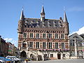
town hall

Manneken Pis

De Marbol

Liebfrauenkapelle on the Oudenberg


.JPG)
Culture
Every year in February the end of winter is celebrated with crackling and barrel brandy. This centuries-old double festival was included in the inventory of the Intangible Heritage of Flanders (2009) and inscribed on the Unesco 2010 representative list of the intangible cultural heritage of humanity.
tourism
The Denderroute South and “Denderende Steden” run through the city.
Culinary

The Mattentaart is a biscuit made from acidified milk. The Geraardsberger Mattentaart was recognized by the European Union as the first Flemish local product as a protected designation of origin in 2007.
nature
The municipality has recently got involved in the pilot project “Stiltegebied Dender-Mark” in order to preserve the quiet character of the region in consultation with the municipalities of Galmaarden and Ninove , the provincial governorates of East Flanders and Flemish Brabant , AMINAL and the Flemish Region. Geraardsbergen includes the following natural areas: Moenebroek , Boelaremeerse , Gemene Meers , Raspaillebos , Kortelake and Rietbeemd .
politics
Mayors were among others:
- Franz Rens (liberal) (1894–1898)
- Robert Rens (liberal) (1953-1958)
- Agnes Allebosch-De Munter ( CVP ) (1977-1994)
- Freddy De Chou ( sp.a ) (1995-2000)
- Guido De Padt ( Open VLD ) (2001-2006)
- Freddy De Chou (sp.a) (2007–)
sons and daughters of the town
- Wilhelm von Moerbeke (around 1215–1286), clergyman and translator.
- Percheval van den Noquerstocque , 15th century, friend of Aegidius, singer at the papal chapel
-
Pieteren den Brant , late medieval poet (1435) of the Geraardsberg manuscript and, among other things, author of "de properheden vande vier complexien"

- Guillebert de Metz , 15th century, scribe and miniaturist, copyist, aldermen of the city, librarian of Philip the Good
- Johannes Hauchin (1527–1589), Archbishop of Mechelen
- Gabriel Grupello (1644–1730), Italian-Flemish sculptor
- Constant Van Crombrugghe (1789–1865), canon and founder of the religious orders of Dochters van Marie , Dames van Maria and Father Jozefieten
- Frans Rens (1805–1874), Flemish scholar, active in the Flemish Movement
- Eugène-François de Block (1812–1893), genre painter, etcher and draftsman
- Ildephonse Stocquart (1819–1889), painter
- Albrecht Lefebvre (1879–1951), painter, impressionist
- Paul Van Steenberge (1884–1962), brewer, university lecturer and politician
- Jan De Cooman (1893–1949), painter
- Karel Rosier (1906–1990), plastic artist and poet
- Frans Van Coetsem (1919–2002), Belgian-American linguist and university professor ( Leuven , Leiden and Cornell )
- Roel D'Haese (1921–1996), sculptor and graphic artist
- Cyriel Delannoit (1926–1998), European boxing champion
- Reinhoud D'Haese (1928–2007), sculptor, draftsman and graphic artist
- Roger Blanpain (* 1932), Dean of Law at the Catholic University of Leuven
- Herman Vanden Berghe (* 1933), human geneticist, honorary vice-rector of the Catholic University of Leuven
- Paul Van den Berghe (* 1933), Bishop of Antwerp
- Herman Vekeman (* 1938), literary scholar, author, professor at the University of Cologne
- Ferdi Van Den Haute (* 1952), racing cyclist
- Guido De Padt (* 1954), politician
- Marie-Christine Deurbroeck (* 1957), former athlete
- Lodewijk Aerts (* 1959), Catholic clergyman, Bishop of Bruges
- Michaël Borremans (* 1963), artist
- Alain Van Den Bossche (* 1965), racing cyclist
- Koen Pletinckx (* 1974), composer and computer specialist
- Lisbeth Imbo (* 1976), radio and television presenter
- Jan Soetens (* 1984), cyclocross and road cyclist
- Soetkin Baptist (* 1985), singer of the groups Ishtar, Olla Vogala en Encantar
- Dean Delannoit (* 1989), singer

Web links
- City homepage (Dutch)
Individual evidence
Aalst | Aalter | Assenede | Berlare | Beveren | Brakel | Buggenhout | De Pinte | Deinze | Denderleeuw | Dendermonde | Destelbergen | Eeklo | Erpe-Mere | Evergem | Gavere | Ghent | Geraardsbergen | Haaltert | Hamme | Herzele | Horebeke | Caprijke | Kluisbergen | Kruibeke | Kruisem | Laarne | Lebbeke | Lede | Lierde | Lievegem | Lochristi | Lokeren | Maarkedal | Maldegem | Melle | Merelbeke | Moerbeke | Nazareth | Ninove | Ooster cele | Oudenaarde | Ronse | Sint-Gillis-Waas | Sint-Laureins | Sint-Lievens-Houtem | Sint-Martens-Latem | Sint-Niklaas | Stekene | Temse | Waasmunster | Wachtebeke | Wetteren | Wichelen | Wortegem-Petegem | Zele | Zelzate | Zottegem | Zulte | Zwalm