
Destelbergen
| Destelbergen | |||
|---|---|---|---|

|

|
||
|
|||
| State : |
|
||
| Region : | Flanders | ||
| Province : | East Flanders | ||
| District : | Ghent | ||
| Coordinates : | 51 ° 3 ' N , 3 ° 48' E | ||
| Area : | 26.56 km² | ||
| Residents: | 18,271 (Jan 1, 2019) | ||
| Population density: | 688 inhabitants per km² | ||
| Post Code: | 9070 | ||
| Prefix: | 09 | ||
| Mayor: | Marc De Pauw ( Open VLD ) | ||
Local government address : |
Gemeentebestuur Dendermondesteenweg 430 9070 Destelbergen |
||
| Website: | www.destelbergen.be | ||

Destelbergen is a Flemish municipality in the province of East Flanders in Belgium with 18,271 inhabitants (as of January 1, 2019). The residential community is located in the greater Ghent area.
Destelbergen reaches Ghent in the east. The border with Melle and Gent is determined by the bed of the Zeeschelde .
Brussels is 42 km southeast and Antwerp 45 km northeast.
The next motorway exits are on the eastern Ghent motorway ring with the Destelbergen and Heusden junctions .
history

Destelbergen was inhabited long before our era. According to archaeological excavations and studies, human settlement in the sub-communities of Destelbergen and Heusden extends to the prehistoric times of the Mesolithic (approx. 10,000 to approx. 5000 BC).
The name Destelbergen also goes back a long way in time. The former community name “Thesle” refers to the sand hills in the center that have now largely disappeared. The second part of the name "-bergen" also indicates this. In 962 Destelbergen was donated to St. Peter's Abbey in Ghent by Wichman IV , Count of Hamaland . Until the French Revolution, power would remain in the hands of the abbey. In addition to a number of large estates, the abbey also owned numerous fiefs in the community. These grew into castles or outdoor domiciles, some of which can still be found today. The proximity to Ghent ensured that Destelbergen had to suffer a lot during the wars of faith and the wars with Louis XIV, including the parish was plundered three times between 1675 and 1677.
In the Middle Ages, peat extraction on the Scheldt was extremely important. The 19th century, on the other hand, was marked by the beginning of industries such as brick and oil production.
In 1794 Destelbergen was 1922 hectares in size and had only 2250 inhabitants. In 1801 2454 souls lived here and on December 31, 1862 there were 5200 inhabitants.
Community structure
The municipality of Destelbergen consists of the eponymous Destelbergen and the sub-municipality Heusden.
The municipality of Destelbergen consisted of the individual areas Panhuis, Achtendries, Klein Gent, Kleinen Hoenderhoek, Sint-Pietershof, het Veldeken, de Visschershoek, de Schijtershoek, de Molenhoek, het Gouden Hand, het Peerdeken, de Hoogstraat, het Haanhout, Toleinde, Blauwhof and Eenbeekeinde, which connects to the urbanized Sint-Amandsberg and Gent. Beervelde became its own parish in 1809, and then in 1921 its own parish.
Around 50 years later, when Belgian communities merged in 1977, Destelbergen and Heusden were merged in the south of Destelbergen-centrum. In recent years the community has developed into a residential community, even if its rural character, probably also due to the presence of the many castle parks, has not been largely preserved.

| # | Surname | surface | population |
|---|---|---|---|
| I. | Destelbergen | 12.50 | |
| II | Heusden | 14.06 |
The municipality of Destelbergen borders on the following sub-municipalities: a. Lochristi , b. Beervelde (Lochristi), c. Laarne , d. Wetteren , e. Melle , f. Gentbrugge (Gent), g. Sint-Amandsberg (Gent), h. Oostakker (Ghent)
Heusden
Heusden was an independent municipality until 1977. The village is located on the Scheldt and about five kilometers east of the city of Ghent, but within the Ghent Ring (R4). The A14 (European E17) separates Heusden from Destelbergen. When the Scheldt was straightened in 1882, Heusden lost part of its land area to Melle .
The place was first mentioned in the 11th century, when Abbot Othejbold noted in a document that the place, where the Lords of Heusden later had the say, should have belonged to the St. Bavo Abbey before the invasion of the Normans. After the wedding of Beatrix van Heusden with Zeger III. Burgrave of Ghent In 1212, the burgraviate of Ghent was extended to Heusden and Heusden was his seat. Heusde belonged to the Burgraves of Ghent until the French Revolution. This title is carried by various noble families. Among other things, Heusden is known for the well-known Cistercian abbey Nieuwenbosch , which was founded in 1247, but which was destroyed by the iconoclasm in 1578 and the monastery was dissolved. The nuns later moved to Ghent. Since Heusden was part of the defensive belt around Ghent during this period, the municipality was also plundered several times. Industrialization also began here in the 19th century. An annual event in Heusden is the Kermiskoers "Grote Prijs Maurice Raes" popularly known as Heusden Koers .
Attractions
- The Holy Cross Church from 1844
- Former lease hooves Bosseveerhoeve or hoeve Ten Bossche of the disappeared Nieuwenbosch or Nonnenbos Abbey (1247–1579) on the Scheldt
- The Sandberg (to the left Zandberg) : a strange dune top
- The Kalverbos nature reserve with old Scheldt meanders , lakes, old peat pits and courtyards, a significant water game area, swamp flora.
- The numerous castles / estates
- The Harry Malter family park, a recreation park donated by Harry Malter , known for the Piste circus

Heusden village center
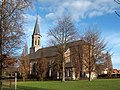
Heiligkreuzkirche, 1844–1845 (neo-Gothic)
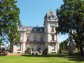
Stas de Richelle Castle (18th century)

House from 1653

Former parish hall

The Bosseveerhoeve of the disappeared Nieuwenbosch Abbey


_-_Belgi%C3%AB.jpg)

Attractions
- The community has various castles. An area with some forts and associated hooves , paths and water systems is protected as a village view.
- The Dammtalgebied (ndl. Damvalleigebied)
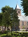
The Liebfrauen-zum-Schnee-Kirche Destelbergen
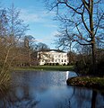
The Van Acker domain, with a castle on top (once Kasteel Van Acker, around 1914) that now serves as a community center.

A Gallic hoof.


Personalities
- Dirk Brossé (* 1960), (Heusden), conductor
- Octave Landuyt (* 1922), (Heusden), Kunstenaar
- Alex Vercauteren , (Heusden), commissioner of the murder of Karel Van Noppen
- Jan Becaus , (Heusden), VRT journalist
- Siegfried Bracke , (Heusden), N-VA politician and former VRT journalist
- Johan Tas , (Heusden), VRT journalist
- Dimitri De Fauw (1981–2009), (Heusden), cyclist / pistier
- Johan Mussche , (Heusden), Manager of the Year 2000, CEO Spector
Population development

- Source: NIS - Note: 1806 to 1970 = censuses as of December 31; 1921 = population on December 31; from 1977 = population on January 1st
- 1921: Assignment of a part of the area for the establishment of the municipality of Beervelde (-6.70 km² with 1300 inhabitants)
- 1977: Incorporation of Heusden (+14.13 km² with 6696 inhabitants)
Web links
Aalst | Aalter | Assenede | Berlare | Beveren | Brakel | Buggenhout | De Pinte | Deinze | Denderleeuw | Dendermonde | Destelbergen | Eeklo | Erpe-Mere | Evergem | Gavere | Ghent | Geraardsbergen | Haaltert | Hamme | Herzele | Horebeke | Caprijke | Kluisbergen | Kruibeke | Kruisem | Laarne | Lebbeke | Lede | Lierde | Lievegem | Lochristi | Lokeren | Maarkedal | Maldegem | Melle | Merelbeke | Moerbeke | Nazareth | Ninove | Ooster cele | Oudenaarde | Ronse | Sint-Gillis-Waas | Sint-Laureins | Sint-Lievens-Houtem | Sint-Martens-Latem | Sint-Niklaas | Stekene | Temse | Waasmunster | Wachtebeke | Wetteren | Wichelen | Wortegem-Petegem | Zele | Zelzate | Zottegem | Zulte | Zwalm