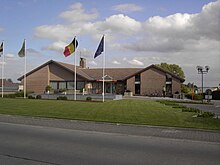
Lierde
| Lierde | ||
|---|---|---|

|

|
|
|
|
||
| State : |
|
|
| Region : | Flanders | |
| Province : | East Flanders | |
| District : | Oudenaarde | |
| Coordinates : | 50 ° 49 ′ N , 3 ° 51 ′ E | |
| Area : | 26.13 km² | |
| Residents: | 6616 (Jan. 1, 2019) | |
| Population density: | 253 inhabitants per km² | |
| Post Code: | 9570 (Deftinge, Sint-Maria-Lierde) 9571 (Hemelveerdegem) 9572 (Sint-Martens-Lierde) |
|
| Prefix: | 055 | |
| Mayor: | Jurgen Soetens | |
Local government address : |
Gemeentehuis Nieuwstraat 19 9570 Lierde |
|
| Website: | www.lierde.be | |
Lierde is a Belgian municipality in the Denderstreek in the Flanders region with 6616 inhabitants (as of January 1, 2019). It has no actual town center, but consists of the four districts Deftinge , Hemelveerdegem , Sint-Maria-Lierde and Sint-Martens-Lierde .
Geraardsbergen is 4 km south, Zottegem 7 km north, Oudenaarde 17 km west, Aalst 19 km north-east, Gent 26 km north-north-west and Brussels approx. 40 km east (all information as the crow flies from the center of the municipality to the respective city centers).
The next motorway exits are at Erpe-Mere and Aalst on the A10 / E 40 . Lierde has a regional train station on the Geraardsbergegen - Lierde - Gent route.
Daughters and sons of the church
- Ferdi Van Den Haute (* 1952 in Deftinge), racing cyclist
Web links
Commons : Lierde - collection of images, videos and audio files

