
Sint-Laureins
| Sint-Laureins | |||
|---|---|---|---|

|

|
||
|
|||
| State : |
|
||
| Region : | Flanders | ||
| Province : | East Flanders | ||
| District : | Eeklo | ||
| Coordinates : | 51 ° 14 ' N , 3 ° 32' E | ||
| Area : | 74.50 km² | ||
| Residents: | 6783 (Jan. 1, 2019) | ||
| Population density: | 91 inhabitants per km² | ||
| Post Code: | 9980 (Sint-Laureins) 9981 (Sint-Margriete) 9982 (Sint-Jan-in-Eremo) 9988 (Waterland-Oudeman, Watervliet) |
||
| Prefix: | 09 | ||
| Mayor: | Franki Van de Moere | ||
Local government address : |
Gemeentehuis Dorpstraat 91 9980 Sint-Laureins |
||
| Website: | www.sint-laureins.be | ||

Sint-Laureins is a rural Belgian municipality in the north of the Flanders region with 6,783 inhabitants (as of January 1, 2019). The municipality borders directly on the Netherlands and, in addition to the core town, consists of the districts Sint-Margriete , Sint-Jan-in-Emero , Waterland-Oudeman and Watervliet .
Eeklo is 5 kilometers south, Bruges 22 km west, Ghent 26 km south-southeast, Antwerp 60 km east and Brussels 72 km south-east.
The next motorway exits are at Aalter and Gent from the A10 / E 40 .
The nearest regional train station is located in Eeklo and national express trains stop in Ghent and Bruges.
There is a regional airport near Antwerp and an international airport near the capital Brussels.
Web links
photos

Sint Laureins, the parish hall

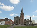
Sint Laureins, church: de Sint-Laurentiuskerk
Watervliet, church: parochiekerk Onze Lieve Vrouwe Hemelvaart


Aalst | Aalter | Assenede | Berlare | Beveren | Brakel | Buggenhout | De Pinte | Deinze | Denderleeuw | Dendermonde | Destelbergen | Eeklo | Erpe-Mere | Evergem | Gavere | Ghent | Geraardsbergen | Haaltert | Hamme | Herzele | Horebeke | Caprijke | Kluisbergen | Kruibeke | Kruisem | Laarne | Lebbeke | Lede | Lierde | Lievegem | Lochristi | Lokeren | Maarkedal | Maldegem | Melle | Merelbeke | Moerbeke | Nazareth | Ninove | Ooster cele | Oudenaarde | Ronse | Sint-Gillis-Waas | Sint-Laureins | Sint-Lievens-Houtem | Sint-Martens-Latem | Sint-Niklaas | Stekene | Temse | Waasmunster | Wachtebeke | Wetteren | Wichelen | Wortegem-Petegem | Zele | Zelzate | Zottegem | Zulte | Zwalm