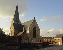
Ooster cele
| Ooster cele | ||
|---|---|---|

|

|
|
|
|
||
| State : |
|
|
| Region : | Flanders | |
| Province : | East Flanders | |
| District : | Ghent | |
| Coordinates : | 50 ° 56 ' N , 3 ° 48' E | |
| Area : | 43.12 km² | |
| Residents: | 13,590 (Jan 1, 2019) | |
| Population density: | 315 inhabitants per km² | |
| Post Code: | 9860 | |
| Prefix: | 09 | |
| Mayor: | Johan Van Durme (CD & V / N-VA) | |
Local government address : |
Gemeentebestuur Oosterzele Dorp 1 9860 Oosterzele |
|
| Website: | www.oosterzele.be | |
Oosterzele is a Belgian municipality in the Flanders region with 13,590 inhabitants (as of January 1, 2019). The municipality consists of the main town and the districts Balegem , Gijzenzele , Landskouter , Moortsele and Scheldewindeke .
The municipality is located 8 kilometers (km) north of Zottegem , 12 km south-southwest of Ghent , 17 km west of Aalst and a good 40 km west-northwest of Brussels .
Oosterzele has a regional train station on the Gent-Oosterzele-Zottegem- Geraardsbergen railway line ; four parts of the municipality along the line have access to a train station (train stations in Landskouter, Moortsele, Scheldewindeke and Balegem, where there are two train stations: Balegem Dorf and Balegem Süd).
geography
Osterzele borders on the following (sub) communities:
a. Wetteren , b. Westrem (Wetteren), c. Bavegem (Sint-Lievens-Houtem), d. Letterhoutem (Sint-Lievens-Houtem), e. Sint-Lievens-Houtem , f. Elene (Zottegem), g. Velzeke-Ruddershove (Zottegem), h. Dikkelvenne (Gavere), i. Baaigem (Gavere), j. Munte (Merelbeke), k. Bottelare (Merelbeke), l. Lemberge (Merelbeke), m. Gontrode (Melle), n. Melle ,
Community structure
Oosterzele consists of a total of six sub-communities, which can be divided into two groups according to size. In the north the smaller sub-communities Gijzenzele, Landskouter and Moortsele, and in the south the larger Balegem, Scheldewindeke and the actual Oosterzele. In addition, there is a larger number of spots / settlement centers distributed over the entire municipality. In alphabetical order these are Anker, Heet, Houw, Kalle, Langemunte, Meerstraat, Smissenbroek, Steenberg and Walzegem.
| # | Naam | Oppervlakte (km²) |
|---|---|---|
| I. | Ooster cele | 11.76 |
| II | Balegem | 12.02 |
| III | Scheldewindeke | 11.84 |
| IV | Moortsele | 3.64 |
| V | Landskouter | 1.96 |
| VI | Gijzenele | 1.87 |
Opm: Cijfers zijn van XX / XX / 20XX
Daughters and sons of the church
- Frans Van De Velde (1909-2002), missionary
- Gustaaf Kardinaal Joos (1923-2004), Kardinaal
- Gerard Vekeman (born 1933), poet
- Johan Van Hecke (* 1954), politician
- Walter Muls (* 1961), politician
- Els De Temmerman (born 1962), journalist, activist
- Tom De Sutter (born 1985), footballer
- Jan Van De Wiele (* 1948), racing cyclist, born in Scheldewindeke


