
Gavere
| Gavere | |||
|---|---|---|---|

|

|
||
|
|||
| State : |
|
||
| Region : | Flanders | ||
| Province : | East Flanders | ||
| District : | Ghent | ||
| Coordinates : | 50 ° 56 ′ N , 3 ° 40 ′ E | ||
| Area : | 31.34 km² | ||
| Residents: | 12,805 (Jan 1, 2019) | ||
| Population density: | 409 inhabitants per km² | ||
| Post Code: | 9890 | ||
| Prefix: | 09 | ||
| Mayor: | Denis Dierick (Open VLD) | ||
Local government address : |
Gemeentebestuur Gavere Market 1 9890 Gavere |
||
| Website: | www.gavere.be | ||

Gavere is a Belgian municipality in the Flanders region with 12,805 inhabitants (as of January 1, 2019). It lies on the banks of the Scheldt between Ghent and Oudenaarde .
history

- Gavere is known for the Battle of Gavere, which was fought in 1453 between the Duke of Burgundy Philip the Good and the rebellious genters, who defended themselves against excessive taxes.
- The oldest fully Dutch-language document was found in Boechaute , a hamlet in Dikkelvenne . The so-called Schöffenbrief ( Schepenbrief ) is a notarial act from the 13th century.
- Charles V raised the land of Gavere to a principality in the 16th century. Lamoraal van Egmont became the first prince.
geography

Oudenaarde is 9 kilometers south, Ghent 13 km north, Aalst 27 km east, Kortrijk 28 km southwest and Brussels about 50 km east. The municipality of Gavere borders on the following municipalities or sub-municipalities: a. Melsen (Merelbeke) , b. Schelderode (Merelbeke), c. Munte (Merelbeke), d. Scheldewindeke (Oosterzele), e. Velzeke-Ruddershove (Zottegem), f. Dikkele (Zwalm), g. Beerlegem (Zwalm), h. Meilegem , i. Nederzwalm-Hermelgem , j. Zingem , k. Huise (Zingem), l. Ouwegem (Zingem), m. Nazareth , n. Eke (Nazareth), o. Zevergem (De Pinte)
Community structure
Gavere consists of six sub-municipalities. Asper is separated from the rest of the community by the Scheldt. Dikkelvenne, Gavere, Semmerzake and, to a lesser extent, Vurste have grown together through the development of rural roads.
There are also two hamlets, Heedwijk and Sint-Janswijk.
| # | Surname | Area km² |
Population (December 31, 2005) |
|---|---|---|---|
| I. | Gavere | 4.36 | 2,819 |
| II | Asper | 5.79 | 4.234 |
| III | Semmerzake | 4.50 | 1,446 |
| IV | Vurste | 4.49 | 1,051 |
| V | Dikkelvenne | 8.99 | 1,889 |
| VI | Baaigem | 3.79 | 565 |
- Source: Municipality of Gavere
Asper
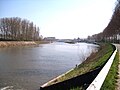
At the height of Asper there is a lock on the Scheldt, on which work began in 2007 and a new route was dug. All work should be completed by 2010. Asper is one of the few places that is separated from its main community by an encroachment on the natural area.
In the direction of Zingem - Steenweg 1 - there is the former poor house. It was donated in 1863 by Sabrina De Groote, who had been Fr. De Bock's widow since 1836. It was originally run by laypeople, only to be taken over by the clergy from Saint Hart van Maria from Nederbrakel.
It served as a retirement home until 1927. It then became the property of the OCMW and is regularly used as an exhibition space by IERMA (Ideas & Expressions of Real Modern Art). Edmond de Perre-Montigny was the architect. On the front facade there is a memorial stone with the text: sticht door Juffrouw Sabina De Groote, huisvrouw van D'heer P. FR. De Bock, overleden te Asper on April 30, 1836 . In Asper, the building is known as the Hof van de gebroeders Vandenberghe , a previous owner of the building.
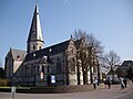
St, Martinus Church, Asper.
The Asper lock (s).

The former poor house.


Demographic development

Sources: NIS and Gavere Municipality; Opm: 1806 up to and including 1970 = censuses; 1976, 2005 = population on December 31st
Semmerzake
The military air traffic control center, which plays an important role in NATO's military air traffic control, is located in the sub-municipality of Semmerzake.

View of Semmerzake

Radar in Semmerzake
_-_general_view.jpg)
_-_Radar.jpg)
Vurste
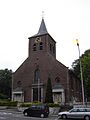
Vurste lies on the border between Sandig and Sandlohmig Flanders, on the Scheldt. The local St. Martin's Church dates from the 14th to 15th centuries, was enlarged in the 16th to 19th centuries and rebuilt between 2000 and 2006. The church has a pointed rectangular tower. The baroque fort Borgwal stands empty and dilapidated in the landscape, but on the heavily walled domain are the new buildings of the Broeders van Liefde who are committed to caring for the mentally handicapped.

St. Martin's Church

Borgwal Castle


Dikkelvenne
St. Petruskirche in Dikkelvenne

Chapel of St. Christiana, where the church stood until 1824.

Memorial stone instead of the old church.

_2.jpg)

The parish and church of Dikkelvenne are named after Saint Peter. The old church collapsed in 1824 and burned down completely. It stood in "De Rotse" not too far from the Scheldt, where there is now a chapel and fountain in honor of St. Christiana. A new St. Oetruskirche was consecrated in 1826. After shelling in World War I , restoration measures were carried out in 1920. The Tarandusmühle located on the border with Beerlegem is worth seeing .
Baaigem
Baaigem has only 565 inhabitants, making it the smallest sub-municipality of Gavere.
Demographic development

- Bron: NIS; Opm: 1806 t / m 1970 = volkstellingen; 1976, 2005 = inwoneraantal op December 31
traffic
The next motorway exits are at Deinze and Kruishoutem in the west and De Pinte in the north on the A14 / E 17 and in Wetteren in the east on the A10 / E 40 .
The municipality has a regional train station on the Oudenaarde - Gavere - Gent railway line.
Others
In the 2007 Tour of Flanders, Gavere was one of the stops. Mayor Hugo Leroy had a controversial appearance on the VRT show Man Bijt Hond in 2009 , which caused a sensation in the national press.
The cyclocross race Cyclocross Gavere has been taking place in the Aspen district since 1983.
Web links
Aalst | Aalter | Assenede | Berlare | Beveren | Brakel | Buggenhout | De Pinte | Deinze | Denderleeuw | Dendermonde | Destelbergen | Eeklo | Erpe-Mere | Evergem | Gavere | Ghent | Geraardsbergen | Haaltert | Hamme | Herzele | Horebeke | Caprijke | Kluisbergen | Kruibeke | Kruisem | Laarne | Lebbeke | Lede | Lierde | Lievegem | Lochristi | Lokeren | Maarkedal | Maldegem | Melle | Merelbeke | Moerbeke | Nazareth | Ninove | Ooster cele | Oudenaarde | Ronse | Sint-Gillis-Waas | Sint-Laureins | Sint-Lievens-Houtem | Sint-Martens-Latem | Sint-Niklaas | Stekene | Temse | Waasmunster | Wachtebeke | Wetteren | Wichelen | Wortegem-Petegem | Zele | Zelzate | Zottegem | Zulte | Zwalm