
Berlare
| Berlare | |||
|---|---|---|---|

|

|
||
|
|||
| State : |
|
||
| Region : | Flanders | ||
| Province : | East Flanders | ||
| District : | Dendermonde | ||
| Coordinates : | 51 ° 1 ′ N , 4 ° 0 ′ E | ||
| Area : | 37.82 km² | ||
| Residents: | 14,958 (Jan 1, 2019) | ||
| Population density: | 396 inhabitants per km² | ||
| Post Code: | 9290 | ||
| Prefix: | 09.052 | ||
| Mayor: | Katja Gabriëls ( Open VLD ) | ||
Local government address : |
Gemeentebestuur Berlare Dorp 2 9290 Berlare |
||
| Website: | www.berlare.be | ||

Berlare (not to be confused with Berlaar ) is a Belgian municipality in the Flanders region on the northern bank of the Scheldt .
It is located in the province of East Flanders and belongs to the Arrondissement of Dendermonde . Berlare has 14,958 inhabitants (as of January 1, 2019) and an area of 37.82 km². Berlare is primarily a farming and residential village.
Geography and traffic
Dendermonde is seven kilometers east, Aalst eight km south, Ghent 20 km west, Brussels 32 km south-east and Antwerp 34 km north-east.
The next motorway exits are at Lokeren in the north on the A14 / E 17 and at Aalst in the south on the A10 / E 40 .
The municipality has a regional train station on the Gent- Wetteren -Berlare-Dendermonde- Mechelen railway line .
Attractions

St. Martin's Church in Berlare
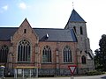
St. Martin's Church in Berlare

Church (de Onze Lieve Vrouw Hemelvaartkerk) in Overmere


- In the village center of Berlare there is still a pillory from the 17th century.
- On the way to Overmere is the listed chapel of Onze-Lieve-Vrouw van Zeven Weeën , built around 1300, rebuilt in the 15th century and enlarged in 1774 in the contemporary Rococo style.
- The Donksee (ndl. Donkmeer) is the largest lake in Flanders (60 ha) and was created from peat pits near the hamlet Donk on the way between Ghent and Dendermonde . It is under nature protection and is a tourist destination and is located on the border between Overmere and Uitbergen.
- The Huize Bareldonk Folklore Museum
- The Madonna Museum (Uitbergen) with a collection of portraits of the Virgin Mary and exhibits on the veneration of Mary in Flanders
- The pastorei with a rococo facade
- The St. Martin's Church
Community structure
In addition to Berlare itself, the municipality of Berlare also includes the sub-municipalities of Overmere and Uitbergen. In between, spread over the three sub-communities, there is still the hamlet of Donk.
| # | Surname | Area (km²) |
Population (31/12/2006) |
|---|---|---|---|
| I. | Berlare | 17.73 | 7,876 |
| II | Uitbergen | 6.48 | 1,980 |
| III | Overmere | 13.72 | 4,504 |
Uitbergen

When it was incorporated into Berlare, Uitbergen had 1605 inhabitants. The Donkmeer lake is partly located in Uitbergen. The St. Peters Church and the former parish hall are worth seeing. The octagonal brick early Gothic crossing tower is the oldest part of the church and its core probably dates back to the 12th century. The two-bay choir was built in sandstone. It is broken through by tweelichtvensters with drielobtracering. The lower church was rebuilt in 1906 under the direction of the architect J. Goethals from Aalst. The interior has a predominantly neo-Gothic appearance. The former town hall from (1927) comes from the hands of Valentin Vaerwyck and stylistically follows that of Zomergem (also built by him). At that time Albert Visart de Bocarmé was Mayor of Uitbergen.
Overmere

In 1331 Overmere and Uitbergen formed a lordship (Heerlijkheid), which was initially owned by the Lords of Dendermonde and later passed on to the Counts of Flanders, who successively gave it to different families: the House of Massemen in the 14th and 15th centuries . The family du Bois (van den Houte) in the 16th century, the family van Coudenhove in the 17th century and the families de Lannoy de Hautpont, de Croy de Beaurainville, van Roosendael en de Heuvel in the 17th and 18th century The rule was congruent with a parish with mother church in Uitbergen and a chapel in Overmere which was replaced by a church in 1350.
On May 24th, 1452 a bloody battle took place near Overmere between the Ghent and the troops of Philip the Good, Duke of Burgundy, hence the name “Strijddam” (Streitdam), which used to refer to the shores of the Donk Lake.
By princely decree of April 18, 1673, at the request of Antoon van Coudenhove, the fiefdom of Uitbergen was divided into two fiefs, Uitbergen and Overmere, but it remained a lay judge's bench.
On October 12, 1798, a peasant uprising began in Overmere, the Boerenkrijg (Peasants' War), which was to spread to all of Flanders, Brabant and the county of Loon . The historical events are kept alive in the local memory. A museum, a street and a statue are dedicated to the Brigands' uprising Voor Outer en Heerd . The latter is a work by Aloïs de Beule , The "12 Oktoberlaan" is located in a residential area southeast of the center of Overmere.
On November 2, 1862, the 14th century church burned down and was replaced by the neo-Gothic Onze-Lieve-Vrouw-Hemelvasrtkerk. The church was built between 1864 and 1866 and consecrated on September 10, 1866 by Bishop Hendrik-Frans Bracq .
Attractions

- The Pa en Gijs peasant war statue
- In addition to the Donksee also the Neudonk (ndl. Nieuwdonk), an artificially created lake near the Donksee.
- The neo-Gothic Church of the Assumption of Our Lady in the center of Overmere, with the high-quality Vereecken organ from 1890.
Festivities
- Every two years Festivaria organizes a play that takes place on the Donksee, with spectators from home and abroad, including members of the Belgian royal family.
Known Overmerer
- Mgr Honoré-Jozef Coppieters (Bishop of Ghent)
- Jan Frans De Lantsheere (writer of the "Leenhof van Dendermonde" (Fronhof?))
- Karel De Gucht (* 1954), VLD politician
- Louis Casimir de Lausnay (Mayor of Overmere and Senator)
- Ernest de Regge (composer)
- Vic Temmerman (sculptor)
- Baron Emile Tibbaut (Representative and Minister)
- Frans Van Laere (civil engineer)
- Emmanuel de Wapenaert ( Chief Alderman of the Land of Dendermonde and Mayor of the City of Dendermonde)
Population development
| year | 1995 | 1996 | 1997 | 1998 | 1999 | 2000 | 2001 | 2002 | 2003 | 2004 | 2005 | 2006 | 2007 | 2008 |
| population | 13,172 | 13,270 | 13,374 | 13,566 | 13,714 | 13,679 | 13,776 | 13,808 | 13,825 | 13,900 | 13,984 | 14.092 | 14,272 | 14,452 |
politics
Mayor of Berlare:
- 1965–1976: Marcel Leys ( PVV )
- 1977–2006: Jan-Willy Van Sande ( CD&V )
- 2007–: Karel De Gucht ( VLD )
Known residents
- Fred De Bruyne (1930–1994), cyclist and sports journalist
- Preben Van Hecke (* 1982), cyclist
- Jarno Van Mingeroet (* 1977), cyclist
- Tjörven De Brul (* 1973), footballer
- Nicolas De Bruyne , player
Web links
Aalst | Aalter | Assenede | Berlare | Beveren | Brakel | Buggenhout | De Pinte | Deinze | Denderleeuw | Dendermonde | Destelbergen | Eeklo | Erpe-Mere | Evergem | Gavere | Ghent | Geraardsbergen | Haaltert | Hamme | Herzele | Horebeke | Caprijke | Kluisbergen | Kruibeke | Kruisem | Laarne | Lebbeke | Lede | Lierde | Lievegem | Lochristi | Lokeren | Maarkedal | Maldegem | Melle | Merelbeke | Moerbeke | Nazareth | Ninove | Ooster cele | Oudenaarde | Ronse | Sint-Gillis-Waas | Sint-Laureins | Sint-Lievens-Houtem | Sint-Martens-Latem | Sint-Niklaas | Stekene | Temse | Waasmunster | Wachtebeke | Wetteren | Wichelen | Wortegem-Petegem | Zele | Zelzate | Zottegem | Zulte | Zwalm