
Erpe-Mere
| Erpe-Mere | |||
|---|---|---|---|

|

|
||
|
|||
| State : |
|
||
| Region : | Flanders | ||
| Province : | East Flanders | ||
| District : | Aalst | ||
| Coordinates : | 50 ° 56 ' N , 3 ° 58' E | ||
| Area : | 34.03 km² | ||
| Residents: | 19,811 (Jan 1, 2019) | ||
| Population density: | 582 inhabitants per km² | ||
| Post Code: | 9420 Aaigem 9420 Bambrugge 9420 Burst 9420 Erondegem 9420 Erpe 9420 Mere 9420 Ottergem 9420 Vlekkem |
||
| Prefix: | 053 | ||
| Mayor: | Hugo De Waele | ||
Local government address : |
Gemeente Erpe-Mere Oudenaardsesteenweg 458 9420 Erpe-Mere |
||
| Website: | www.erpe-mere.be | ||
| Location map |

|
||
| Site plan description | Location of Erpe-Mere in the Aalst arrondissement in the province of East Flanders | ||
| Community plan |

|
||
| Community description | Location of the eight sub-communities in Erpe-Mere | ||

Erpe-Mere is a Belgian municipality in the Denderstreek in the Flanders region . It is located in the province of East Flanders and belongs to the Arrondissement of Aalst . The municipality has 19,811 inhabitants (as of January 1, 2019) and an area of 34.03 km². The municipality has a total of eight sub-municipalities, Aaigem , Bambrugge , Burst , Erondegem , Erpe , Mere , Ottergem and Vlekkem . Bambrugge sub-municipality also has a hamlet: Egem .
history
The community was created in 1975 through the merger of the eight current sub-communities, while the sub-communities Erpe and Mere did not initially agree on the new name for the entire community. Erpe had the largest area, while Mere was more central in the entire area and had more inhabitants. Today's double name was created as a compromise.
geography
The city borders in the north on Lede , in the east on Aalst and Haaltert in the south on Herzele and in the west on Sint-Lievens-Houtem .
Erpe-Mere lies to the north of the foothills of the Flemish Ardennes , in the Dender region. The area north of the N9 (Aalst-Gent) is 10 to 30 m above sea level, the area between N9 and E 40 (Brussel-Gent) is at 25 to 50 meters and the area south of it has hill tops of up to 80 meters high. The best known of them is the Gotegemberg in Mere. Not its height of 68 meters, but its steepness of 18% make it popular as a challenge for racing cyclists. In addition, one has a favorable foresight from the mountain.
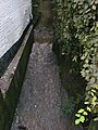
The base area is traversed by two streams in a north-easterly direction, both of which are named Molenbeek. The Molenbeek to the Oberschelde runs through Burst, Bambrugge, Ottergem, Vlekkem, Erondegem en Erpe before it flows into the Scheldt. The Molenbeek-Ter Erpenbeek flows into the Dender .
Even the Romans knew early on that there was white natural stone (called Vlaamse arduin or Lediaanse Steen) in the Steenberg in Bambrugge. It was suitable as a foundation for the masonry of Roman villas , fountains, or as material for columns and capitals in Roman temples. From around the 11th or 12th century, white sandstone was mined in Bambrugge (Steenberg). The most common white natural stone in Brabant was the sandstone extracted there in the 16th to 17th centuries. The quarry was only given up after the Second World War . Today the administrative center of Erpe-Mere is located there.
In the sub-municipalities of Aaigem (municipality of Erpe-Mere) and Heldergem (municipality of Haaltert ) lies the approximately 205 hectare Den Dotter nature reserve .
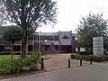
The town hall of Erpe-Mere, zu Steenberg in Bambrugge

The sports hall of Erpe-Mere, zu Steenberg in Bambrugge

The library of Erpe-Mere, to Steenberg in Bambrugge

The Steenberg pond in Bambrugge


traffic
Erpe-Mere has a motorway exit on the A10 / E 40 and a regional train station on the Kortrijk - Oudenaarde - Zottegem - Erpe - Mere - Aalst - Brussels line .
In addition, the N9 (Gentsesteenweg), N442 (Leedsesteenweg) and the N46 (Oudenaardsesteenweg) run through the municipality.

The railway bridge from Erpe over the Oudenaardsesteenweg

The motorway bridge (E 40) from Mere over the Oudenaardsesteenweg


Attractions
- The water tower of the Tussengemeentelijke Maatschappij der Vlaanderen voor Watervoorziening.
Mills
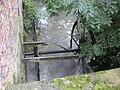
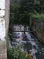
- The mills in the municipality, through which the Dender route south and the Molenbeek route runs, are particularly worth seeing . Due to the geographical situation, there are eleven watermills in Erpe-Mere, most of them in Belgium, seven of them are also legally protected ( monument protection ). One mill was mostly destroyed, but there are still remains of that mill and the miller's house (house of the miller) is still intact. Another mill was converted into a house.
- There is also a windmill on the Koudenberg , one of the highest hills in the municipality . It was reinstalled on its base in 2006 after being restored in 2004 by an atelier in Roeselare. The Kruiskoutermolen was completely restored in 2006 and is ready for use . It can be visited by making an appointment with the tourist service. The mill is a listed building .
| place | Name (s) | address | Type | Protects | info |
|---|---|---|---|---|---|
| Aaigem | Angel moles Molen te Dalhem Molen te Dalme |
Angel moles 1 | Overshot watermill |
|
Formerly a grain mill, oil mill and rocking flax mill, later a grain mill alone |
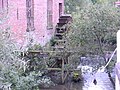
| Aaigem | Ratmolen Waterrat |
Ratmolenstraat 42 | Overshot watermill |
|
Formerly a grain mill and oil mill. Later a grain mill alone |
| Aaigem | Zwingelmolen | Aaigembergstraat 10 | Overshot watermill |
|
Formerly flax vibrating mill, later chicory mill, water wheel removed. Renovated like a house |
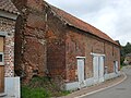
| Bambrugge | Egemmolen Meuleken Tik Tak |
Everdal 21 | Overshot watermill |
|
Kornmühle water wheel removed and mostly destroyed miller house used as country house |
| Bambrugge | Molens Van Sande Kasteelmolen Celindermolen |
Prinsdaal 33 | Overshot watermill |
|
Formerly a grain mill but forced mill. Later common grain mill. Water wheel removed. It is now an industrial grinder |
| Erpe | Cottemmolen | Molenstraat 36 | Overshot watermill |
|
Formerly a grain mill and oil mill. Later a grain mill alone |
| Erpe | Van Der Biestmolen | Dorpsstraat 3 | Overshot watermill |
|
Grain mill |
| Mere | De Graevesmolen | Bosstraat 25 | Overshot watermill |
|
Grain mill and oil mill |
| Mere | Gotegemmolen | Gotegemstraat 1 | Overshot watermill |
|
Grain mill |
| Mere | Kruiskoutermolen Jezuïtenmolen Molen Van Der Haegen |
Schoolstraat | Post windmill with an open post chair |
|
Grain mill |
| Mere | Molen te Broeck 't Hof Schuurke |
Wilgendries 6 | Overshot watermill |
|
Grain mill |
| Ottergem | De Watermeulen | Ruststraat 10-12 | Overshot watermill |
|
Each grain mill and oil mill Later, only grain mill |
gallery

Angel moles in Aaigem
Engelsmolen water wheel in Aaigem

Ratmolen in Aaigem
Ratmolen water wheel in Aaigem

Zwingelmolen in Aaigem
Place where the Zwingelmolen water wheel was in Aaigem
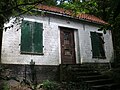
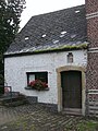
Miller's house from the Egemmolen in Bambrugge

Remnants of the Egemmolen in Bambrugge
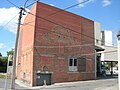
Front view of Molens Van Sande in Bambrugge
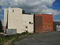
Side view of Molens Van Sande in Bambrugge

Place where the Molens Van Sande waterwheel was in Bambrugge

Front view of the Cottemmolen in Erpe

Side view of the Cottemmolen in Erpe

Water wheel from the Cottemmolen in Erpe

Van Der Biestmolen in Erpe

Van Der Biestmolen water wheel in Erpe

Front view of De Graevesmolen in Mere

Side view of De Graevesmolen in Mere
De Graevesmolen water wheel in Mere

Gotegemmolen in Mere

Gotegemmolen water wheel in Mere

Kruiskoutermolen in Mere
Molen te Broeck in Mere

Molen te Broeck water wheel in Mere
Front view of De Watermeulen in Ottergem

Rear view of De Watermeulen in Ottergem

De Watermeulen water wheel in Ottergem

Interior view of De Watermeulen in Ottergem


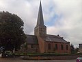
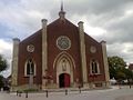
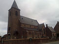
Churches
Aaigem Church

Bambrugge Church
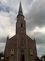
Church of Burst
Erondegem Church

Church of Erpe
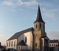
Mere Church
Ottergem Church

Vlekkem Church


_5-10-2018_14-11-37.jpg)


Sports
Erpe-Mere once had seven football clubs that belonged to the Royal Belgian Football Association (KBFV). Four of them are still left today: KRC Bambrugge , KFC Olympic Burst , FC Mere and SK Aaigem . FC Edixvelde went on in FC Mere. FC Oranja Erpe and KFC Olympia Erondegem merged to form KVC Erperondegem , which eventually merged with FC Mere.
The Steenbergcross , the first international cross country race , was held in Bambrugge on the Steenberg domain. Erpe-Mere is the start and finish point of the road bike race Dwars door de Vlaamse Ardennen .
The Belgian "National Clubhouse" of the " Blue Angels " motorcycle club is located in Erpe.
Web links
Individual evidence

Sub-municipalities:
Aaigem |
Bambrugge |
Burst |
Erondegem |
Erpe |
Mere |
Ottergem |
Vlekkem
hamlet:
Egem
List of municipalities in Belgium | Arrondissement of Aalst | East Flanders | Flanders
Aalst | Aalter | Assenede | Berlare | Beveren | Brakel | Buggenhout | De Pinte | Deinze | Denderleeuw | Dendermonde | Destelbergen | Eeklo | Erpe-Mere | Evergem | Gavere | Ghent | Geraardsbergen | Haaltert | Hamme | Herzele | Horebeke | Caprijke | Kluisbergen | Kruibeke | Kruisem | Laarne | Lebbeke | Lede | Lierde | Lievegem | Lochristi | Lokeren | Maarkedal | Maldegem | Melle | Merelbeke | Moerbeke | Nazareth | Ninove | Ooster cele | Oudenaarde | Ronse | Sint-Gillis-Waas | Sint-Laureins | Sint-Lievens-Houtem | Sint-Martens-Latem | Sint-Niklaas | Stekene | Temse | Waasmunster | Wachtebeke | Wetteren | Wichelen | Wortegem-Petegem | Zele | Zelzate | Zottegem | Zulte | Zwalm