
Erondegem
| Erondegem | |||
|---|---|---|---|

|

|
||
|
|||
| State : |
|
||
| Region : | Flanders | ||
| Province : | East Flanders | ||
| District : | Aalst | ||
| Municipality : | Erpe-Mere | ||
| Coordinates : | 50 ° 56 ' N , 3 ° 57' E | ||
| Area : | 3.17 km² | ||
| Post Code: | 9420 | ||
| Prefix: | 053 | ||
| Location map |

|
||
| Site plan description | Location of Erondegem in the municipality of Erpe-Mere in the Arrondissement of Aalst in the province of East Flanders | ||
| Community plan |

|
||
| Community description | Location of Erondegem in Erpe-Mere | ||

Erondegem is a sub-municipality of Erpe-Mere on the Molenbeek in the Denderstreek in the Flanders region . It is located in the southeast of the province of East Flanders and belongs to the Arrondissement of Aalst . The sub-municipality is limited by the sub-municipalities Erpe and Ottergem and the municipal areas of Sint-Lievens-Houtem (sub-municipality Vlierzele) and Lede (sub-municipality Impe). Erondegem has 1628 inhabitants (January 1, 2003) and an area of 3.17 km². The population density is 513 inhabitants / km².
history
Erondegem was first mentioned in a charter from 868 or 869. One wrote in the Eroldingeheim document in pago Bragbattensi . The name comes from a person Erold or Erond. The "gem" refers to that person's home. Hence "Erond his home" (Erondheim → Erondegem). At the beginning of the 19th century the village had 837 inhabitants and on December 31, 1893 it had 963 inhabitants. Erondegem ever had a soccer club KFC Olympia Erondegem in the Royal Belgian Football Association (KBFV).
Sights and gallery
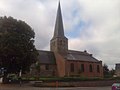
The Sint-Pietersbandenkirche is in Erondegem. Erondegem is part of the Lede dean's office.
The Church of Erondegem, side view

The Church of Erondegem, rear view
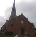
The Church of Erondegem, front view

The rectory of Erondegem
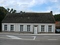
A farmhouse in Erondegem

Beginning of a closed town in Erondegem

End of a built-up area in Erondegem


Sub-municipalities:
Aaigem |
Bambrugge |
Burst |
Erondegem |
Erpe |
Mere |
Ottergem |
Vlekkem
hamlet:
Egem
List of municipalities in Belgium | Arrondissement of Aalst | East Flanders | Flanders