Papegem
| Papegem | ||
|---|---|---|
|
|
||
| State : |
|
|
| Region : | Flanders | |
| Province : | East Flanders | |
| District : | Aalst | |
| Municipality : | Lede | |
| Coordinates : | 50 ° 57 ′ N , 3 ° 56 ′ E | |
| Area : | 0.58 km² | |
| Post Code: | 9340 | |
| Prefix: | 053 | |
| Location map |

|
|
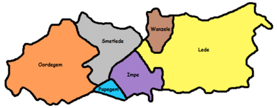
| Site plan description | Location of Papegem in the municipality of Lede in the Arrondissement of Aalst in the province of East Flanders | |
Papegem is a hamlet in the municipality of Lede in the Belgian province of East Flanders in the Denderstreek with an area of 0.58 km². The brook Wellebeek, which flows through the village, flows into the brook Molenbeek . In the past, the Wellebeek was called "Papegemsche beek". Papegem borders on sub-municipalities Oordegem , Smetlede and Impe and the municipalities Sint-Lievens-Houtem (sub-municipality Vlierzele ) and Erpe-Mere (sub-municipality Erondegem ). The Sint-Macharius Chapel is located in Papegem. Papegem is part of the Herzele-Houtem Dean's Office.
history
The Sint-Macharius Chapel was built in 1890 during a typhus epidemic and inaugurated on May 10, 1891. In 1958/1959 an emergency church was built, Macharius became the patron saint. Before the municipalities merged in 1977, Papegem was a residential area of Vlierzele and had no street names.
Today Papegem is a hamlet with around 400 inhabitants. Every year on the first weekend after May 8th there is a nine-day procession and a mass in honor of Saint Macharius.
location

|

|
| Papegem and its border sub-communities | Location of Papegem in Lede |
Attractions
- Sint-Machariuskirche
- Sint-Machariuskapelle to Papegemstraat
- Onze Lieve Vrouwkapelle to Putbosstraat
- Hof te Papegem, Abbey Farm, Papegemstraat 95
- View of Papegem to Papegemstraat, it is outstanding that Papegem like Weiler has sub-municipality boundary signs


