
Bovec
| Bovec | |||
|
|||
| Basic data | |||
|---|---|---|---|
| Country |
|
||
| Historic region | Coastal land / Primorska | ||
| Statistical region | Goriška (Gorica) | ||
| Coordinates | 46 ° 20 ' N , 13 ° 33' E | ||
| height | 434 m. i. J. | ||
| surface | 367.3 km² | ||
| Residents | 3,186 (01/01/2012) | ||
| Population density | 9 inhabitants per km² | ||
| Post Code | 5230 | ||
| License Plate | GO | ||
| Structure and administration | |||
| Website | |||


Bovec ( German : Flitsch , Italian : Plezzo ) is a municipality and its eponymous town in northwestern Slovenia . It is in the Alps region Julian Alps in the valley of Soca .
geography
In the west, the municipality borders directly on Italy ; from Austria it is about 30 kilometers away. Part of it is in the Triglav National Park .
In addition to the main town of Bovec, the following localities belong to the municipality:
- Bavšica (German building seat) ⊙
- Čezsoča (German Ausserdorf) ⊙
- Kal - Koritnica (German: Deutschkall-Krittwald) ⊙
- Lepena (Eng .: Leppen) ⊙
- Log Čezsoški (Eng. Logdorf) ⊙
- Log pod Mangartom (Eng. Brettendorf) ⊙
- Plužna (Eng. Plusnach) ⊙
- Soča (Eng. Sontig) ⊙
- Srpenica (Eng. Serpenitz) ⊙
- Strmec na Predelu (Eng. Stermitz) ⊙
- Trenta (Eng. Trentathal) ⊙
- Žaga (German Saag am Weißenbach) ⊙
The place Bovec lies at an altitude of 434 m. i. J. on the edge of the Bovec Basin, a wide and flat valley basin in which the Koritnica flows into the Soča. Towards Veliki vrh (Eng. Rombon), on the southern flank of which Bovec is located, the place rises slightly.
The places Čezsoča, Kal - Koritnica and Plužna are located in the Bovec basin; Čezsoča on the south, Kal - Koritnica on the east and Plužna on the west edge of the basin. The places Soča and Trenta are located above Bovec in the Sočatal, Log Čezsoški, Žaga and Srpenica downstream. Strmec na Predelu and Log pod Mangartom are in the Koritnica valley. Strmec na Predelu lies at an altitude of about 960 m. i. J. and is thus the highest place in the municipality of Bovec. Lepena lies at the end of a side valley of the Soča, which is traversed by the Lepenjica, which flows into the river of the same name below the village of Soča. Bavšica is located in the valley of the Šunik, which flows into the Koritnica below the Kluže fortress.
history
Archaeological finds - for example in Tolmin and Kobarid - prove a settlement of the Soča valley that goes back to the Hallstatt period .
In Roman times , a paved Roman road ran through the valley, which led over the Predilpass . It connected the provinces of Noricum in the north and Venetia et Histria in the south and was an important trade and military route.
In the 8th century Bovec came under Frankish rule. Subsequently, Bovec was long owned by the Patriarchs of Aquileia . Bovec was first mentioned in a document from 1174 at this time. From 1420, the area of Bovec was under the Republic of Venice , until it was ousted by the Habsburgs in 1509 . In the Austro-Venetian War from 1508 to 1516, Bovec voluntarily supported the side of the Habsburg Emperor Maximilian I , who emerged victorious from the war. Bovec became an independent main team and the Bovec population enjoyed numerous privileges such as tax breaks, forest and grazing rights. In 1751 the main team Bovec lost its independence again.
In 1797 and 1809 French troops under Napoleon Bonaparte invaded Austria through the Soča Valley. Bovec received the status of a canton during these occupation times. Bovec formed its own municipality during the Habsburg era, which belonged to the judicial district of Flitsch . This in turn was part of the Tolmein district and the Prince Counties of Gorizia and Gradisca .
During the First World War , the so-called Soča Front Line ran in the Bovec area from 1915 to 1917 . All citizens had to leave Bovec and the place was completely destroyed during the war. After the war, the Slovene-populated area was divided up; Bovec came under the government of the Italian Kingdom .
After Italy surrendered in World War II , Bovec was occupied by German troops until the end of the war. From 1945 to 1947 the Soča Valley was administered by Anglo-American forces. In 1947 the region was annexed to Yugoslavia . Bovec has been part of independent Slovenia since 1991.
population
About half of the 3200 inhabitants of the village live in the main town Bovec. The other half is distributed among the remaining localities, with Čezsoča and Žaga, each with a good 300 inhabitants, being the next largest localities.
economy
The municipality of Bovec lives mainly from tourism . It has numerous accommodation options in hotels, guest houses and private accommodation. There are also several extensive campsites available. Accommodation options are available for around 5000 visitors. In summer, the natural and clear mountain rivers Soča and Koritnica are tourist destinations where numerous leisure activities such as rafting or kayaking tours are offered. In winter, the (meanwhile rebuilt and modernized) cable car to the Kanin offers good winter sports opportunities .
In addition to tourism, the Bovec region has traditional agriculture, mainly sheep are kept and Bovec is known for its sheep cheese .
To the west of the town is a small industrial site.
Flitscher Klause and Fort Hermann

In the history of Austria-Hungary , Flitsch is mentioned frequently in connection with the Isonzo battles of the First World War . The Italian attackers tried unsuccessfully on this front to penetrate into Austria for years.
There are two Austrian fortresses on the road from Bovec to the Predil Pass . Built 1881-1882 Flitscher cell , slov .: Trdnjava Kluže ( 46 ° 21 '40.9 " N , 13 ° 35' 23.4" O ), is now in good condition and is used for events. Above the Flitscher Klause lies Fort Hermann ( 46 ° 21 ′ 35.8 ″ N , 13 ° 35 ′ 16.7 ″ E ), completed in 1906 , which was severely destroyed in the First World War and is now only preserved as a ruin.
Trivia
The area around Bovec served as the setting for the film The Chronicles of Narnia: Prince Caspian of Narnia . The Bovec river valley offered a similar scenic backdrop to New Zealand , where other parts of the film were shot.
See also
literature
- Marko Simić: On the trail of the Isonzo front. Mohorjeva Hermagoras, Klagenfurt-Laibach-Vienna 2004, ISBN 3-85013-884-4

Bovec

Flitscher Klause, built 1881–1882
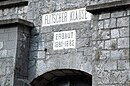
Flitscher Klause, inscription above the portal in the courtyard

Theater performance in the Flitscher Klause

A lake in the vicinity of Bovec


Web links
https://www.isonzofront.de/fotos-erz%C3%A4hlen/1915-1917/fort-hermann-1915/ Photos of Fort Hermann from 1915 and 2019
Individual references and sources
- ^ As of January 1, 2012, Statistical Office of the Republic of Slovenia
- ↑ Julian Alps ( Memento of the original from February 1, 2012 in the Internet Archive ) Info: The archive link was inserted automatically and has not yet been checked. Please check the original and archive link according to the instructions and then remove this notice. (PDF; 14.4 MB). Brochure of the Slovenian Tourist Board
- ↑ Archived copy ( memento of the original dated June 29, 2009 in the Internet Archive ) Info: The archive link was inserted automatically and has not yet been checked. Please check the original and archive link according to the instructions and then remove this notice.
- ↑ Kluže Fortress at slovenia.info
Ajdovščina · Bovec · Brda · Cerkno · Idrija · Canal ob Soči · Kobarid · Miren-Kostanjevica · Nova Gorica · Renče-Vogrsko · Šempeter-Vrtojba · Tolmin · Vipava