
Dreiländereck (Federal Republic of Germany, GDR, Czechoslovakia)


The tri- border region has been the border point of different states over the centuries. Today it is the border point between the federal states of Bavaria and Saxony in Germany and the Czech Republic .
location
The triangle is located near Prex ( Regnitzlosau municipality , Hof district in Bavaria), Tiefenbrunn ( Eichigt municipality , Vogtland district in Saxony) and Trojmezí ( Hranice municipality , Okres Cheb in the Czech Republic).
The southern Rokytnice and its tributary Lesní potok form a natural border . The Bystřina (Mühlbach) flows in Czech territory , there is a rest area with information boards. A walled-in millstone reminds of the hamlet of Císařský Hamr (Kaiserhammer) and the Dolní mlýn (Hofmannsmühle), which last served as an inn for international through traffic. Buildings close to the border were demolished in 1946 to secure the border. Numerous boundary stones have been set up in the area of the Regnitz, including those of the last boundary adjustment from 1844. These are designated architectural monuments . On the German side there is a soldier's grave from the end of the Second World War. On the Czech side there is a stone cross and a tunnel entrance. The border triangle is the destination of numerous hiking trails, including the European long-distance hiking trail E3 and the Kammweg . It is the starting point of the eastern route of the Fichtelgebirgsverein . The Dreiländereck is a stop on the hiking trail to places of fate , which primarily aims to remember border towns that suffered from the border situation during the GDR era, including the desert areas of Hasenreuth , Troschenreuth and Hammerleithen .

Landmark from 1844

Walled-in millstone at the site of the abandoned Hofmannsmühle
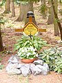
Soldier grave

Stone cross

Tunnel entrance


history
Until 1990 the inner German border between the Federal Republic of Germany and the GDR and the border with Czechoslovakia began at the triangle . It was thus part of the Iron Curtain and only became accessible to pedestrians as a border crossing when the border was opened in 1989/1990.
The border between Austria-Hungary and the German Empire ran there until 1918 . In the 19th century, the state borders of Bavaria , Bohemia and Saxony met there . The Bavarian premiere shows the locations of the boundary stones.
literature
- Dietmar Herrmann: Along the Bavarian-Bohemian border: At the Dreiländereck ( PDF ).
- Alfred Eiber: Hof - The gateway to freedom . Weißenstadt 2017. pp. 41–43.
See also
Web links
Individual evidence
- ↑ District Association of Upper Franconia of the Volksbund Deutsche Kriegsgräberfürsorge eV (ed.): War graves in Upper Franconia . Bayreuth 1985. p. 44.
- ^ Hans Bucka , Oskar Heland : Memorials, soldiers' graves, memorial stones in Rehau and the surrounding area , Hof 1987. P. 58f.
- ↑ Map over the BayernAtlas
Coordinates: 50 ° 19 ′ 5.5 ″ N , 12 ° 6 ′ 3.7 ″ E