
Dreiländerecke (near Sankt Anna am Aigen)

|

|
Coordinates: 46 ° 50 ′ 7.7 ″ N , 15 ° 59 ′ 46 ″ E
The border triangle at Sankt Anna am Aigen , Neuhaus am Klausenbach and Rogašovci , also called Maria-Theresien-Stein , is the border point between Burgenland - Styria - Slovenia .
location
The site is located near the Styrian town of Sichauf , south of the town on the hilltop in the saddle to the Rotterberg (Slov. Kefašev breg , 408 m above sea level / m. I. J.). It lies at 343 m . To the east lies the Burgenland Kalch (Hungarian Mészvölgy ), to the south the Slovenian Ocinje ( Ger . Guizenhof, Hungarian Gedöudvar ).
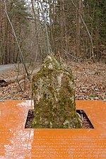
Here is the boundary stone Oe / RS I 277-01, a historical natural stone, the Maria-Theresien-Stein . In fact, this is not the precise tri-border triangle, it marks the Burgenland-Slovenian border, but the stone Oe / RS II 1, a whitewashed stone cuboid, which is not far from about 40 meters north-west above, the actual tri-border area .
The Styrian-Burgenland border runs from the uppermost Kutschenitza shortly before Sankt Anna from southwest to northeast over the Riedel over to the upper Lendva (Limbach, Ledava ) above Kalch and up the Roberbach , the state border from the border triangle towards east over the Rotterberg to the Ledava below Kalch and through the Leinergraben .
The triangle forms the southernmost point of Burgenland.
History and buildings

at the Roberbach estuary

at Romisch - Romischeck
in the Hofwald


Originally the stone marked the border between the Duchy of Steyer (Styria) and the Kingdom of Hungary , which has been running over the Kutschenitza / Kučnica / Kucsenyica to the Riedel between Kapfenstein and Neuhaus since the Middle Ages .
Maria Theresa could - as a woman after the pragmatic sanction of her father Karl VI. defend legitimate claims to the throne in the War of the Austrian Succession 1740–1748, which were initially not recognized by the other powers of Europe . Then she began a comprehensive reform of the state, which also included a consolidation of the territories of her countries and empires . This included precise marking of the borders of the crown lands . The stone here was set in 1756, it is a hewn limestone sediment block. There are several similar stones of the time in the area.

With the collapse of the Habsburg Monarchy and the Treaty of St. Germain in 1919, today's Prekmurje came from Hungary to the SHS state (later Yugoslavia). The stone Oe / RS II 1 is marked accordingly on the Slovenian side with “St. Germain September 10, 1919 “inscribed.
With the Treaty of Trianon in 1920, German West Hungary came to Austria and formed today's Burgenland. As a result, the border point of the three states shifted 10 kilometers north-east to the Tromejnikberg (three-country corner near Sankt Martin an der Raab) .
In the course of the Second World War and the Cold War that followed, the border between neutral Austria and Yugoslavia, which was actually non-aligned, was not freely crossable. Only after the fall of the Iron Curtain in 1989, Slovenia's independence in 1993 and the respective accession to the EU ( Austria 1994 , Slovenia 2004 ), the site became freely accessible after it had been the EU's external border in the meantime .
The Maria-Theresien-Stein was provided with a table and benches, recently the square was redesigned, now a transparent, labeled table forms a border around the stone.
The Eastern Austrian Grenzlandweg (Austrian long-distance hiking trail 07) as well as the Styrian state circular hiking trail (in Sichauf) and the local themed trail Old Border , which connects the existing Theresian stones, run here.
See also
Individual evidence
- ↑ The corner on the Lafnitz near Neustift an der Lafnitz is about 1400 meters to the east
- ↑ a b c d Labeling board of the stone.
- ↑ For illustration see photo 3432750.jpg , on panoramio.com.
- ↑ Daily offers: themed trail "Old Frontier" , naturparkraab.at; Old border. bergfex.at: Hiking trails (both accessed September 17, 2016).