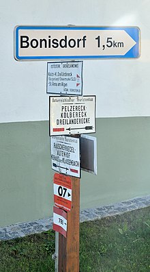
Eastern Austrian border route
| Eastern Austrian border route | |
|---|---|
 Starting point at the Nebelstein |
|
| Data | |
| length | 720 km |
| Markers | red-white-red 07 |
| Starting point | Nebelstein 48 ° 40 ′ 22 ″ N , 14 ° 46 ′ 44 ″ E |
| Target point | Bad Radkersburg 46 ° 41 ′ 12 ″ N , 15 ° 58 ′ 47.5 ″ E |
| Type | Long-distance hiking trail |
| The highest point | Hochwechsel (1743 m) |
| Lowest point | Illmitz (117 m) |
| Level of difficulty | light |
| season | all year round depending on the variant |
The Ostösterreichische Grenzlandweg (also long-distance hiking trail 07 ) is a long-distance hiking trail in Austria from Nebelstein to Bad Radkersburg . It runs through the federal states of Lower Austria , Vienna , Burgenland and Styria . For the hike through the 720 km long path (on the main route), a walking time of around four weeks is estimated. It opened in 1979.
course
The route runs north from Nebelstein, via Weitra and Gmünd to Waidhofen an der Thaya . Continue via Karlstein an der Thaya and Raabs an der Thaya to Hardegg in the Thayatal National Park . The Waldviertel section of the Grenzlandweg, which is identical to the Thayatalweg 630, ends in the town of Retz , which is already in the Weinviertel .
In the Weinviertel the route leads over Haugsdorf , Mailberg and Ernstbrunn to Großrußbach and over the Bisamberg to Langenzersdorf . The federal capital Vienna is crossed along the Danube Island , which is followed for almost its entire length. Through the Lobau you get to the Donau-Auen National Park and finally to Hainburg an der Donau .
At Wolfsthal the Königswarte is crossed, which is considered the most easterly mountain in Austria. Via Kittsee , Nickelsdorf , Frauenkirchen and Illmitz you get to the eastern shore of Lake Neusiedl , which is crossed by boat to Mörbisch . Now the landscape becomes more hilly again, over the Marzer Kogel one arrives at Kobersdorf and Landsee , where the Burgenland variant branches off. The path leads through the Bucklige Welt to its highest point, the Hochwechsel (1743 m).
Hiking now to the south, is only Vorau , after exceeding the Masen Bergs also Hartberg reached. Continue through the East Styrian thermal region via Bad Waltersdorf to Fürstenfeld and via Söchau to Riegersburg . Fehring , Kapfenstein and Sankt Anna am Aigen are the goals of the last section before Bad Radkersburg is reached. A stone on the edge of the Kurpark marks the end point of the Eastern Austrian Grenzlandweg (and at the same time the starting point of the Southern Alpine Path , which can be followed to Sillian).
- Burgenland route
From Landsee there is a separate route in Burgenland, which mostly runs not far from the border with Hungary . It leads to Lockenhaus and the Geschrittenstein , after Rechnitz you reach the Eisenberg an der Pinka wine-growing region . Kohfidisch and Güssing are the next places, after crossing the valleys of Lafnitz and Raab you reach the triangle between Austria, Hungary and Slovenia . In Sichauf near St. Anna am Aigen, the variant meets the main route again.
mark
The path is well signposted with red, white and red markings and path number 07. Sections of the north-south long-distance hiking trail are marked with 607, 707 and 907 (e.g. Retz-Hainburg: 607). In addition to the Burgenland route, there are several comparatively short variants (e.g. to bypass the high change in bad weather), which are marked 07A.
The course of the long-distance hiking trail 07 is determined by the Austrian alpine associations, the contact person and information point is the long-distance hikers section of the Austrian Alpine Association. After hiking the path, a badge can be requested there.
European long-distance hiking trails
The section from Nebelstein to Wolfsthal is part of the European long-distance hiking trail E8 , from Vienna to the Lockenhaus area the path is also part of the European long-distance hiking trail E4 . However, both long-distance hiking trails are rarely given additional markings or boards.
literature
- Erika Käfer, Fritz Käfer: Austrian long-distance hiking trail 07. From the northern forest to the Eastern Styrian wine and volcanic mountains . Ed .: Austrian Alpine Association, Section Long-Distance Hikers. Graz November 2018.
- Hans Hödl , Werner Rachoy, Robert Wurst: On Austria's great roads. Long-distance hiking trail 01 - 10 . Styria, Graz 1984, ISBN 3-222-11540-0 .
Web links
- Austrian Alpine Association: Ostösterreichischer Grenzlandweg 07 in the Long-Distance Hikers section (accessed on February 21, 2020)
- Waymarked Trails: Course of the Ostösterreichischen Grenzlandweg (main route) (accessed on February 21, 2020)

