Masenberg
| Masenberg | ||
|---|---|---|
|
Masenberg von Grafendorf in the east |
||
| height | 1261 m above sea level A. | |
| location | Styria , Austria | |
| Mountains | Joglland , mountain range east of the Mur | |
| Dominance | 11.6 km → Rabenwaldkogel | |
| Notch height | 346 m ↓ Zissertaverne | |
| Coordinates | 47 ° 20 '58 " N , 15 ° 52' 30" E | |
|
|
||
| rock | predominantly mica slate | |
The Masenberg is a mountain in the outskirts east of the Mur in Styria . With a height of 1261 m above sea level. A. it forms one of the last high foothills of the Central Alps to the east and with its elongated mountain ridge separates the Vorauer basin in the north and the Lafnitz valley in the east. In the south of the Masenberg are the places Pöllauberg and Pöllau .
The summit ridge is a wooded ridge that stretches for about one kilometer from the Pongratzer Kogel ( 1248 m ) in the east to the highest point in the west, also called Masenberg (or Grätzer Kogel ). To the north of the Pongratzer Kogel lies the elevation called Pucheggberg ( 1144 m ). The Masenberg massif continues southeast to the Ringkogel ( 789 m ) near Hartberg . From the Masenberg you have a view of large parts of Eastern Styria and central Burgenland .
geology
The Masenberg consists mainly of mica schist , with deposits of granite, eye gneiss and amphibolite and is located on the edge of the Styrian Basin , a peripheral bay of the Pannonian Basin .
Surname
As early as the 12th century, a Marchward vom Masenberg is mentioned as the owner of the castle Reitau .
Summit area
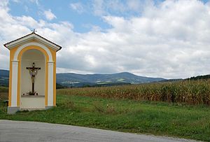
The Kernstockhaus, named after Ottokar Kernstock , which was formerly owned by the Neunkirchen section of the ÖTK , is located directly on the highest peak . After that, the hut was a private inn. Since 1987, the summit area has been owned by the Wilfinger family of hoteliers, who currently (2008) run the hotel as the Hildegard von Bingen Naturhaus on the Masenberg power place . The same hotel chain from Eastern Styria also acquired the chapel from Hof in Kirchberg an der Raab , which was offered on eBay in 2008 , demolished it and had it rebuilt as a lucky chapel on the Masenberg .
To the northeast of the summit, already in the municipality of Schachen , there is a small ski area with what used to be two tow lifts, only one of which still exists. Immediately next to it is a new ski hut and restaurant that is operated all year round.
Filial church St. Pangrazen
On the eastern slope of the Masenberg, at an altitude of 925 m , the small church of St. Pangrazen rises in the district of Pongratzen in the municipality of Stambach . It was first mentioned in a document in 1544, but its exact year of origin and the reason for its construction can no longer be traced today. In contrast to many other Catholic churches, the church is oriented with its main axis and the altar to the west. A mass is read in the church on May 12th (St. Pankratiustag). The Pankratziusweg, named after the church, connects Vorau via St. Pankratzen with Pöllauberg as a pilgrimage route . Next to the church is the Mesnerhäusl, which is used as an inn on weekends.
Web links
swell
- ↑ Pöllauer Hirschbirne. Traditional cultivation of the Hirschbirne variety on orchards in the area around Pöllautal, Styria. Retrieved September 14, 2019 .
- ^ Landesmuseum Joanneum , Geology and Paleontology
- ↑ Information board on 3-Schlösser Weg
- ↑ http://www.wilfinger-hotels.at/seminare/kraftort_masenberg.pdf
- ↑ http://www.kirchberg-raab.eu/Hofer_Kapelle_auf_Ebay.616.0.html
- ↑ Pictures of the chapel transfer
- ↑ Information notice on the church itself, excerpt from the commemorative publication: 450 years of the St. Pankrazen branch church


