Joglland
| Joglland | |
|---|---|
|
Joglland near Fischbach |
|
| Highest peak | Rabenwaldkogel ( 1280 m above sea level ) |
| location | Styria , Austria |
| part of | Styrian peripheral mountains |
| Classification according to | Landscape structure of Styria R.10 |
| Coordinates | 47 ° 26 ' N , 15 ° 52' E |
| Type | Low mountain range |
| rock | Slate , gneiss |
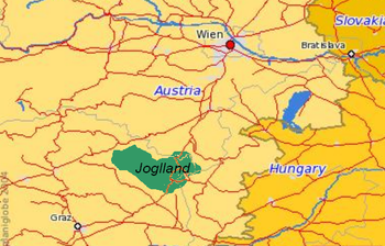
The Joglland is a densely wooded mountainous area in the north-eastern Styria in the districts Hartberg-Fürstenfeld and Weiz . Today the area forms the Joglland – Waldheimat tourism region (Joglland power donation villages) .
It supposedly got its name from " Jakob ", who in this area is often twisted into "Joggl" or "Jackl". In literary terms, this area was described by the Styrian poet Peter Rosegger , who grew up on the Alpl (municipality of Krieglach) as the son of poor mountain farmers.
Location and landscape
Joglland is located in Eastern Styria between Wechsel , the upper Feistritztal , Safenbach and the Hartberg - Friedberg area . It forms a sub-group of the peripheral mountains east of the Mur .
The Semmering region lies to the north, and the Bucklige Welt region (Lower Austria) to the northeast . To the northwest are the Fischbach Alps , and behind them the lower Mürz Valley . The Grazer Bergland stretches towards the west and south-west . In the south follows the eastern Styrian hill country , and towards the south-east the southern Burgenland - the latter both already part of the Alpine foothills in the south-east towards Pannonia .
The highest peaks of this area with low mountain range character are next to the peaks of the Wechselmassif - such. B. Hochwechsel ( 1742 m ), Herrenstein ( 1448 m ) and Hochkogel ( 1314 m ) - the wild meadows ( 1254 m ), the Masenberg ( 1261 m ) and the Rabenwaldkogel ( 1281 m ).
The Feistritz and Lafnitz area is drained .
nature
Closed spruce and red pines predominate, but there are also island-like red beech stands .
Of particular ornithological interest are the comparatively good breeding occurrences of the black stork and the corn corn .
The following protected areas in nature and landscape protection are partially or entirely in Joglland:
- European protected area parts of the Styrian Jogl and Wechselland
- Landscape protection area Waldbach-Vorau-Hochwechsel
- Sommersguter Moor nature reserve
colonization
Settlement came mainly from the Augustinian Canons of Vorau, founded in the 12th century . Vorau and Pöllau are still the cultural centers of the area today.
Joglland – Waldheimat tourism region and LEADER region, Joglland power donation villages
| Joglland – Waldheimat / Joglland strength donation villages | |
|---|---|
| legal form | Community association |
| purpose | Regional interest group |
| founding | 1995 (LEADER), 2006 (TV)
|
| Members | 13 municipalities |
| Organization type | LEADER region , tourism association |
| Website |
www.joglland-waldheimat.at www.joglland.at |
From an economic point of view, tourism is the main source of income for the region, which is relatively poorly developed in terms of transport, in addition to agriculture, so in 2006 the largest tourism association in Styria, Joglland - Waldheimat (in relation to Rosegger), which straddles the borders of the Joglland in the real sense of the word, was established here Northwest to the Waldheimat , the core region of the Fischbacher Alps, towards the Murtal. The main focus here is on gentle tourism with a few small winter sports areas and extensive hiking regions. Another tourism project is the adventure exhibition Kräftereich St. Jakob im Walde , which opened in summer 2008 and has the "realm of powers, myths and realities" as its theme. This region is also represented as the Joglland power donation village in the LEADER program, the EU's structural funding initiative .
The association and the Leader region originally included the 21 communities: Wenigzell, Fischbach, Miesenbach, Vorau, Mönichwald, St. Jakob im Walde, Ratten, Birkfeld, Strallegg, St. Kathrein aH, Rettenegg, Waisenegg, Waldbach, Puchegg, Riegersberg, Schachen, Vornholz, Gschaid, Eichberg, Stambach, Grafendorf.
As part of the municipal structural reform in Styria , some municipalities were merged with others from 2015, so there are now the 13 municipalities Wenigzell , Fischbach , Miesenbach , Vorau , St. Jakob im Walde , Ratten (Styria) , Birkfeld , Strallegg , St. Kathrein aH , Rettenegg , Waldbach-Mönichwald , Rohrbach an der Lafnitz , Grafendorf .
Web links
Individual evidence
- ↑ http://www.kraeftereich.at
- ↑ Leaderregion Kraftspendedörfer Joglland ( Memento of the original from April 4, 2016 in the Internet Archive ) Info: The archive link was inserted automatically and has not yet been checked. Please check the original and archive link according to the instructions and then remove this notice. , joglland-waldheimat.at
- ↑ IG Kraftspendedörfer Joglland ( memento of the original from July 25, 2017 in the Internet Archive ) Info: The archive link has been inserted automatically and has not yet been checked. Please check the original and archive link according to the instructions and then remove this notice. , netzwerk-land.at
- ↑ Die Kraftspendedörfer ( page no longer available , search in web archives ) Info: The link was automatically marked as defective. Please check the link according to the instructions and then remove this notice. , joglland-waldheimat.at


