
Safeners
| Safeners | ||
 The safen near Bad Blumau |
||
| Data | ||
| location | Styria | |
| River system | Danube | |
| Drain over | Lafnitz → Raab → Moson-Danube → Danube → Black Sea | |
| origin | At Sebersdorf by the confluence of Hartberger Safen and Pöllauer Safen 47 ° 10 '48 " N , 16 ° 0' 13" E |
|
| Source height | 290 m above sea level A. | |
| muzzle | at Deutsch Kaltenbrunn in the Lafnitz coordinates: 47 ° 5 ′ 16 ″ N , 16 ° 5 ′ 11 ″ E 47 ° 5 ′ 16 ″ N , 16 ° 5 ′ 11 ″ E |
|
| Mouth height | 255 m above sea level A. | |
| Height difference | 35 m | |
| Bottom slope | 2.5 ‰ | |
| length | 13.9 km | |
| Catchment area | 380.6 km² | |
| Communities | Bad Waltersdorf , Bad Blumau | |
The Safen is a river in Styria in Austria . Safen is created by the confluence of the Hartberger Safen and the Pöllauer Safen in Sebersdorf .
The Safen flows through Bad Waltersdorf , Leitersdorf bei Hartberg , Schwarzmannshofen , Bad Blumau , Bierbaum an der Safen and Safenau .
It flows into the Lafnitz at Deutsch Kaltenbrunn , which forms the border between Styria and Burgenland and belongs to the catchment area of the Danube .
The earliest written testimony is from 860 and reads "ad Sabnizam". The name goes back to the Slovenian zaba (frog / toad).
The stream was regulated in the 1960s.
In Bad Blumau there is a small hydroelectric power station and the natural thermal park, which connects the Hotel Rogner Bad Blumau, designed by Friedensreich Hundertwasser, with the town. A fish lift was built at the small hydropower station in Bad Blumau. In the course of monitoring, around 4,500 fish from 25 fish species were detected.
Picture gallery

Floodplain of the Safen after flooding at the Hotel Rogner Bad Blumau
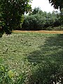
Meadow that has fallen dry after flooding. After a thunderstorm, the river is still clouded by the earth that was carried along.
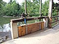
Weir of the Bad Blumau electrical works

Safen below the Bad Blumau electrical works

Heron in the outlet area of the Bad Blumau electrical works

Safen confluence with the Lafnitz


Web links
Individual evidence
- ↑ Digital Atlas of Styria: Waters & Water Information. (No longer available online.) State of Styria , archived from the original on June 15, 2012 ; accessed on September 10, 2017 . Info: The archive link was inserted automatically and has not yet been checked. Please check the original and archive link according to the instructions and then remove this notice.
- ↑ Extract from the digital Styrian body of water index. State of Styria , accessed on September 10, 2017 .
- ↑ BMLFUW (ed.) : List of areas of the river areas: Leitha, Rabnitz and Raab areas. In: Contributions to Austria's hydrography, issue No. 63, Vienna 2014, pp. 29/69. PDF download , accessed July 6, 2018.
- ↑ Fritz Frhr. Lochner von Hüttenbach: On the name property of the early Middle Ages in Styria (= magazine of the Historical Association for Styria . Volume 99 ). Böhlau Verlag, Vienna 2008, p. 35 ( historerverein-stmk.at [PDF; 16.9 MB ]).