
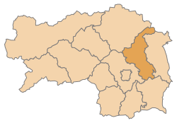
Weiz district
| location | |
|---|---|
 .svg) |
|
| Basic data | |
| state | Styria |
| NUTS III region | AT-224 |
| Administrative headquarters | Wheat |
| surface | 1098 km² |
| Residents | 90,654 (January 1, 2020) |
| Population density | 83 inhabitants / km² |
| License Plate | WZ |
| District Commission | |
| District Captain | Rüdiger Taus |
| website |
www.bh-weiz. steiermark.at |
| map | |
  |
|
The district of Weiz is a political district of the state of Styria with an area of 1,097.86 km².
It borders on the following neighboring districts:
- in the south to the district of Südoststeiermark
- in the west to the Graz-Umgebung district ,
- in the north to the Bruck-Mürzzuschlag district ,
- in the east to the Hartberg-Fürstenfeld district
and in the northeast forms the Styrian border against the Lower Austrian district of Neunkirchen .
history
The Weiz district was divided into 54 municipalities up to 2014 , including two towns and eight market communities.
As part of the municipal structural reform in 2014/15 , the number of municipalities was reduced to 31 from 2015. The municipal areas of Tyrnau and Tulwitz have been reclassified from the Graz-Umgebung district to the Weiz district through the amalgamation of communities across district borders . The boundaries of the districts have been changed so that the new municipalities are completely in one district.
Since January 2015 the district consists of 31 municipalities:
- Albersdorf-Prebuch, Anger, Birkfeld, Fischbach, Fladnitz an der Teichalm, Floing, Gasen, Gersdorf an der Feistritz, Gleisdorf, Gutenberg-Stenzengreith, Hofstätten an der Raab, Ilztal, Ludersdorf-Wilfersdorf, Markt Hartmannsdorf, Miesenbach near Birkfeld, Mitterdorf the Raab, Mortantsch, Naas, Passail, Pischelsdorf am Kulm, Puch bei Weiz, Ratten, Rettenegg, Sankt Kathrein am Hauenstein, Sankt Kathrein am Offenegg, Sankt Margarethen an der Raab, Sankt Ruprecht an der Raab, Sinabelkirchen, Strallegg, Thannhausen, Weiz .

Administrative division
- The population in the table is from January 1st, 2020. Regions are small regions of Styria .
| local community | location | Ew | km² | Ew / km² | Judicial district | region | Type
|
photo | Metadata |
|---|---|---|---|---|---|---|---|---|---|
Albersdorf-Prebuch
|

|
2,206 | 14.15 | 156 | Wheat | 069 Gleisdorf | local community
|

|
According to code: 61701 |
Anger
|

|
3,995 | 53.84 | 74 | Wheat | 059 Anger (Anger-Puch) | market community
|

|
Acc. To code: 61756 |
Birkfeld
|

|
4,958 | 89.78 | 55 | Wheat | 033 Birkfeld | market community
|

|
According to code: 61757 |
Fischbach
|

|
1,524 | 61.57 | 25th | Wheat | 025 Fischbach Alps | local community
|

|
Acc. To code: 61708 |
Fladnitz at the Teichalm
|

|
1,790 | 66.51 | 27 | Wheat | 020 Almenland Nature Park | local community
|

|
Acc. To code: 61758 |
Floing
|

|
1,204 | 13.28 | 91 | Wheat | 059 Anger (Anger-Puch) | local community
|

|
Acc. To code: 61710 |
Gases
|

|
891 | 33.92 | 26th | Wheat | 020 Almenland Nature Park | local community
|

|
Acc. To code: 61711 |
Gersdorf an der Feistritz
|

|
1,699 | 30.07 | 57 | Wheat | 065 Kulmland (Kulmland region) | local community
|

|
Acc. To code: 61759 |
Gleisdorf
|

|
10,926 | 38.67 | 283 | Wheat | 069 Gleisdorf | urban community
|

|
According to code: 61760 |
Gutenberg-Stenzengreith
|

|
1,623 | 22.92 | 71 | Wheat | 109 wheat | local community
|

|
According to code: 61761 |
Hofstätten on the Raab
|

|
2,310 | 15.25 | 151 | Wheat | 069 Gleisdorf | local community
|

|
According to code: 61719 |
Ilztal
|

|
2,180 | 22.48 | 97 | Wheat | 065 Kulmland (Kulmland region) | local community
|

|
According to code: 61762 |
Ludersdorf-Wilfersdorf
|

|
2,463 | 12.81 | 192 | Wheat | 069 Gleisdorf | local community
|

|
Acc. To code: 61727 |
Hartmannsdorf market
|

|
2,946 | 29.2 | 101 | Wheat | - | market community
|

|
According to code: 61716 |
Miesenbach near Birkfeld
|

|
678 | 14.72 | 46 | Wheat | 033 Birkfeld | local community
|

|
Acc. To code: 61728 |
Mitterdorf on the Raab
|

|
2,101 | 21.02 | 100 | Wheat | 109 wheat | local community
|

|
Acc. To code: 61729 |
Mortantsch
|

|
2.184 | 17.47 | 125 | Wheat | 109 wheat | local community
|

|
According to code: 61730 |
Naas
|

|
1,351 | 20.78 | 65 | Wheat | 109 wheat | local community
|

|
According to code: 61731 |
Passail
|

|
4,414 | 84.91 | 52 | Wheat | 020 Almenland Nature Park | market community
|

|
According to code: 61763 |
Pischelsdorf am Kulm
|

|
3,679 | 28.14 | 131 | Wheat | 065 Kulmland (Kulmland region) | market community
|

|
Acc. To code: 61764 |
Puch near Weiz
|

|
2,042 | 24.76 | 82 | Wheat | 059 Anger (Anger-Puch) | local community
|

|
Acc. To code: 61740 |
Rats
|

|
1.103 | 28.8 | 38 | Wheat | 025 Fischbach Alps | local community
|

|
Acc. To code: 61741 |
Rettenegg
|

|
712 | 78.53 | 9.1 | Wheat | 025 Fischbach Alps | local community
|

|
Acc. To code: 61743 |
St. Kathrein am Hauenstein
|

|
633 | 19.3 | 33 | 025 Fischbach Alps | - | local community
|

|
Acc. To code: 61744 |
Sankt Kathrein am Offenegg
|

|
1,073 | 40.41 | 27 | Wheat | 020 Almenland Nature Park | local community
|

|
According to code: 61745 |
St. Margarethen on the Raab
|

|
4.110 | 43.02 | 96 | Wheat | - | market community
|

|
Acc. To code: 61746 |
Sankt Ruprecht an der Raab
|

|
5,419 | 41.08 | 132 | Wheat | 109 wheat | market community
|

|
According to code: 61765 |
Sinabelkirchen
|

|
4,279 | 37.19 | 115 | Wheat | - | market community
|

|
Acc. To code: 61748 |
Strallegg
|

|
1.917 | 42.23 | 45 | Wheat | 033 Birkfeld | local community
|

|
Acc. To code: 61750 |
Thannhausen
|

|
2,447 | 33.43 | 73 | Wheat | 109 wheat | local community
|

|
Acc. To code: 61751 |
Wheat
|

|
11,797 | 17.49 | 674 | Wheat | 109 wheat | urban community
|

|
Acc. To code: 61766 |
Population development

Web links
Individual evidence
- ↑ Ordinance of the Styrian Provincial Government of 10 July 2014, with which the Styrian District Authority Ordinance is changed. Provincial Law Gazette for Styria dated September 10, 2014. No. 99 Volume 2014. ZDB -ID 705127-x .
- ↑ Statistics Austria - Population at the beginning of 2002–2020 by municipalities (area status 01/01/2020)
Bruck-Mürzzuschlag |
Deutschlandsberg |
Graz |
Graz area |
Hartberg-Fürstenfeld |
Leibnitz |
Leoben |
Liezen |
Murau |
Murtal |
Southeast Styria |
Voitsberg |
Weiz
Political Expositur:
Gröbming
Former districts:
Bruck an der Mur |
Feldbach |
Fürstenfeld |
Hartberg |
Judenburg |
Knittelfeld |
Mürzzuschlag |
Radkersburg |
Stainz
Former branches:
Bad Aussee |
Iron ore |
Friedberg |
Fürstenfeld |
Knittelfeld |
Mariazell |
Mürzzuschlag |
Radkersburg |
Sankt Gallen |
Voitsberg
Coordinates: 47 ° 13 ' N , 15 ° 38' E