Mürzzuschlag district
| Former district of Mürzzuschlag | |
|---|---|
 |
|
| Basic data | |
| Country | Austria |
| state | Styria |
| Capital | Mürzzuschlag |
| surface | 848.9 km² |
| Residents | 39,956 (January 1, 2012) |
| density | 47 inhabitants per km² |
| ISO 3166-2 | AT-6 |
Cars: MZ
|
|
Coordinates: 47 ° 34 ' N , 15 ° 32' E
The former political district of Mürzzuschlag was in the north-east of Styria . The license plate was MZ.
history
As part of the reorganization of the Styrian district authorities , the district was merged with the Bruck an der Mur district to form the Bruck-Mürzzuschlag district on January 1, 2013 .
Administrative division
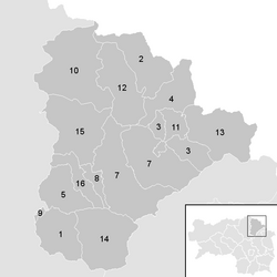
The Mürzzuschlag district was divided into 16 communities , including two towns and five market communities.
Population development

Former district captains
- Franz Hervay von Kirchberg (1903)
- Count Rudolf Schönfeld (1904)
- Heinrich Lorang von Schottendorf (1906)
- Count Alois Montecuccoli (1918)
- Camillo Vöres-Valtin (1919)
- Franz Porsche (1931)
- Albert Wöhrer (1932)
- Alexander Smekal (1933)
- Erich Duman (1934)
- Rudolf Klug (1938)
- Alfred Schachner-Blazizek (1945)
- Julius Reichl (1954)
- Hans Bauer (1955)
- Heribert Uray (1964)
- Anton Maier (1977)
- Gerhard Ofner (1987)
- Gabriele Budiman (2006–2012)
literature
- EU regional management for eastern Upper Styria, Wilhelm Schrenk (supervision): Mürzzuschlag planning region. Project manual and updated short version of the regional development model, status: May 2000, on behalf of the regional planning advisory board Mürzzuschlag, Graz 2000 ( pdf , raumplanung.steiermark.at).
Web links
Commons : District Mürzzuschlag - collection of pictures, videos and audio files
Individual evidence
- ↑ ORF.at (April 20, 2012): Further district mergers: 6 become 3 , accessed on April 20, 2012
- ^ District captains , accessed on March 12, 2017.

