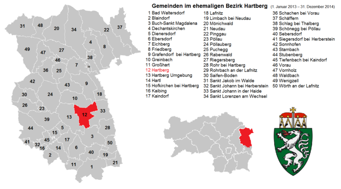
Hartberg district
| Former district of Hartberg | |
|---|---|
 |
|
| Basic data | |
| Country | Austria |
| state | Styria |
| Capital | Hartberg |
| surface | 955.7 km² |
| Residents | 66,617 (January 1, 2012) |
| density | 70 inhabitants per km² |
| ISO 3166-2 | AT-6 |
Cars: HB
|
|
Coordinates: 47 ° 21 ' N , 15 ° 53' E
The political district of Hartberg was an administrative district of the Austrian state of Styria . It bordered the Weiz district in the west and northwest , the former Fürstenfeld district in the south and forms the Styrian border to the north and east against the Oberwart and Güssing districts (in the east) and Neunkirchen , as well as the Wiener Neustadt-Land district (in the north ).
history
As part of the reorganization of the Styrian district authorities , the district was merged with the Fürstenfeld district to form the Hartberg-Fürstenfeld district on January 1, 2013 . Until December 31, 2012, the Hartberg district comprised approx. 66,600 inhabitants with an area of approx. 960 km². The official license plate was HB .
Administrative division
The Hartberg district was divided into 50 communities , including two towns and seven market communities.
Community structure reform
In 2011, the Styrian state government committed itself to considerably reducing the number of districts and municipalities as part of an administrative reform. The trigger for these efforts is the high level of debt in the federal state and the public sector's need to make substantial savings.
On November 20, 2011, the eligible voters of the communities Dienersdorf , Ebersdorf , Großhart , Hartl , Hofkirchen bei Hartberg , Kaindorf and Tiefenbach bei Kaindorf voted on whether these seven communities should be merged into one large community. With a total turnout of 65.66%, 3351 valid votes were counted. Of these, 436 voters (13.01%) voted for a merger of the municipalities, while 2915 voters (86.99%) voted against a merger.
On January 1, 2013, the municipalities of Buch-Geiseldorf and Sankt Magdalena am Lemberg became the municipality of Buch-St. Magdalena folded.
See also
literature
- Fritz Posch: History of the administrative district Hartberg. Volumes 1-3. Great historical regional studies of Styria. Styrian Provincial Archives (including), Graz / Hartberg 1978–1990, ZDB -ID 568794-9 , OBV .
- Erich Grabenhofer: The Styrian district of Hartberg. A geographical consideration with special emphasis on the demographic-economic structural change since the Second World War. Thesis. University of Graz, Graz 1988, OBV .
- Johann Riegler, Irmgard Dober (Red.): Hartberg. The district in old postcards. Austria's districts in old postcards. Ueberreuter, Vienna 2006, ISBN 978-3-8000-7258-3 .
- Veronika Katrin Kulmer: An economic analysis of urban sprawl based on the case study of the Hartberg district. Master thesis. University of Graz, Graz 2009. - Full text online (PDF; 3.4 MB) .
- Stibor Stephan: Hartberg 1918–1938. A study on politics, culture, economy and society of a region. (History of the Styrian administrative district Hartberg). Dissertation. University of Graz, Graz 2010. - Full text online (PDF; 30 MB) .
Web links
Individual evidence
- ↑ ORF.at (April 20, 2012): Further district mergers: 6 become 3 , accessed on April 20, 2012
- ↑ Wiener Zeitung : A total of 87 percent of the Eastern Styrian communities surveyed were against merger , November 20, 2011. ( Memento of November 24, 2011 in the Internet Archive )
- ↑ Stmk LGBl 2012/106. (PDF; 1.3 MB) Retrieved November 20, 2012 .


