Kaindorf (Styria)
|
market community Kaindorf
|
||
|---|---|---|
| coat of arms | Austria map | |
|
|
||
| Basic data | ||
| Country: | Austria | |
| State : | Styria | |
| Political District : | Hartberg-Fürstenfeld | |
| License plate : | HF (from 1.7.2013; old: HB) | |
| Surface: | 28.01 km² | |
| Coordinates : | 47 ° 14 ' N , 15 ° 55' E | |
| Height : | 342 m above sea level A. | |
| Residents : | 2,994 (January 1, 2020) | |
| Postal code : | 8224 | |
| Area code : | 03334 | |
| Community code : | 6 22 72 | |
| NUTS region | AT224 | |
| Address of the municipal administration: |
Kaindorf 29 8224 Kaindorf |
|
| Website: | ||
| politics | ||
| Mayor : | Thomas Teubl ( ÖVP ) | |
|
Municipal Council : (2020) (15 members) |
||
| Location of Kaindorf in the Hartberg-Fürstenfeld district | ||
| Source: Municipal data from Statistics Austria | ||
Kaindorf (post office means: Kaindorf bei Hartberg ) is a market town with 2994 inhabitants (as of January 1, 2020) in the judicial district of Fürstenfeld and in the political district of Hartberg-Fürstenfeld in Eastern Styria ( Austria ).
Since January 1, 2015, it has been merged with the communities of Dienersdorf and Hofkirchen bei Hartberg as part of the Styrian community structure reform , the new community continues the name "Kaindorf".
geography
Kaindorf is located in the east Styrian hill country , about eight kilometers southwest of the district capital Hartberg and about 40 km northeast of the provincial capital Graz . The Pöllauer Safen flows through the community and takes up the Tiefenbach in the south of the community. In the north, the market town is bounded by the Dombach. The extreme south belongs to Nörning.
Community structure
The municipal area comprises four localities or cadastral communities of the same name (population: as of January 1, 2020; area 2016):
- Dienersdorf (731 Ew., 707.08 ha) with Altenberg, Dienersberg, Großbach, Haselberg, Hochstraße, Kaag, Kruckental, Unterwinzenbach and Winzenbach
- Hofkirchen near Hartberg (690 Ew.), KG Hofkirchen (662.43 ha) with Dreihöf, Edelbach, Edelberg, Enggasse, Hinterbüchl, Moihöf, Rieglhöf, Sankt Stefan and Vockenberg
- Kaindorf (1169 Ew., 524.50 ha) with Brunnfeld and Hinterbüchl
- Kopfing near Kaindorf (404 Ew., 892.82 ha) with Auffenberg, Gießhübl, Holzhöf, Kopfing near Kaindorf-Dispersed Houses, Lebenhöf, Marbach, Nörning and Pirchegg
Incorporations
- In 1968 the independent municipality of Kopfing was incorporated.
- In 2015, as part of the structural reform of the state of Styria, the independent communities Dienersdorf, Hofkirchen and Kaindorf merged to form the new community Kaindorf.
Neighboring communities
| Pöllau | Hartberg surroundings | Hartberg surroundings |
| Pöllau |

|
Ebersdorf |
| Hartl | Hartl | Ebersdorf |
history
Kaindorf was founded around 1128 by Konrad von Safen, who had recently received the area of today's Kaindorf parish from the Styrian Margrave Leopold the Strong . Kaindorf is first mentioned in 1255 as Chundorf (the village of Chuno or Konrad). After the Lords of Safen died out in the 13th century, their property came to the Lords of Stubenberg , Neuberg and Stadeck and the Teuffenbacher.
In 1523 the place was first mentioned in a document with the current name Khaindorff .
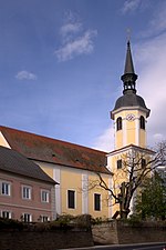
The church of St. Jakob is first mentioned in 1313 as a vicariate church. The current parish church was built at the beginning of the 18th century using older components.
Kaindorf was located in the frequently visited border area and was destroyed by the Hungarians in 1418 , by the Turks in 1532 and by the Haidukes in 1605 . On July 25, 1704 the village was set on fire by the Kuruc . Kaindorf only developed from a purely agricultural settlement into a commercial center in the Safental in the 20th century.
From the end of the Second World War, there was brisk construction activity in Kaindorf due to the economic upswing, as a result of which the building stock has more than doubled in the last 50 years.
On July 1, 1998 Kaindorf was raised to a market town .
The community belongs to the LEADER region of East Styria and has been part of the Kaindorf ecoregion since 2007 .
On November 20, 2011, the eligible voters of the communities Dienersdorf , Ebersdorf , Großhart , Hartl , Hofkirchen bei Hartberg , Kaindorf and Tiefenbach bei Kaindorf voted on whether these seven communities should be merged into one large community on the occasion of the structural reform of Styria 2010-2015 . With a total turnout of 65.66%, 3351 valid votes were counted. Of these, only 436 voters (13%) voted for a merger of the municipalities, while 2915 voters (87%) voted against a merger. This clearly rejected the plans of the Styrian state government .
A concept from 2012/13 envisaged the merger of Dienersdorf, Hofkirchen and Kaindorf to form a community of around 2,000 inhabitants.
Population development

Culture and sights
- Kaindorf
- The Kaindorf parish church was built from 1716 to 1722, including the previous building, after the Gothic church was badly damaged by the Kuruc in 1704 .
- Hofkirchen
- The women's caves of Kaindorf , which were probably built in the 14th century and were intended to be a refuge for the population in times of war, are earth stables . Access from Kaindorf is no longer possible today. The corridor system extends to Hofkirchen bei Hartberg , where the entrance is next to the church.
Economy and Infrastructure
- The headquarters of the meat and sausage manufacturer Schirnhofer is located in Kaindorf .
traffic
As a rural community, Kaindorf is well connected to the road network. The B 54 change road from Vienna via Hartberg and Gleisdorf to Graz and the state road from Pöllau via Sebersdorf , Bad Waltersdorf and Blumau to Fürstenfeld run through the village . After eight kilometers the road crosses the south autobahn A2 from Vienna to Graz at the Sebersdorf / Bad Waltersdorf junction (126).
Kaindorf has no rail connection. The closest train station is in Sebersdorf and offers access to the Thermenbahn with two-hour regional train connections to Vienna and Fehring .
politics
Municipal council
The municipal council consists of 15 members and, following the municipal council elections in 2015, will be composed of mandataries from the following parties:
- 9 mandates of the Austrian People's Party (ÖVP)
- 2 mandates of the Social Democratic Party of Austria (SPÖ)
- 4 mandates for the Freedom Party of Austria (FPÖ)
| Political party | 2015 | 2010 | 2005 | 2000 | 1995 | 1990 | ||||||||||||||||||
|---|---|---|---|---|---|---|---|---|---|---|---|---|---|---|---|---|---|---|---|---|---|---|---|---|
| Large community | Kaindorf | Dienersdorf | Hofkirchen | Kaindorf | Kaindorf | Kaindorf | Kaindorf | |||||||||||||||||
| be right | % | Mandates | St. | % | M. | St. | % | M. | St. | % | M. | St. | % | M. | St. | % | M. | St. | % | M. | St. | % | M. | |
| ÖVP | 985 | 61 | 9 | 575 | 65 | 11 | 398 | 86 | 8th | 355 | 79 | 8th | 688 | 75 | 12 | 625 | 69 | 11 | 599 | 69 | 11 | 718 | 82 | 13 |
| SPÖ | 215 | 13 | 2 | 146 | 16 | 2 | 66 | 14th | 1 | 66 | 15th | 1 | 138 | 15th | 2 | 181 | 20th | 3 | 187 | 22nd | 3 | 161 | 18th | 2 |
| FPÖ | 426 | 26th | 4th | 152 | 17th | 2 | not running | 30th | 7th | 0 | 89 | 10 | 1 | 106 | 12 | 1 | 82 | 9 | 1 | not running | ||||
| Eligible voters | 2,355 | 1,188 | 566 | 516 | 1,141 | 1,068 | ||||||||||||||||||
| voter turnout | 70% | 75% | 85% | 88% | 82% | 87% | 90% | 94% | ||||||||||||||||
mayor
- until 2005 Walter Bruchmann (ÖVP)
- 2005–2016 Friedrich Loidl (ÖVP). From January 1, 2015, he headed the merged community as government commissioner .
- since 2016 Thomas Teubl (ÖVP)
coat of arms
- Coats of arms of the previous municipalities
All previous municipalities each had a municipality coat of arms. Due to the amalgamation of municipalities, these lost their official validity on January 1st, 2015.
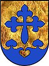
The municipal coat of arms for Kaindorf was awarded with effect from May 1, 1987. The blazon (description of the coat of arms) reads:
- "Above a blue linden leaf cut in the base of the shield in gold a blue cross of St. James ."
The reassignment of the same coat of arms took place with effect from September 1, 2015. The St. James cross refers to the church patron (St. Jacob), the linden leaves to the manorial rule (linden leaves in the coat of arms of Messrs. Neuberg ). The color blue refers to the location of the municipality on the Saifen .
Personalities
- Honorary citizen
- 1977: Friedrich Niederl (1920–2012), governor
- 1985: Josef Krainer (1930–2016), governor
- People related to the community
- Willibald Rodler (1931–2012), Episcopal Vicar for diocesan education in the Diocese of Graz-Seckau
- Karin Ammerer (* 1976), children's book author
Web links
- 62272 - Kaindorf. Community data, Statistics Austria .
- www.markt-kaindorf.at Website of the market town
- Entry on Kaindorf in the Austria Forum (in the AEIOU Austria Lexicon )
Individual evidence
- ↑ Local council election 2020 - results Kaindorf. orf.at , accessed on August 22, 2020 .
- ^ Announcement of the Styrian state government of November 21, 2013 about the unification of the market community Kaindorf and the communities Dienersdorf and Hofkirchen bei Hartberg, all political district Hartberg-Fürstenfeld. Styrian Provincial Law Gazette of December 6, 2013. No. 153, 35th issue. ZDB ID 705127-x . Pp. 682-683.
- ↑ Statistics Austria: Population on January 1st, 2020 by locality (area status on January 1st, 2020) , ( CSV )
- ↑ Federal Office for Metrology and Surveying, Regional Information, reference date December 31, 2016, accessed on February 19, 2017
- ↑ Wiener Zeitung : A total of 87 percent of the Eastern Styrian communities surveyed were against merger , November 20, 2011. ( Memento of November 24, 2011 in the Internet Archive )
- ↑ The new municipal structure of Styria ( Memento of the original from July 29, 2013 in the Internet Archive ) Info: The archive link was inserted automatically and has not yet been checked. Please check the original and archive link according to the instructions and then remove this notice. . List of final version A01, 2012 (pdf, gemeindeststrukturreform.steiermark.at; 97 kB).
- ^ Map in the presentation of the results of the municipal structural reform . kleinezeitung.at, January 21, 2013. Map status January 13, 2013
- ↑ Elections. Retrieved March 26, 2020 .
- ↑ Marktgemeinde Kaindorf: Gemeindezeitung, May 2015 edition, p. 3 ( page no longer available , search in web archives ) Info: The link was automatically marked as defective. Please check the link according to the instructions and then remove this notice. (PDF document, 2.63 MB; accessed on May 22, 2015)
- ↑ Regional Media Austria: Thomas Teubl elected mayor of Kaindorf. Retrieved August 23, 2016 .
- ↑ Communications from the Styrian State Archives 38, 1988, p. 31
- ↑ 61. Announcement of the Styrian state government of August 6, 2015 on the granting of the right to use a municipal coat of arms to the market town of Kaindorf (political district Hartberg-Fürstenfeld) , accessed on August 12, 2015


