
Ottendorf an der Rittschein
|
Ottendorf an der Rittschein
|
||
|---|---|---|
| coat of arms | Austria map | |
 |
|
|
| Basic data | ||
| Country: | Austria | |
| State : | Styria | |
| Political District : | Hartberg-Fürstenfeld | |
| License plate : | HF (from 1.7.2013; old: FF) | |
| Surface: | 14.27 km² | |
| Coordinates : | 47 ° 3 ' N , 15 ° 54' E | |
| Height : | 297 m above sea level A. | |
| Residents : | 1,555 (January 1, 2020) | |
| Postcodes : | 8312, 8262 | |
| Area code : | 03114 | |
| Community code : | 6 22 32 | |
| NUTS region | AT224 | |
| Address of the municipal administration: |
Ottendorf an der Rittschein 132 8312 Ottendorf an der Rittschein |
|
| Website: | ||
| politics | ||
| Mayor : | Josef Haberl ( ÖVP ) | |
|
Municipal Council : (2020) (15 members) |
||
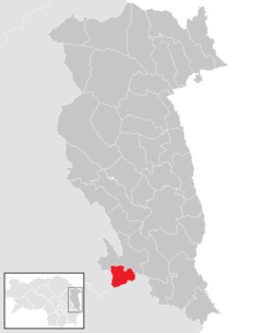
| Location of Ottendorf an der Rittschein in the Hartberg-Fürstenfeld district | ||
  |
||
 Parish church in Ottendorf |
||
| Source: Municipal data from Statistics Austria | ||


Ottendorf an der Rittschein is a municipality with 1555 inhabitants (as of January 1, 2020) in the judicial district of Fürstenfeld and the political district of Hartberg-Fürstenfeld in Styria .
geography
Ottendorf an der Rittschein is located in Styria.
Community structure
The community consists of four cadastral communities (area: as of December 31, 2018):
- Breitenbach (148.97 ha )
- Ottendorf (617.45 ha)
- Walkersdorf (360.51 ha)
- Ziegenberg (300.49 ha)
The municipality comprises four localities (population as of January 1, 2020):
- Breitenbach (91)
- Ottendorf an der Rittschein (875)
- Walkersdorf (351)
- Goat Mountain (238)
Incorporations
On January 1, 1969, the communities of Walkersdorf ( Feldbach district ) and Ottendorf bei Gleisdorf ( Weiz district ) were assigned to the Fürstenfeld district administration and merged to form the new community of Ottendorf an der Rittschein.
history
Ottendorf comes from "dorf des otto". The places in the municipality were founded by Bavarian settlers in the 10th century. Ottendorf is mentioned in writing for the first time in 1318 in the fief book of the Bishop of Seckau.
From 1850 Ziegenberg was an independent municipality in the judicial district of Fürstenfeld or Feldbach district, while Breitenbach belonged to the administrative municipality of Walkersdorf in the judicial district and Feldbach district from 1850. It was not until 1935 that Ottendorf was separated from Oed (today's municipality of Markt Hartmannsdorf ) and became its own municipality.
Population development

Culture and sights
politics
mayor
Mayor of the community is Josef Haberl from the ÖVP.
The community board also includes the deputy mayor Ewald Deimel (ÖVP) and the community treasurer Alois Flechl (ÖVP).
Municipal council
The municipal council consists of 15 members. According to the result of the 2015 municipal council election , it is composed as follows:
- 12 mandates ÖVP
- 2 mandates SPÖ
- 1 mandate FPÖ
- 1 mandate The Greens
| Political party | 2015 | 2010 | 2005 | 2000 | ||||||||
|---|---|---|---|---|---|---|---|---|---|---|---|---|
| be right | % | Mandates | St. | % | M. | St. | % | M. | St. | % | M. | |
| ÖVP | 732 | 72 | 12 | 726 | 70 | 12 | 595 | 59 | 9 | 554 | 61 | 10 |
| SPÖ | 97 | 10 | 1 | 172 | 17th | 2 | 240 | 24 | 4th | 171 | 19th | 3 |
| FPÖ | 84 | 8th | 1 | 56 | 5 | 0 | 39 | 4th | 0 | 90 | 10 | 1 |
| The Greens Ottendorf | 97 | 10 | 1 | 80 | 8th | 1 | 134 | 13 | 2 | 88 | 10 | 1 |
| Eligible voters | 1,320 | 1,269 | 1,216 | 1,097 | ||||||||
| voter turnout | 77% | 82% | 83% | 84% | ||||||||
coat of arms
The municipal coat of arms was awarded with effect from June 1, 1990.
Blazon (coat of arms description):
- "A shield made of red and gold, inside a crossed cross with a mix of colors, from each of whose arms a clover grows, in the first field to the right, in the second up, in the third down and in the fourth field to the left."
Personalities
Honorary citizen
- 2019: Josef Haberl, Mayor of Ottendorf an der Rittschein 2005–2019
Personalities associated with the community
- Heike Manhart (* 1993), soccer player
Individual evidence
- ↑ City council election 2020 - results Ottendorf an der Rittschein. orf.at , accessed on August 22, 2020 .
- ↑ CSV file from REGIONALINFORMATION.zip (1,221 kB) ; accessed on January 12, 2019
- ↑ Statistics Austria: Population on January 1st, 2020 by locality (area status on January 1st, 2020) , ( CSV )
- ↑ Municipality of Ottendorf an der Rittschein: Municipal Council , accessed on May 24, 2015.
- ↑ Communications from the Styrian State Archives 41, 1991, p. 34
- ↑ https://www.mein Bezirk.at/hartberg-fuerstenfeld/c-eople/josef-haberl-zum-ehrenbuerger-von-ottendorf-ernannt_a3540522 , accessed on September 13, 2019.
Web links
- 62232 - Ottendorf on the Rittschein. Community data, Statistics Austria .
.svg)
Bad Blumau | Bad Loipersdorf | Bad Waltersdorf | Book-St. Magdalena | Burgau | Dechantskirchen | Ebersdorf | Feistritztal | Friedberg | Fürstenfeld | Grafendorf near Hartberg | Greinbach | Großsteinbach | Großwilfersdorf | Hartberg | Hartberg surroundings | Hartl | Ilz | Kaindorf | Lafnitz | Neudau | Ottendorf an der Rittschein | Pinggau | Pöllau | Pöllauberg | Rohr bei Hartberg | Rohrbach an der Lafnitz | Sankt Jakob im Walde | Sankt Johann in der Haide | Sankt Lorenzen am Wechsel | Shepherds | Söchau | Stubenberg | Advance | Waldbach-Mönichwald | Wenigzell