
Sankt Johann in der Haide
|
Sankt Johann in der Haide
|
||
|---|---|---|
| coat of arms | Austria map | |
 |
|
|
| Basic data | ||
| Country: | Austria | |
| State : | Styria | |
| Political District : | Hartberg-Fürstenfeld | |
| License plate : | HF (from 1.7.2013; old: HB) | |
| Surface: | 23.56 km² | |
| Coordinates : | 47 ° 17 ' N , 16 ° 1' E | |
| Height : | 387 m above sea level A. | |
| Residents : | 2,194 (January 1, 2020) | |
| Postcodes : | 8295, 8230, 8294 | |
| Area code : | 03332 | |
| Community code : | 6 22 44 | |
| NUTS region | AT224 | |
| Address of the municipal administration: |
Sankt Johann in der Haide 100 8295 Sankt Johann in der Haide |
|
| Website: | ||
| politics | ||
| Mayor : | Günter Müller ( SPÖ ) | |
|
Municipal Council : (2020) (15 members) |
||
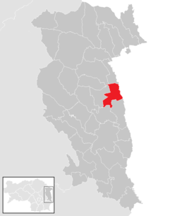
| Location of Sankt Johann in der Haide in the Hartberg-Fürstenfeld district | ||
  |
||
| Source: Municipal data from Statistics Austria | ||


Sankt Johann in der Haide with 2194 inhabitants (as of January 1, 2020) is a municipality in the judicial district of Fürstenfeld and in the political district of Hartberg-Fürstenfeld in Styria in Austria .
geography
Sankt Johann in der Haide is about four kilometers east of the district capital Hartberg am Lungitzbach . The community is located on the eastern edge of the Eastern Styrian hill country and extends in the east to the border with Burgenland , which is formed in this area by the Lafnitz .
While the Lungitzbach and Lafnitz flow through the municipality in its eastern half, the western part is drained by the tributaries of the Hartberger Safens . In terms of population distribution, the municipality is divided into two halves by the Lungitzbach: to the west of it are almost all settlements, while the area east of the Lungitzbach is predominantly forested (Ghartwald).
Community structure
|
structure
|
||||||
|
Legend for the breakdown table
|
The community consists of the three cadastral communities Schölbing (596.14 ha), St. Johann in der Haide (1,068.76 ha) and Unterlungitz (688.32 ha).
The municipality includes the following 7 localities (residents as of January 1, 2020):
- Altenberg (431)
- Klafferau (21)
- Mitterberg (58)
- Sankt Johann in der Haide (855)
- Schölbing (437) with Eden and Katzengreith
- Steinbüchl (8)
- Unterlungitz (384) with Maierhofermühle
Incorporations
The formerly independent communities Altenberg, Schölbing and Unterlungitz were incorporated on January 1, 1969.
Neighboring communities
| Grafendorf near Hartberg | Lafnitz | Allhau market |
| Hartberg |
.svg)
|
Allhau market |
| Book-St. Magdalena | Rohr near Hartberg | Wolfau |
climate
|
Average monthly temperatures and rainfall for Altenberg bei Hartberg
|
|||||||||||||||||||||||||||||||||||||||||||||||||||||||||||||||||||||||||||||||||||||||||||||||||||||||||||||||||||||||||||||||||||||||||||
history
Sankt Johann in der Haide was first mentioned in 1147 as Rudegersdorf . The name of the community at that time reminds us that Margrave Leopold the Strong gave his ministerial Rudiger an estate in the community area around 1128/29, the land of which included the later community area. Since the land was completely forested, it first had to be cleared before the planned village was established. The forest east of the settlement was left as a "border fortification" and has been preserved to this day as Ghartwald.
It was not until the 15th century that the village took over the current name of St. John . The addition "in der Haide" does not mean heather , but forest , as it is derived from the term "Hart" - in dialect "Hoad".
Even in Roman times , today's municipal area was a border area, as the border between the provinces of Noricum and Pannonia ran here. Until 1921, today's border between Styria and Burgenland was the state border between Austria and Hungary . This meant that the village was often the victim of armed conflicts. In the High Middle Ages it was visited by the Hungarians , later by the Turks , Haidukes and Kuruzen .

During the Second World War , fighting came to a standstill in May 1945 just before reaching the community. Due to the frequent devastation, there are hardly any historical buildings and treasures in Sankt Johann in der Haide. Only the buildings of the last two centuries have been preserved, but this was all the more elaborately cared for. Businesses have only been settling here since 1945.
In 1770 258 people lived in Sankt Johann, in 1846 there were 307. In 1849 Sankt Johann in der Haide became an independent municipality. In 1969 the community was enlarged to include Schölbing and Unterlungitz.
Scholbing
Schölbing is a planned village complex from the colonization period . It is first mentioned in a document in 1252 as Schelleborn . The name means "at the shepherds' huts", which suggests that the area was originally used as pastureland.
Unterlungitz
The planned settlement of Unterlungitz is first mentioned in 1330 as Nider Lunkawitz . In 1850 the community became independent. It was characterized by its well-developed club life.
Population development
The community's population is growing steadily due to the constant construction of new apartments as well as row and single-family houses. People living in the municipality of Sankt Johann in der Haide - as of December 31, 2012–2026. A population growth of 12.5% is predicted by 2030.

Culture and sights
- Parish church Sankt Johann in der Haide
- Catholic branch church Mariae Sacrifice in Schölbing
- The Johannisbründl is located in the center of Sankt Johann.
- In Sankt Johann in der Haide there is a military cemetery from the Second World War .
Economy and Infrastructure
Established businesses
Numerous large companies have settled in the industrial and commercial area of Sankt Johann in der Haide at the Hartberg motorway exit.
traffic

Sankt Johann in der Haide is very conveniently located. The south motorway A2 runs through the municipality from Vienna to Graz . It can be reached via the Hartberg junction (115) in the municipality. The junction "Lafnitztal" (111), which is also in the municipality, can only be reached from Burgenland. The Burgenland road B 50 from Hartberg to Oberwart leads directly through St. Johann.
The thermal railway runs directly through the municipality and can be reached via the “St. Johann in der Haide ”. There are two-hour connections from ÖBB to Vienna and via Hartberg to Graz.
The nearest larger airports such as Graz-Thalerhof and Vienna-Schwechat can be reached quickly and easily via the motorway or by train (Thalerhof in around 45 minutes and Schwechat in around 75 minutes).
education

There is a new elementary school in Sankt Johann in der Haide. The secondary schools are located in Hartberg. The Hartberg Music School also looks after the community of St. Johann in der Haide.
politics
The municipal council consists of 15 members. According to the result of the 2020 municipal council elections , it is composed as follows:
| Political party | 2020 | 2015 | 2010 | 2005 | 2000 | 1995 | 1990 | ||||||||||||||
|---|---|---|---|---|---|---|---|---|---|---|---|---|---|---|---|---|---|---|---|---|---|
| Sti. | % | M. | Sti. | % | M. | Sti. | % | M. | Sti. | % | M. | Sti. | % | M. | Sti. | % | M. | Sti. | % | M. | |
| SPÖ | 792 | 62.26 | 9 | 824 | 62 | 10 | 763 | 59 | 9 | 814 | 62 | 10 | 694 | 59 | 10 | 423 | 36 | 6th | 340 | 30th | 5 |
| ÖVP | 480 | 37.74 | 6th | 361 | 27 | 4th | 533 | 41 | 6th | 472 | 36 | 5 | 331 | 28 | 4th | 427 | 37 | 6th | 504 | 44 | 7th |
| FPÖ | not running | 152 | 11 | 1 | not running | 36 | 3 | 0 | 51 | 4th | 0 | 124 | 11 | 1 | 40 | 4th | 0 | ||||
| Economic list | not running | not running | not running | not running | 100 | 9 | 1 | 139 | 12 | 2 | not running | ||||||||||
| Citizens' Initiative | not running | not running | not running | not running | not running | 46 | 4th | 0 | 128 | 11 | 2 | ||||||||||
| Altenberg-Schölbinger home list | not running | not running | not running | not running | not running | not running | 89 | 8th | 1 | ||||||||||||
| List of names of the couple Josef | not running | not running | not running | not running | not running | not running | 34 | 3 | 0 | ||||||||||||
| Eligible voters | 1,876 | 1,763 | 1,626 | 1,537 | 1,352 | ||||||||||||||||
| voter turnout | 68.92% | 77% | 82% | 87% | 89% | 92% | 96% | ||||||||||||||
- mayor
- since ? Günter Müller (SPÖ)
coat of arms
On February 19, 1989, the municipality of Sankt Johann in der Haide was awarded the municipal coat of arms by the Styrian state government.
Blazon : "In blue over two golden trees of life, which are side by side an upright golden ploughshare, golden a nimbated lamb standing against it, holding an oblique cross-stick with its right forefoot."
Sons and daughters of the church
- Werner Kogler (born November 20, 1961 in Hartberg, Styria) is an Austrian politician (Die Grünen) and economist.
Web links
- 62244 - Sankt Johann in der Haide. Community data, Statistics Austria .
Individual evidence
- ↑ Municipal council election 2020 - results Sankt Jakob in der Haide. orf.at , accessed on August 22, 2020 .
- ↑ Statistics Austria: Population on January 1st, 2020 by locality (area status on January 1st, 2020) , ( CSV )
- ↑ Municipal council election in St. Johann iD Haide 2020. In: orf.at
- ^ Parish of St. Johann in der Haide: parish council (accessed on May 26, 2015)
.svg)
Bad Blumau | Bad Loipersdorf | Bad Waltersdorf | Book-St. Magdalena | Burgau | Dechantskirchen | Ebersdorf | Feistritztal | Friedberg | Fürstenfeld | Grafendorf near Hartberg | Greinbach | Großsteinbach | Großwilfersdorf | Hartberg | Hartberg surroundings | Hartl | Ilz | Kaindorf | Lafnitz | Neudau | Ottendorf an der Rittschein | Pinggau | Pöllau | Pöllauberg | Rohr bei Hartberg | Rohrbach an der Lafnitz | Sankt Jakob im Walde | Sankt Johann in der Haide | Sankt Lorenzen am Wechsel | Shepherds | Söchau | Stubenberg | Advance | Waldbach-Mönichwald | Wenigzell