
Fischbach Alps
| Fischbach Alps | ||
|---|---|---|
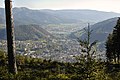
 View of the Fischbach Alps. |
||
| Highest peak | Stuhleck ( 1782 m above sea level ) | |
| location | Styria , Austria | |
| part of | Edge mountains east of the Mur | |
| Classification according to | Trimmel 2840; Landscape structure of Styria R.7 | |
|
||
| Coordinates | 47 ° 34 ' N , 15 ° 47' E | |

The Fischbacher Alps are part of the peripheral mountain range east of the Mur .
Location and landscape
They are a gentle, elongated, wooded and alpine mountain range with a low mountain range character in Styria , Austria , south of the Mürz . They are the eastern foothills of the Central Alps and part of the Styrian Rim Mountains .
They extend from the breakthrough of the Mur in the west to Feistritzsattel in the east. The highest peak is the Stuhleck ( 1782 m above sea level ). Other elevations are the Pretul ( 1656 m ) and Amundsenhöhe ( 1666 m ), the Teufelstein ( 1498 m ), the Stanglalpe ( 1490 m ), the Sauernkogel ( 1451 m ), the Steinriegel ( 1577 m ), the Hochschlag ( 1580 m ) and the Rennfeld ( 1629 m ).
Culture
They are named after the town of Fischbach .
In the Fischbacher Alps lies Alpl (municipality of Krieglach ), the birthplace of Peter Rosegger . In 1998, a broadcast of the ORF series Klingendes Österreich was dedicated to the Fischbach Alps. Under the title Mountains without hardness: The Fischbach Alps , the program took you to the most important villages and mountain peaks in the Fischbach Alps.

The refuge on the Pretul, named after Peter Rosegger
at Mürzzuschlag

The Fischbach Alps (center) around 1876 (recording sheet of the state survey )
.JPG)


