Rennfeld
| Rennfeld | ||
|---|---|---|
|
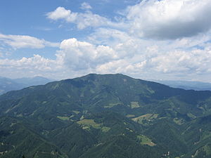
The racing field seen from the Hochlantsch ( 1720 m ) to the south |
||
| height | 1629 m above sea level A. | |
| location | Styria , Austria | |
| Mountains | Fischbacher Alps , foothills east of the Mur | |
| Dominance | 6.7 km → Hochlantsch | |
| Notch height | 628 m ↓ Eibeggsattel | |
| Coordinates | 47 ° 24 '25 " N , 15 ° 21' 22" E | |
|
|
||
| rock | Paragneiss , plagioclase amphibolite | |
| Normal way | Hike from Bruck an der Mur , Frauenberg or Pernegg | |
The Rennfeld is the 1,629 m high westernmost peak of the Fischbacher Alps in the Austrian Upper Styria, in the gusset between the rivers Mur and Mürz . At the highest point of the Rennfeld, the municipal boundaries of Bruck an der Mur , Pernegg an der Mur and Sankt Marein im Mürz Valley meet ; the summit marks the highest point of each of the three municipalities.
The Rennfeld can be climbed from Bruck an der Mur in the west via the Kaltbachgraben and the Glanzgraben, from Kapfenberg in the north via Frauenberg, from Pernegg in the southwest via the Gabraun-Graben or from Breitenau am Hochlantsch in the southeast (each around 1000-1200 meters in altitude) . A variant of the Central Alpine Trail leads over the summit.
On the eastern flank of the Rennfeld is the Buchecksattel, which offers an easier transition from Frauenberg to Breitenau. The mountain is regarded as a decidedly panoramic mountain and is one of the three local mountains of Bruck an der Mur . (Rennfeld, Hochanger, Madereck).
The Rennfeld forms a wide plateau in a west-east orientation. There you will find the Ottokar-Kernstock-Schutzhaus ( 1620 m ) and a radio relay station a few meters below the summit .


