
Ringkogel
| Ringkogel | ||
|---|---|---|
 Ringkogel via Hartberg (from the east) |
||
| height | 789 m above sea level A. | |
| location | Styria , Austria | |
| Mountains | Edge mountains east of the Mur | |
| Dominance | 2.2 km → Wullmenstein | |
| Notch height | 100 m ↓ venue | |
| Coordinates | 47 ° 17 '51 " N , 15 ° 57' 5" E | |
|
||
| rock | Crystalline | |
| Age of the rock | Carbon | |
| particularities | Ringwarte observation tower | |
 Ringkogel from the south, to the left the higher Wullmenstein ( 867 m ) |
||

The Ringkogel is a hill in the Eastern Styrian hill country . It has a height of 789 m above sea level. A. and is part of the Masenberg massif . It is considered the local mountain of the district capital Hartberg, which lies at its foot .
Several hiking trails lead up the mountain, the shortest of them from the parking lot to the west at the venue . The castle Neuberg and the Villa Rustica in Löffelbach are located on the south-facing slopes .
history
The Ringkogel area was already settled in prehistoric times, as evidenced by the remains of a Hallstatt and Latène settlement on the summit. The Celtic ring wall gave the mountain its name. Thanks to its exposed location with an unobstructed view of the whole of Eastern Styria, the Ringkogel was of military importance until the Kuruzen invasions at the beginning of the 18th century and was used as a signal mountain for chalk fires .
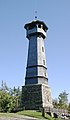
Ring control room
Today there is a nationally known observation tower on the summit , the Ringwarte . It offers its visitors a panoramic view of the Eastern Styrian hill country. It was built in 1906 under the Mayor of Hartberg, Raimund Obendrauf. The 30 m high wooden observation tower is built on the granite ground floor. The ring control room was renovated in 2007/08.
Tumulli
At the Penzendorfer Höhe 530 m above sea level. A. there are some barrows that indicate an earlier Roman settlement.
Creator Banker
A table and two wooden benches on the edge of a forest meadow, that's the Schöpferbankerl resting place, named after the lawyer and artist Friedrich Schöpfer .
Allmerfelsen
The Allmerfelsen is a large, approx. 30 meter high rock that is also used for climbing. It is located in the forest around 200 meters south of Neubergstrasse near the Brühl.
Wine region
Due to the mild climatic conditions, the northernmost wine-growing region in Styria is located on the southern slopes of the Ringkogel.
photos

Ringkogel near Hartberg
Ring control room at Hartberg


Web links
Individual evidence
- ^ Ring control room at bergfex.at