Dreiländerecke (near Sankt Martin an der Raab)
| Border triangle / Tromejnik / [A felsőszölnöki] Hármashatár | ||
|---|---|---|
|
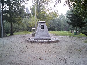
The memorial stone at the border triangle |
||
| height | 387 m above sea level A. | |
| location | near Oberdrosen / Dolič / Felsőszölnök , Austria / Slovenia / Hungary | |
| Mountains | East Styrian Riedelland / Goričko / Vasi Hegyhát , Alpine foothills in the southeast | |
| Coordinates | 46 ° 52 '9 " N , 16 ° 6' 50" E | |
|
|
||
| Development | Access road, long-distance hiking trail 07 , Burgenland long-distance hiking trail | |
| particularities | Dreiländer-Grenzberg ; westernmost point of Hungary; Documentation center | |
The three-country corner , Slovenian Tromejnik , Hungarian [ A Felsőszölnöki ] Hármashatár ("Dreiländereck bei Felsőszölnök " / Oberzemming) is 387 m above sea level. A. / i. J. high mountain, which forms the border point Austria - Slovenia - Hungary .
Location and landscape
The mountain lies on the border South Burgenland - Prekmurje (Slovenian Übermurgebiet) - Őrség (dt. Wart, politically Jennersdorf district - Pomurska statistical region - Zala county ), in the hilly landscape, the Neuhauser Hügelland , slow. Goričko ("hill country"), Hungarian Vasi-Hegyhát ("Vas mountains") is called. The summit rises a good 8 kilometers south of Jennersdorf , 15 kilometers southwest of Szentgotthárd and almost 25 kilometers north of Murska Sobota , and forms the municipal boundary of Sankt Martin an der Raab , Kuzma and Felsőszölnök .
The ridge of the mountains stretches here in a south-west-north-east direction, starting at the border triangle also in a west-east direction, and forms the watershed of the Mur ( Mura , and also Drava ) to the Raab ( Rába ) : here, the Drosenbach and flow north northeast of the Szölnöki-patak (Zemingbach) each to the Raab, and to the south a nameless channel to the Lukaj , which goes to the Mur via Ledavsko jezero - Ledava . Directly north of the summit is the Holzmannkogel ( 393 m above sea level ), with the Austro-Hungarian border shortening over the Zeminggraben, which is part of Austria. To the southwest lies Kölbereck ( 360 m above sea level ) on the Austrian-Slovenian border . To the southeast is the Slamarin breg ( 389 m. I. J. ), the Slovenian-Hungarian border runs here a little north of the ridge.
The mountain is the westernmost point of Hungary. For Slovenia it is not the northernmost point, that is the Katin breg ( 353 m. In the year ) 10 km east.
History and Development


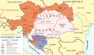
Originally the mountain was still completely in the Kingdom of Hungary , since the Middle Ages the Kutschenitza / Kučnica / Kucsenyica and the Riedel between Kapfenstein and Neuhaus formed the border between the Duchy of Steyer (Styria) and Hungary. With the collapse of the Habsburg Monarchy and the Treaty of St. Germain in 1919, today's Prekmurje came to the SHS state (later Yugoslavia). The tri-border area near Sichauf and Ocinje , today's border point Burgenland-Styria-Slovenia, reminds of this .
With the Treaty of Trianon in 1920, German West Hungary came to Austria and forms today's Burgenland. As a result, the border point of the three states shifted 10 kilometers north-east here to the Tromejnikberg.
As early as 1922, a triangular-pyramid-shaped memorial stone was erected on the wooded hilltop, which reminds of the two key dates September 10, 1919 (St. Germain) and June 4, 1920 (Trianon), and - despite all border conflicts - the will of the three at the time Habsburg successor states to a friendly reorganization of Europe. In Slovenia it is registered as a cultural monument.
In the course of the Second World War and the subsequent Cold War , however, the mountain fell into the Iron Curtain with Hungary, and the border between neutral Austria and Yugoslavia, which was actually non-aligned, could not be freely crossed. Only after the fall of the Iron Curtain in 1989 and the respective accession to the EU did the site develop into a common memorial to international understanding.
A plaque commemorates a meeting of the mayors of Fürstenfeld, Körmend and Murska Sobota , Erich Kospach, Jenő Kercsmar and Andrej Gerenčer, when the border fence through Hungary was dismantled on May 27, 1989 (the border was then symbolized on June 27 by Foreign Minister Alois Mock and Gyula Horn near Sopron , and officially opened on August 19, 1989 ), later a square memorial stone was erected. On the Slovenian side, after Slovenia's independence in 1993, the Slovenian coat of arms was attached to the border stone. When Austria joined the EU , the point became the EU external border . At an international meeting in 1998, Slovenia planted a linden tree. When Slovenia and Hungary joined the EU on May 1, 2004, another memorial stone was donated by the municipalities of St. Martin an der Raab, Kuzma and Felsőszölnök , and the summit area has since been freely accessible through the Schengen area .
Later, as part of the cross-border Raab-Őrség-Goričko Nature Park , display boards, rest benches and a pavilion were set up, so that a documentation center that is interesting in terms of both political history and natural landscape has emerged. The mountain is also repeatedly used as a venue for ceremonies.
From the Austrian side a road led up the mountain, with a parking lot below. In addition, the Ostösterreichischer Grenzlandweg (Austrian long-distance hiking trail 07) and the Burgenland long-distance hiking trail lead over the summit.
See also
Web links
- Tromejnik on kraji.eu (private photo website, with panorama and detailed views)
Individual evidence
- ↑ in the official Slovenian map on a larger scale, 390 m. i. J. , the special card 1: 10,000, however, gives 387.6 m. i. J .; there is no official information for the Hungarian monitoring network .
- ^ A b Gerhard Karl Lieb: The tri-border region Austria-Slovenia-Hungary. An excursion to cross-border perspectives. In: GeoGraz 44 - 2009, section Das Dreiländereck (6) , p. 5 ( Article pdf ( Memento of the original from September 16, 2016 in the Internet Archive ) Info: The archive link was inserted automatically and has not yet been checked. Please check the original and Archive link according to instructions and then remove this note. , On gw.didaktik-graz.at) - with lots of background information on the border area.
- ↑ Other sources mention 1924, such as Ul. RS, št. 16/2008; park-goricko.org ; kmetija.hu .
- ↑ Opis enote nepremične cultures dediščine, evidenčna številka 21119 . Register cultures dediščine, Ministrstvo za kulturo Republike Slovenije (Zakon o varstvu cultures dediščine, Uradni list RS, št. 16/2008)
- ↑ a b Cultural site: Dreiländereck. Krajinski park Goričko (park-goricko.org).


