Szentgotthárd district
| circle Szentgotthárdi járás
Szentgotthárd |
|
|---|---|
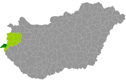
 Location of the district in Hungary |
|
| Basic data | |
| Country | Hungary |
| County | Vas |
| Seat | Szentgotthárd |
| surface | 255 km² |
| Residents | 15,080 (January 1, 2016) |
| density | 59 inhabitants per km² |
The district of Szentgotthárd ( Hungarian Szentgotthárdi járás ) is the westernmost district in Hungary. It is located in the west of the western Hungarian county of Vas and borders in the east and south-east on the district of Körmend , which separates it from the rest of the county. In the north and northwest, seven municipalities form the state border with Austria ( Burgenland ) and in the south three municipalities form the state border with Slovenia . Felsőszölnök municipality has two foreign neighbors.
history
In the course of the Hungarian administrative reform, the district emerged in early 2013 as the successor to the small area of the same name (Hungarian Szentgotthárdi kistérség ), reinforced by a municipality from the small area Őriszentpéter .
Community overview
The Szentgotthárd District has an average municipality size of 943 inhabitants on an area of 15.94 square kilometers. The population density of the smallest district in the county is below the value of the entire county. The district seat is in the only town, Szentgotthárd , near the Austrian border.
| 16 municipalities | status | Origin small area |
population | Area (km²) | Population density (inh / km²) |
||
|---|---|---|---|---|---|---|---|
| October 01, 2011 | 01/01/2013 | 01/01/2016 | |||||
| Alsószölnök * | local community | Szentgotthárd | 369 | 373 | 359 | 10.02 | 35.8 |
| Apátistvánfalva | local community | Szentgotthárd | 364 | 370 | 386 | 12.86 | 30.0 |
| Csörötnek | local community | Szentgotthárd | 914 | 902 | 885 | 20.53 | 43.1 |
| Felsőszölnök * / ** | local community | Szentgotthárd | 572 | 584 | 579 | 23.56 | 24.6 |
| Gasztony * | local community | Szentgotthárd | 430 | 445 | 414 | 14.27 | 29.0 |
| Kétvölgy ** | local community | Szentgotthárd | 105 | 97 | 98 | 6.28 | 15.6 |
| Kondorfa | local community | Őriszentpéter | 515 | 514 | 482 | 21.61 | 22.3 |
| Magyarlak | local community | Szentgotthárd | 782 | 790 | 752 | 7.62 | 98.7 |
| Nemesmedves * | local community | Szentgotthárd | 17th | 27 | 27 | 4.74 | 5.7 |
| Orfalu ** | local community | Szentgotthárd | 61 | 65 | 69 | 6.94 | 9.9 |
| Rábagyarmat | local community | Szentgotthárd | 805 | 806 | 782 | 16.79 | 46.6 |
| Rátót | local community | Szentgotthárd | 242 | 306 | 270 | 7.27 | 37.1 |
| Rönok * | local community | Szentgotthárd | 414 | 417 | 407 | 17.22 | 23.6 |
| Szakonyfalu * | local community | Szentgotthárd | 356 | 360 | 357 | 11.19 | 31.9 |
| Szentgotthárd * | city | Szentgotthárd | 8,678 | 8,787 | 8,872 | 67.73 | 131.0 |
| Vasszentmihály | local community | Szentgotthárd | 337 | 337 | 341 | 6.41 | 53.2 |
| Szentgotthárd district | 14,961 | 15,180 | 15,080 | 255.04 | 59.1 | ||
* Border municipality to Austria
** border municipality to Slovenia
swell
PDF and XLS files: 2011
Census :
2013:; 2016:
Individual evidence
- ↑ KSH: 2011. Évi Népszámlálás. In: 3. Területi adatok. KSH, accessed on December 31, 2016 (Hungarian, also via: http://www.terezvaros.hu/testuleti/nepsz2011-3/pdf/nepsz2011_03_18.pdf ).
- ↑ KSH: Regional data - Vas county. KSH, accessed on December 31, 2016 (English, 4th Data on Localities).
- ↑ KSH: Gazetteer of Hungary, 1st January, 2013. KSH, accessed April 7, 2017 (Hungarian / English).
- ↑ KSH: Gazetteer of Hungary, 1st January, 2016. KSH, accessed April 7, 2017 (Hungarian / English).