
Orfalu
| Orfalu | |||||
|
|||||
| Basic data | |||||
|---|---|---|---|---|---|
| State : | Hungary | ||||
| Region : | Western Transdanubia | ||||
| County : | Vas | ||||
| Small area until December 31, 2012 : | Szentgotthárd | ||||
| District since 1.1.2013 : | Szentgotthárd | ||||
| Coordinates : | 46 ° 53 ' N , 16 ° 16' E | ||||
| Area : | 6.94 km² | ||||
| Residents : | 64 (Jan. 1, 2011) | ||||
| Population density : | 9 inhabitants per km² | ||||
| Telephone code : | (+36) 94 | ||||
| Postal code : | 9982 | ||||
| KSH kódja: | 17093 | ||||
| Structure and administration (status: 2018) | |||||
| Community type : | local community | ||||
| Mayoress : | Ilona Goda (independent) | ||||
| Postal address : | Fő utca 51 9982 Orfalu |
||||
| Website : | |||||
| (Source: A Magyar Köztársaság helységnévkönyve 2011. január 1st at Központi statisztikai hivatal ) | |||||


Orfalu ( Andovci in Slovenian ) is a Hungarian municipality in the Szentgotthárd district in Vas County .
Geographical location
Orfalu is located eight kilometers south of the town of Szentgotthárd , one kilometer north of the border with Slovenia , on the small river Huszászi-patak . Neighboring communities are Apátistvánfalva and Farkasfa, a district of Szentgotthárd. On the other side of the border is the Slovenian town of Budinci .
Sons and daughters of the church
- Károly Doncsecz (1918–2002), master potter
Attractions
- Bell Tower ( Harangláb )
traffic
Country road No. 7456 runs through Orfalu, from which side road No. 74181 branches off in a southerly direction to the Slovenian border. The nearest train station is in Szentgotthárd.
photos
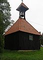
Bell tower

View of Orfalu
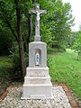
cross


literature
- Orfalu - Településképi Arculati Kézikönyv 2017. Edited by the municipal administration.
Web links
- Official website ( Hungarian )
- Orfalu község címere (Hungarian)