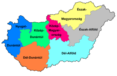
Regions of Hungary
In 1999, seven regions were created in Hungary , also to meet the requirements of the European Union (they correspond to NUTS 2 level in European statistics ). These regions are made up of the counties of Hungary and serve primarily statistical purposes.
Statistical regions
| Name of the region | Area (km²) |
Residents | Population density (per sq km) |
Counties | Cities with county law |
|---|---|---|---|---|---|
|
Northern Hungary Észak-Magyarország |
13,428 | 1,209,142 | 90 | Borsod-Abaúj-Zemplén , Heves , Nógrád | Miskolc , Eger , Salgótarján |
|
Northern Great Plain of Észak-Alföld |
17,749 | 1,492,502 | 84 | Hajdú-Bihar , Jász-Nagykun-Szolnok , Szabolcs-Szatmár-Bereg | Debrecen , Szolnok , Nyíregyháza |
|
Southern Great Plain of Dél-Alföld |
18,339 | 1,318,214 | 71 | Bács-Kiskun , Békés , Csongrád-Csanád | Kecskemét , Békéscsaba , Szeged , Hódmezővásárhely |
|
Central Hungary Közép-Magyarország |
6,919 | 2,951,436 | 426 | Pest , Budapest- capital | Érd |
|
Central Transdanubia Közép-Dunántúl |
11,237 | 1,098,654 | 97 | Komárom-Esztergom , Fejér , Veszprém | Tatabánya , Székesfehérvár , Dunaújváros , Veszprém |
|
Western Transdanubia Nyugat-Dunántúl |
11.209 | 996.390 | 88 | Győr-Moson-Sopron , Vas , Zala | Győr , Sopron , Szombathely , Zalaegerszeg , Nagykanizsa |
|
Southern Transdanubia Dél-Dunántúl |
14,169 | 947.986 | 66 | Baranya , Somogy , Tolna | Pécs , Kaposvár , Szekszárd |
Euroregions
The following Euroregions are at least partially within Hungary:
- Carpathian Euroregion : Győr-Moson-Sopron, Vas, Zala
- Danube-Drava-Sava Euroregion : Baranya, Somogy
- Euroregion Danube-Kreisch-Marosch-Tisza (DKMT): Bács-Kiskun, Békés, Csongrád, Jász-Nagykun-Szolnok
- Euroregion Ister-Granum : Komárom-Esztergom, Nógrád
The boundaries of the counties do not always coincide with those of the Euroregions, which means that they can overlap.
