
Fejér county
  |
|
.svg)
|
|
| Fejér | |
| County seat : | Székesfehérvár |
| Surface: | 4,358 km² |
| Residents: | 418,487 as of 2016 |
Fejér [ ˈfɛjeːr ] ( German Stuhlweiß ) is a county (administrative district) in north-central Hungary , west of the Danube . It borders the Pest , Bács-Kiskun , Tolna , Somogy , Veszprém and Komárom-Esztergom counties . The area is 4,358.45 km², and the population is 418,487 (2016).
The area is flat and forms part of the Great Hungarian Plain . The county seat is the old coronation town Székesfehérvár (Stuhlweissenburg) of the Kingdom of Hungary . Another important city is Dunaújváros .
structure
With the government ordinance No. 218/2012 of August 13, 2012, the statistical small regions (Hungarian kistérség ) were abolished on January 1, 2013 and replaced by an approximately equal number of districts (Hungarian járás ). The small areas were retained for a short time for planning and statistical purposes, but were finally abolished on February 25, 2014. There were ten small areas in the county before it was dissolved. The reform changed the boundaries of all administrative units.
Former classification
The following small areas ( kistérség ) existed in Fejér County until the end of 2012 :
| code | Small area | Administrative headquarters | Population (December 31, 2012) |
Area in km² |
Number of parishes |
including cities |
|---|---|---|---|---|---|---|
| 3701 | Bicske | Bicske | 37,888 | 618.73 | 16 | 1 |
| 3702 | Dunaújváros | Dunaújváros | 69,853 | 371.73 | 9 | 2 |
| 3703 | Enying | Enying | 20,844 | 433.11 | 9 | 1 |
| 3704 | Gárdony | Gárdony | 27,633 | 265.15 | 9 | 2 |
| 3705 | Mór | Mór | 34,496 | 417.55 | 13 | 2 |
| 3706 | Sárbogárd | Sárbogárd | 24,626 | 561.27 | 10 | 1 |
| 3707 | Székesfehérvár | Székesfehérvár | 134,517 | 667.14 | 18th | 2 |
| 3708 | Aba | Aba | 23,011 | 467.16 | 9 | - |
| 3709 | Adony | Adony | 24,143 | 319.96 | 8th | 2 |
| 3710 | Ercsi | Ercsi | 24,075 | 236.65 | 7th | 2 |
Current classification
Fejér county is divided into 9 districts (Hungarian járás ) with 108 villages. Of these, the cities of Dunaújváros and Székesfehérvár are with county law (Hungarian Megyei jogú város ), 15 cities without county law (Hungarian város ), 12 large municipalities (Hungarian nagyközség ) and 79 municipalities (Hungarian község ).

| Location type | number | Area (in km²) | Population on January 1, 2016 | Population density (Ew / km²) |
||||
|---|---|---|---|---|---|---|---|---|
| absolutely | proportionally | on average | absolutely | proportionally | on average | |||
| City with county law | 2 | 223.56 | 5.13% | 111.78 | 143,561 | 34.30% | 71,781 | 642.2 |
| Cities without county law | 15th | 1,112.54 | 25.53% | 74.17 | 111.117 | 26.55% | 7,408 | 99.9 |
| Large municipalities | 12 | 675.02 | 15.49% | 56.25 | 39,609 | 9.46% | 3,301 | 58.7 |
| Communities | 79 | 2,347.33 | 53.86% | 29.71 | 124,200 | 29.68% | 1,572 | 52.9 |
| Fejér county as a whole | 108 | 4,358.45 | 40.36 | 418,487 | 3,875 | 96.0 | ||
The current circles are:
| code | circle | Circular seat | Residents (January 1, 2013) |
Area in km² |
Number of parishes |
including cities |
|---|---|---|---|---|---|---|
| 077 | Bicske | Bicske | 34,597 | 520.10 | 14th | 1 |
| 078 | Dunaújváros | Dunaújváros | 91,854 | 650.05 | 16 | 4th |
| 079 | Enying | Enying | 13,187 | 278.46 | 5 | 1 |
| 080 | Gárdony | Gárdony | 29,775 | 306.79 | 10 | 2 |
| 081 | Martonvásár | Martonvásár | 26,531 | 277.13 | 8th | 2 |
| 082 | Mór | Mór | 32,957 | 395.13 | 12 | 2 |
| 083 | Polgardi | Polgardi | 19,938 | 294.94 | 9 | 1 |
| 084 | Sárbogárd | Sárbogárd | 28,509 | 653.52 | 12 | 1 |
| 085 | Székesfehérvár | Székesfehérvár | 143,738 | 982.33 | 22nd | 1 |
Biggest cities


| city | German name | Residents (January 1, 2016) |
|---|---|---|
| Székesfehérvár | Stuhlweissenburg | 98.207 |
| Dunaújváros | Neustadt an der Donau | 45.354 |
| Mór | moor | 14,010 |
| Gárdony | Gardon | 12,600 |
| Sárbogárd | Bochart | 12,038 |
| Bicske | Witschke | 11,984 |
| Ercsi | Ertsching | 7,981 |
| Polgardi | 6,856 | |
| Enying | 6,651 | |
| Pusztaszabolcs | 5,847 | |
| Martonvásár | Martinsmarkt | 5,592 |
| Csákvár | Chakwar | 5,253 |
| Rácalmás | 4,561 | |
| Aba | 4,424 |

Gorsium-Tác, aerial view

Lovasberény Palace

Nádasdladány Palace
Aerial view: Dég Palace


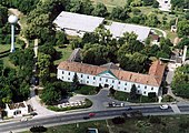
Aerial view: Bicske

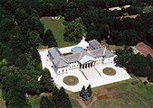
Aerial view: Seregélyes Palace
Enying Castle

Mór Castle


Population development
Population development of the county
Noteworthy is a steady decrease in the population between 2006 and 2014. Dates in bold are census results.
| date | population | date | population | |
|---|---|---|---|---|
| 01/01/1960 1 | 357.897 | 01/01/2007 | 428.711 | |
| 01/01/1970 | 391.272 | 01/01/2008 | 428,572 | |
| 01/01/1980 | 420.317 | 01/01/2009 | 428.295 | |
| 01/01/1990 | 418,852 | 01/01/2010 | 427.416 | |
| 01/01/2001 | 428.115 | 01/01/2011 | 426.120 | |
| 02/01/2001 | 434,317 | October 01, 2011 | 425,847 | |
| 01/01/2002 | 428.922 | 01/01/2012 | 421.927 | |
| 01/01/2003 | 428,409 | 01/01/2013 | 421.086 | |
| 01/01/2004 | 428,579 | 01/01/2014 | 419.506 | |
| 01/01/2005 | 428,798 | 01/01/2015 | 417,651 | |
| 01/01/2006 | 428,332 | 01/01/2016 | 418,487 |
1 1960: present population; otherwise resident population
Population development of the districts
Only the districts of Bickse and Gardony can show a positive population balance.
The Polgárd district was dissolved on December 31, 2014 after two years, the communities were divided between the neighboring Enying and Székesfehérvár districts.
| District name | Population level on January 1st | |||
|---|---|---|---|---|
| 2013 | 2014 | 2015 | 2016 | |
| Bicske | 34,597 | 34,777 | 35,555 | 35,773 |
| Dunaújváros | 91,854 | 91.097 | 90,583 | 89,818 |
| Enying | 13,187 | 13,082 | 20,487 | 20,253 |
| Gárdony | 29,775 | 29,978 | 30,273 | 32,830 |
| Martonvásár | 26,531 | 26,405 | 26,258 | 26,311 |
| Mór | 32,957 | 32,776 | 34.002 | 33,861 |
| Polgárd | 19,938 | 19,748 | dissolved | |
| Sárbogárd | 28,509 | 28,223 | 27,943 | 27,578 |
| Székesfehérvár | 143,738 | 143,420 | 152,550 | 152.063 |
| Fejér county | 421.086 | 419.506 | 417,651 | 418,487 |
History and culture
Museums
The Fejér County Museum of State Directorate is responsible for 10 county museums . The seat of the county is the town of Székesfehérvár (Stuhlweissenburg).
|
|
|
* County Museum
Partnerships
A partnership with the district of Göttingen in Lower Saxony has existed since 2000 .
Web links
- Fejér County Self-Government (Hungarian)
Individual evidence
- ^ Detailed Gazetteer of Hungary
- ↑ Gazetteer of Hungary, 1st January, 2013 (Hungarian / English)
- ↑ a b 6.1.1. Resident population by sex, January 1st (2001-) (STADAT table). KSH, accessed February 9, 2017 .
- ↑ Fejér County Museum Management FMMI (Fejér Megyei Múzeumok Igazgatósága)
- ↑ Entry about the partnerships on the homepage of the district of Göttingen.Retrieved on April 20, 2019, 12:37 am
Bács-Kiskun | Baranya | Békés | Borsod-Abaúj-Zemplén | Budapest | Csongrád-Csanád | Fejér | Győr-Moson-Sopron | Hajdú-Bihar | Heves | Jász-Nagykun-Szolnok | Komárom-Esztergom | Nógrád | Plague | Somogy | Szabolcs-Szatmár-Bereg | Tolna | Vas | Veszprém | Zala
Bicske | Dunaújváros | Enying | Gárdony | Martonvásár | Mór | Polgárdi ( dissolved) | Sárbogárd | Székesfehérvár
Aba | Adony | Bicske | Dunaújváros | Enying | Ercsi | Gárdony | Mór | Sárbogárd | Székesfehérvár
Coordinates: 47 ° 10 ' N , 18 ° 35' E