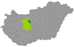
Martonvásár district
| circle Martonvásári járás
Martonvásár |
|
|---|---|
 Location of the district in Hungary |
|
| Basic data | |
| Country | Hungary |
| County | Fejér |
| Seat | Martonvásár |
| surface | 277.1 km² |
| Residents | 26,311 (January 1, 2016) |
| density | 95 inhabitants per km² |
The Martonvásár District ( Martonvásári járás in Hungarian ) is a district in the east of the central Hungarian Fejér County . It borders on Pest County to the east and internally on Bicske , Gárdony and Dunaújváros counties .
history
The district was created in the course of the Hungarian administrative reform at the beginning of 2013 as the successor to the small area Ercsi (Hungarian Ercsi kistérség ) with all 7 municipalities, supplemented by a municipality from the small area Bicske .
Community overview
The Martonvásár District has an average community size of 3,289 inhabitants on an area of 34.64 square kilometers. The population density of the smallest district is slightly below that of the entire county. The administrative seat is the city of Martonvásár , in the east of the district.
| local community | status | Origin small area |
population | surface | Population density (inh / km²) |
||
|---|---|---|---|---|---|---|---|
| October 01, 2011 | 01/01/2013 | 01/01/2016 | |||||
| Baracska | local community | Ercsi | 3,797 | 2,694 | 2,679 | 39.68 | 67.5 |
| Ercsi | city | Ercsi | 8,289 | 8,139 | 7,981 | 65.31 | 122.2 |
| Gyúró | local community | Ercsi | 1,261 | 1,223 | 1,272 | 24.37 | 52.2 |
| Kajászó | local community | Ercsi | 1,058 | 1,042 | 1,058 | 23.98 | 44.1 |
| Martonvásár | city | Ercsi | 5,732 | 5,603 | 5,592 | 31.25 | 178.9 |
| Ráckeresztúr | local community | Ercsi | 3,360 | 3,310 | 3,248 | 35.30 | 92.0 |
| Tordas | local community | Ercsi | 2,084 | 2,064 | 2,083 | 16.76 | 124.3 |
| Vál | local community | Bicske | 2,459 | 2,456 | 2,398 | 40.48 | 59.2 |
| Martonvásár district | 28,040 | 26,531 | 26,311 | 277.13 | 94.9 | ||
swell
PDF and XLS files: 2011
Census :
2013:; 2016:
Individual evidence
- ↑ KSH: 2011. Évi Népszámlálás. In: 3. Területi adatok. KSH, accessed on December 24, 2016 (Hungarian, also via: http://www.terezvaros.hu/testuleti/nepsz2011-3/pdf/nepsz2011_03_07.pdf ).
- ↑ KSH: Regional data - Fejér county. KSH, accessed on December 24, 2016 (English, 4th Data on Localities).
- ↑ KSH: Gazetteer of Hungary, 1st January, 2013. KSH, accessed on March 19, 2017 (Hungarian / English).
- ↑ KSH: Gazetteer of Hungary, 1st January, 2016. KSH, accessed on March 19, 2017 (Hungarian / English).