Dunaújváros district
| circle Dunaújvárosi járás
Dunaújváros |
|
|---|---|
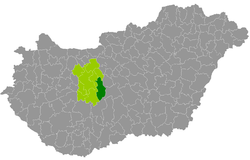
 Location of the district in Hungary |
|
| Basic data | |
| Country | Hungary |
| County | Fejér |
| Seat | Dunaújváros |
| surface | 650.1 km² |
| Residents | 89,818 (January 1, 2016) |
| density | 138 inhabitants per km² |
Dunaújváros (Hungarian Dunaújvárosi járás ) is a district in the southeast of the central Hungarian Fejér County . It borders in the northeast with Pest County , in the southeast with Bács-Kiskun County and in the south with Tolna County . Internally it is surrounded by the Martonvásár , Gárdony , Sárbogárd and Székesfehérvár districts ( Sárosd municipality , only approx. 2 km border).
history
The district emerged as the successor to the small area of the same name (Hungarian Dunaújvárosi kistérség ) with all 9 communities. That corresponded to 76.05% of the population on 42.8% of the area of the small area. The district was also enlarged by 7 of the 8 communities from the Adony small area to the north .
Community overview
The Dunaújváros County has an average municipality size of 5,614 inhabitants on an area of 40.63 square kilometers. The population density of the second most populous district is about one and a half times the county value. The administrative center is the largest city Dunaújváros , in the east of the district. The city has been treated as a county since the end of 1990 (Hungarian Megyei jogú város ).
| local community | status | Origin small area |
population | surface | Population density (inh / km²) |
||
|---|---|---|---|---|---|---|---|
| October 01, 2011 | 01/01/2013 | 01/01/2016 | |||||
| Adony | city | Adony | 3,717 | 3.714 | 3,686 | 61.05 | 60.4 |
| Baracs | local community | Dunaújváros | 3,419 | 3,360 | 3,383 | 55.18 | 61.3 |
| Beloiannisz | local community | Adony | 1,068 | 1,049 | 1,013 | 4.54 | 223.1 |
| Besnyő | local community | Adony | 1,752 | 1,737 | 1,693 | 44.64 | 37.9 |
| Daruszentmiklós | local community | Dunaújváros | 1,308 | 1,302 | 1,297 | 19.12 | 67.8 |
| Dunaújváros | city | Dunaújváros | 48,484 | 46,813 | 45.354 | 52.67 | 861.1 |
| Előszállás | Large community | Dunaújváros | 2,376 | 2,365 | 2,267 | 39.98 | 56.7 |
| Iváncsa | local community | Adony | 2,854 | 2,823 | 2,730 | 25.17 | 108.5 |
| Kisapostag | local community | Dunaújváros | 1,402 | 1,385 | 1,349 | 9.58 | 140.8 |
| Kulcs | local community | Adony | 2,662 | 2,665 | 2,724 | 16.73 | 162.8 |
| Mezőfalva | Large community | Dunaújváros | 4,721 | 4,720 | 4,697 | 80.42 | 58.4 |
| Nagykarácsony | local community | Dunaújváros | 1,348 | 1,333 | 1,296 | 30.46 | 42.5 |
| Nagyvenyim | local community | Dunaújváros | 4,874 | 4,096 | 4.034 | 43.68 | 92.4 |
| Perkáta | Large community | Adony | 3,911 | 3,987 | 3,887 | 74.52 | 52.2 |
| Pusztaszabolcs | city | Adony | 6,099 | 6,026 | 5,847 | 51.67 | 113.2 |
| Rácalmás | city | Dunaújváros | 4,419 | 4,479 | 4,561 | 40.64 | 112.2 |
| Dunaújváros district | 94.414 | 91,854 | 89,818 | 650.05 | 138.2 | ||
swell
PDF and XLS files: 2011
Census :
2013:; 2016:
Individual evidence
- ↑ KSH: 2011. Évi Népszámlálás. In: 3. Területi adatok. KSH, accessed on December 24, 2016 (Hungarian, also via: http://www.terezvaros.hu/testuleti/nepsz2011-3/pdf/nepsz2011_03_07.pdf ).
- ↑ KSH: Regional data - Fejér county. KSH, accessed on December 24, 2016 (English, 4th Data on Localities).
- ↑ KSH: Gazetteer of Hungary, 1st January, 2013. KSH, accessed on March 19, 2017 (Hungarian / English).
- ↑ KSH: Gazetteer of Hungary, 1st January, 2016. KSH, accessed on March 19, 2017 (Hungarian / English).