Sárbogárd district
| circle Sárbogárdi járás
Sárbogárd |
|
|---|---|
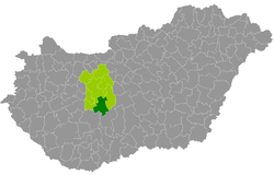
 Location of the district in Hungary |
|
| Basic data | |
| Country | Hungary |
| County | Fejér |
| Seat | Sárbogárd |
| surface | 653.5 km² |
| Residents | 27,578 (January 1, 2016) |
| density | 42 inhabitants per km² |
The district Sárbogárd (Hungarian Sárbogárdi járás ) is a district in the south of the central Hungarian Fejér county . It borders Tolna County in the south . Enying County forms the border to the west, Székesfehérvár County to the north and Dunaújváros County to the east .
history
The district was created in the course of the Hungarian administrative reform at the beginning of 2013 as the successor to the small area Sárbogárd (Hungarian Sárbogárdi kistérség ) with all 10 communities, supplemented by 2 communities from the small area Aba, which was dissolved at the end of 2012 . This increased the territory by 3,883 inhabitants (16%).
Community overview
The Mór district has an average municipality size of 2,298 inhabitants on an area of 54.46 square kilometers. The population density of the third smallest district is below that of the entire county. The administrative seat is the only town Sárbogárd , located in the center of the district.
| local community | status | Origin small area |
population | Area (km²) | Population density (inh / km²) |
||
|---|---|---|---|---|---|---|---|
| October 01, 2011 | 01/01/2013 | 01/01/2016 | |||||
| Alap | local community | Sárbogárd | 1.953 | 1,967 | 1,885 | 48.29 | 39.0 |
| Alsószentiván | local community | Sárbogárd | 645 | 658 | 624 | 39.65 | 15.7 |
| Cece | Large community | Sárbogárd | 2,598 | 2,589 | 2,570 | 58.85 | 43.7 |
| Hantos | local community | Sárbogárd | 956 | 962 | 951 | 36.96 | 25.7 |
| Igar | local community | Sárbogárd | 978 | 956 | 914 | 41.19 | 22.2 |
| Mezőszilas | local community | Sárbogárd | 2.116 | 2.140 | 2,069 | 64.97 | 31.8 |
| Nagylók | local community | Sárbogárd | 1,080 | 1,056 | 1,050 | 32.44 | 32.4 |
| Sárbogárd | city | Sárbogárd | 12,446 | 12,508 | 12,038 | 189.33 | 63.6 |
| Sáregres | local community | Sárbogárd | 731 | 737 | 733 | 26.16 | 28.0 |
| Sárkeresztúr | local community | Aba | 2,520 | 2,524 | 2,513 | 46.75 | 53.8 |
| Sárszentágota | local community | Aba | 1,332 | 1,359 | 1,319 | 45.50 | 29.0 |
| Vajta | local community | Sárbogárd | 941 | 1,053 | 912 | 23.43 | 38.9 |
| Sárbogárd district | 28,296 | 28,509 | 27,578 | 653.52 | 42.2 | ||
swell
PDF and XLS files: 2011
Census :
2013:; 2016:
Individual evidence
- ↑ KSH: 2011. Évi Népszámlálás. In: 3. Területi adatok. KSH, accessed on December 24, 2016 (Hungarian, also via: http://www.terezvaros.hu/testuleti/nepsz2011-3/pdf/nepsz2011_03_07.pdf ).
- ↑ KSH: Regional data - Fejér county. KSH, accessed on December 24, 2016 (English, 4th Data on Localities).
- ↑ KSH: Gazetteer of Hungary, 1st January, 2013. KSH, accessed on March 19, 2017 (Hungarian / English).
- ↑ KSH: Gazetteer of Hungary, 1st January, 2016. KSH, accessed on March 19, 2017 (Hungarian / English).