
Somogy county
  |
|
.svg)
|
|
| Somogy | |
| County seat : | Kaposvár |
| Surface: | 6,065 km² |
| Residents: | 309.115 as of 2016 |
Somogy [ ˈʃomoɟ ] (German Schomodei ) is a county (administrative district) in southwest Hungary . It borders with Croatia and the counties of Zala , Veszprém , Fejér , Tolna and Baranya . It has an area of 6065.06 km² and (beginning of 2016 ) 309,115 inhabitants. The county seat is Kaposvár .
geography
The area is mostly hilly. The southern border with Croatia is the Drava , which is the only river worth mentioning. In the north the county borders on Lake Balaton .
structure
With the government ordinance No. 218/2012 of August 13, 2012, the statistical small regions (Hungarian kistérség ) were abolished on January 1, 2013 and replaced by an approximately equal number of districts (Hungarian járás ). The small areas were retained for a while for planning and statistical purposes, but were finally abolished on February 25, 2014. There were eleven small areas in the county before it was dissolved. Four administrative units remained unchanged in their borders during the reform (Barcs, Csurgó, Nagyatád and Tab).

Former classification
By the end of 2012, the following 11 small areas existed in Somogy County:
| code | Small area | Administrative headquarters | Population (December 31, 2012) |
Area in km² |
Number of parishes |
including cities |
|---|---|---|---|---|---|---|
| 4401 | Barcs | Barcs | 23,817 | 696.47 | 26th | 1 |
| 4402 | Csurgó | Csurgó | 16.807 | 496.19 | 18th | 1 |
| 4403 | Fonyód | Fonyód | 23,616 | 372.82 | 11 | 3 |
| 4404 | Kaposvár | Kaposvár | 97.040 | 1041.14 | 54 | 2 |
| 4405 | Lengyeltóti | Lengyeltóti | 10,983 | 272.62 | 10 | 1 |
| 4406 | Marcali | Marcali | 35,301 | 922.5 | 38 | 1 |
| 4407 | Nagyatád | Nagyatád | 26,100 | 647.07 | 18th | 1 |
| 4408 | Siófok | Siófok | 39.091 | 386.11 | 11 | 2 |
| 4409 | tab | tab | 12,786 | 427.24 | 24 | 1 |
| 4410 | Balatonföldvár | Balatonföldvár | 11,475 | 241.73 | 13 | 1 |
| 4411 | Kadarkút | Kadarkút | 19,885 | 531.96 | 23 | 2 |
Current classification
Somogy county is divided into 8 districts (Hungarian járás ) with 246 villages:
the city of Kaposvár with county law (Hungarian Megyei jogú város ), 15 cities without county law (Hungarian város ), 2 large municipalities (Hungarian nagyközség ) and 228 municipalities (Hungarian község ) .
| Location type | number | Area (in km²) | Population on January 1, 2016 | Population density (Ew / km²) |
||||
|---|---|---|---|---|---|---|---|---|
| absolutely | proportionally | on average | absolutely | proportionally | on average | |||
| City with county law | 1 | 113.59 | 1.87% | 63.186 | 20.44% | 556.3 | ||
| Cities without county law | 15th | 920.56 | 15.18% | 61.37 | 97,346 | 31.49% | 6,489.73 | 105.7 |
| Large municipalities | 2 | 83.89 | 1.38% | 41.95 | 4,510 | 1.46% | 2,255.00 | 53.8 |
| Communities | 228 | 4,947.02 | 81.57% | 21.70 | 144.073 | 46.61% | 631.90 | 29.1 |
| Somogy county as a whole | 246 | 6,065.06 | 24.65 | 309.115 | 1,256.57 | 51.0 | ||
The current circles are:
| code | circle | Circular seat | Residents (January 1, 2013) |
Area in km² |
Number of parishes |
including cities |
|---|---|---|---|---|---|---|
| 140 | Barcs | Barcs | 23,817 | 696.47 | 26th | 1 |
| 141 | Csurgó | Csurgó | 16.807 | 496.19 | 18th | 1 |
| 142 | Fonyód | Fonyód | 34,599 | 645.44 | 21st | 4th |
| 143 | Kaposvár | Kaposvár | 117,492 | 1591.36 | 78 | 4th |
| 144 | Marcali | Marcali | 34,734 | 904.24 | 37 | 1 |
| 145 | Nagyatád | Nagyatád | 26,100 | 647.07 | 18th | 1 |
| 146 | Siófok | Siófok | 51,761 | 657.05 | 24 | 3 |
| 147 | tab | tab | 12,786 | 427.24 | 24 | 1 |
At the beginning of 2013, the village of Balatonvilágos moved from the small area Balatonalmádi in Veszprém County to Siófok County in Somogy County.
Largest cities and towns
| city | Residents (January 1, 2016) |
|---|---|
| Kaposvár 1 | 63.186 |
| Siófok 1 | 25,364 |
| Marcali 1 | 11,352 |
| Barcs 1 | 10,698 |
| Nagyatád 1 | 10,468 |
| Balatonboglár 1 | 5,673 |
| Balatonlelle 1 | 5,235 |
| Csurgó 1 | 4,932 |
| Fonyód 1 | 4,745 |
| Tab 1 | 4,301 |
| Nagybajom 1 | 3,309 |
| city | Residents (January 1, 2016) |
|---|---|
| Lengyeltóti 1 | 2,952 |
| Balatonszabadi 2 | 2,951 |
| Berzence 3 | 2,549 |
| Segesd 2 | 2,453 |
| Kaposmérő 2 | 2,427 |
| Zamardi 1 | 2,422 |
| Kadarkút 1 | 2,418 |
| Kéthely 2 | 2,280 |
| Böhönye 2 | 2,254 |
| Balatonföldvár 1 | 2,150 |
| Ádánd 2 | 2.112 |
1 city ( város )
2 municipality ( köszég )
3 large municipality ( nagyköszeg )

Kereki - castle
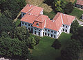
Aerial photo: Nagyberki Palace

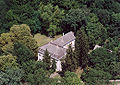
Aerial view: Iharosberény Palace
Aerial view: Babócsa Castle

Former castle in Barcs

Csurgó - high school


Population development
Population development of the county
Dates in bold are census results.
| date | population | date | population |
|---|---|---|---|
| 01/01/1960 1 | 368.183 | 01/01/2007 | 329.722 |
| 01/01/1970 | 357.009 | 01/01/2008 | 326.238 |
| 01/01/1980 | 360.270 | 01/01/2009 | 323,389 |
| 01/01/1990 | 344,708 | 01/01/2010 | 321.764 |
| 01/01/2001 | 339.142 | 01/01/2011 | 319.120 |
| 02/01/2001 | 335.237 | October 01, 2011 | 316.137 |
| 01/01/2002 | 337.992 | 01/01/2012 | 320.006 |
| 01/01/2003 | 336.905 | 01/01/2013 | 318.096 |
| 01/01/2004 | 335.282 | 01/01/2014 | 315,512 |
| 01/01/2005 | 333.017 | 01/01/2015 | 312.084 |
| 01/01/2006 | 330,634 | 01/01/2016 | 309.115 |
1 1960: present population; otherwise resident population
Population development of the districts
A negative population balance can be seen for all districts.
| District name | Population level on January 1st | |||
|---|---|---|---|---|
| 2013 | 2014 | 2015 | 2016 | |
| Barcs | 23,817 | 23,596 | 23,262 | 22,868 |
| Csurgó | 16.807 | 16,485 | 16,377 | 16.199 |
| Fonyód | 34,599 | 34,222 | 33,935 | 33,593 |
| Kaposvár | 117,492 | 116,547 | 115.017 | 113,886 |
| Marcali | 34,734 | 34,620 | 34,085 | 33,750 |
| Nagyatád | 26,100 | 25,833 | 25,542 | 25,282 |
| Siófok | 51,761 | 51,544 | 51,369 | 51,222 |
| tab | 12,786 | 12,665 | 12,497 | 12,315 |
| Somogy county | 318.096 | 315,512 | 312.084 | 309.115 |
History and culture
Museums
The Somogy County Museum Directorate is responsible for four county museums . The county seat is the town of Kaposvár .
|
|
|
* County Museum
Web links
- Somogy County Self-Government (Hungarian)
Individual evidence
- ^ Detailed Gazetteer of Hungary
- ↑ Gazetteer of Hungary, 1st January, 2013 (Hungarian / English)
- ↑ KSH: Gazetteer of Hungary, 1st January, 2016. In: Minden helység adata. KSH, accessed on March 7, 2017 (Hungarian / English, also PDF file).
- ↑ a b 6.1.1. Resident population by sex, January 1st (2001-) (STADAT table). KSH, accessed February 17, 2017 .
- ↑ Directorate of Museums of Somogy County SMMI (Somogy Megyei Múzeumok Igazgatósága)
Bács-Kiskun | Baranya | Békés | Borsod-Abaúj-Zemplén | Budapest | Csongrád-Csanád | Fejér | Győr-Moson-Sopron | Hajdú-Bihar | Heves | Jász-Nagykun-Szolnok | Komárom-Esztergom | Nógrád | Plague | Somogy | Szabolcs-Szatmár-Bereg | Tolna | Vas | Veszprém | Zala
Coordinates: 46 ° 25 ' N , 17 ° 35' E