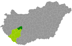
Siófok district
| circle Siófoki járás
Siófok |
|
|---|---|
 Location of the district in Hungary |
|
| Basic data | |
| Country | Hungary |
| County | Somogy |
| Seat | Siófok |
| surface | 657.1 km² |
| Residents | 51,222 (January 1, 2016) |
| density | 78 inhabitants per km² |
The Siófok County ( Hungarian Siófok járás ) is a district in the northeast of the southwestern Hungarian Somogy County . It borders Fonyód County in the west , Tab County in the south, Tamási County ( Tolna County ) in the southeast and Enying County ( Fejér County ) in the east . The border in the north and north-west of the Veszprém county runs across Lake Balaton ( Hungarian: Balaton ).
history
The district existed between 1950 and 1983 and was re-established for the Hungarian administrative reform. On January 1, 2013 it emerged as the successor to the small area of the same name ( Hungarian Siófoki kistérség ), which still includes all 13 municipalities from the western small area Balatonföldvár ( Hungarian Balatonföldvári kistérség ) and the municipality of Balatonvilázprémitat from the county of Veszprémitat, which was also dissolved at the end of 2012 was expanded. The Siófok district currently comprises 24 municipalities, 3 of which have municipal rights.
Community overview
The Siófok District has an average municipality size of 2,134 inhabitants on an area of 27.38 square kilometers. The population density of the second most populous district is above the county value. The district seat is located in the largest city, Siófok , almost in the middle of the circle.
| 24 municipalities | status | Origin small area |
population | Area (km²) | Population density (inh / km²) |
||
|---|---|---|---|---|---|---|---|
| October 01, 2011 | 01/01/2013 | 01/01/2016 | |||||
| Ádánd | local community | Siófok | 2.121 | 2.124 | 2.112 | 29.52 | 71.5 |
| Balatonendréd | local community | Siófok | 1,356 | 1,330 | 1,297 | 40.02 | 32.4 |
| Balatonföldvár | city | Balatonföldvár | 2,207 | 2,235 | 2,150 | 15.32 | 140.3 |
| Balatonőszöd | local community | Balatonföldvár | 487 | 507 | 479 | 15.08 | 31.8 |
| Balatonszabadi | local community | Siófok | 2,971 | 2,994 | 2,951 | 41.34 | 71.4 |
| Balatonszárszó | Large community | Balatonföldvár | 1,900 | 1.965 | 1.961 | 30.13 | 65.1 |
| Balaton zemes | local community | Balatonföldvár | 1,817 | 1,827 | 1,743 | 36.02 | 48.4 |
| Balatonvilágos | local community | Balatonalmádi | * 1 | 1,195 | 1,158 | 29.21 | 39.6 |
| Bálványos | local community | Balatonföldvár | 547 | 544 | 539 | 23.69 | 22.8 |
| Kereki | local community | Balatonföldvár | 546 | 556 | 532 | 14.43 | 36.9 |
| Koröshegy | local community | Balatonföldvár | 1,392 | 1,329 | 1,355 | 21.39 | 63.3 |
| Poo | local community | Balatonföldvár | 453 | 481 | 500 | 19.54 | 25.6 |
| Nagyberény | local community | Siófok | 1,323 | 1,330 | 1,292 | 23.14 | 55.8 |
| Nagycsepely | local community | Balatonföldvár | 353 | 386 | 410 | 19.80 | 20.7 |
| Nyim | local community | Siófok | 286 | 270 | 297 | 9.76 | 30.4 |
| Pusztaszemes | local community | Balatonföldvár | 339 | 343 | 338 | 10.39 | 32.5 |
| Ságvár | local community | Siófok | 1,830 | 1,830 | 1,773 | 38.44 | 46.1 |
| Siófok | city | Siófok | 25,045 | 25,441 | 25,364 | 124.66 | 203.5 |
| Siójut | local community | Siófok | 616 | 620 | 621 | 10.73 | 57.9 |
| Som | local community | Siófok | 707 | 701 | 666 | 23.35 | 28.5 |
| Szántód | local community | Balatonföldvár | 560 | 592 | 579 | 7.91 | 73.2 |
| Szólád | local community | Balatonföldvár | 489 | 501 | 480 | 19.98 | 24.0 |
| Teleki | local community | Balatonföldvár | 198 | 209 | 203 | 8.05 | 25.2 |
| Zamardi | city | Siófok | 2,386 | 2,451 | 2,422 | 45.15 | 53.6 |
| Siófok district | 49,929 | 51,761 | 51,222 | 657.05 | 78.0 | ||
1 Population data see Balatonalmádi district
swell
PDF and XLS files: 2011
Census :
2013:; 2016:
Individual evidence
- ↑ KSH: 2011. Évi Népszámlálás. In: 3. Területi adatok. KSH, accessed on December 26, 2016 (Hungarian, also via: http://www.terezvaros.hu/testuleti/nepsz2011-3/pdf/nepsz2011_03_14.pdf ).
- ↑ KSH: Regional data - Somogy county. KSH, accessed December 30, 2016 (English, 4th Data on Localities).
- ↑ KSH: Gazetteer of Hungary, 1st January, 2013. KSH, accessed on April 4, 2017 (Hungarian / English).
- ↑ KSH: Gazetteer of Hungary, 1st January, 2016. KSH, accessed April 4, 2017 (Hungarian / English).
Coordinates: 46 ° 55 ' N , 18 ° 5' E