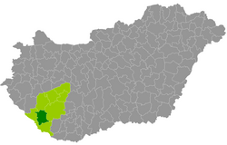
Nagyatád County
| circle Nagyatádi járás
Nagyatád |
|
|---|---|
 Location of the district in Hungary |
|
| Basic data | |
| Country | Hungary |
| County | Somogy |
| Seat | Nagyatád |
| surface | 647.1 km² |
| Residents | 25,282 (January 1, 2016) |
| density | 39 inhabitants per km² |
The district Nagyatád (Hungarian Nagyatádi járás ) is a landlocked county in the center of the south-west Hungarian Somogy County . It borders on the Csurgó County to the west , Marcali County to the north, Kaposvár County to the east and Barcs County to the south .
history
During the Hungarian administrative reform in early 2013, the district emerged unchanged with all 18 municipalities as the successors of the small area of the same name (Hungarian Nagyatádi kistérség ).
Community overview
Nagyatád County has an average parish size of 1,405 inhabitants in an area of 35.95 square kilometers. The population density is below the county value. The district seat is located in the only city, Nagyatád , in the center of the district.
| Communities | status | Origin small area |
population | Area (km²) | Population density (inh / km²) |
||
|---|---|---|---|---|---|---|---|
| October 01, 2011 | 01/01/2013 | 01/01/2016 | |||||
| Bakháza | local community | Nagyatád | 180 | 191 | 179 | 5.92 | 30.2 |
| receipt | local community | Nagyatád | 631 | 592 | 599 | 17.99 | 33.3 |
| Bolhás | local community | Nagyatád | 412 | 436 | 418 | 31.43 | 13.3 |
| Görgeteg | local community | Nagyatád | 1,091 | 1,111 | 1,135 | 33.50 | 33.9 |
| Háromfa | local community | Nagyatád | 789 | 788 | 759 | 42.14 | 18.0 |
| Kaszó | local community | Nagyatád | 105 | 110 | 96 | 22.48 | 4.3 |
| Kisbayom | local community | Nagyatád | 417 | 417 | 394 | 13.67 | 28.8 |
| Kutas | local community | Nagyatád | 1,412 | 1,456 | 1,479 | 36.55 | 40.5 |
| Lábod | local community | Nagyatád | 1,964 | 2,048 | 1.914 | 66.51 | 28.8 |
| Nagyatád | city | Nagyatád | 11,032 | 10,921 | 10,468 | 70.60 | 148.3 |
| Nagykorpád | local community | Nagyatád | 598 | 608 | 575 | 33.42 | 17.2 |
| Ötvöskónyi | local community | Nagyatád | 951 | 925 | 922 | 27.71 | 33.3 |
| Rinyabesenyő | local community | Nagyatád | 192 | 209 | 222 | 28.63 | 7.8 |
| Rinyaszentkirály | local community | Nagyatád | 390 | 394 | 373 | 30.56 | 12.2 |
| Segesd | local community | Nagyatád | 2,483 | 2,528 | 2,453 | 73.09 | 33.6 |
| Somogyszob | local community | Nagyatád | 1,573 | 1,586 | 1,530 | 40.08 | 38.2 |
| Szabás | local community | Nagyatád | 604 | 597 | 601 | 18.11 | 33.2 |
| Tarany | local community | Nagyatád | 1,179 | 1,183 | 1,165 | 54.68 | 21.3 |
| Nagyatád County | 26.003 | 26,100 | 25,282 | 647.07 | 39.1 | ||
swell
PDF and XLS files: 2011
Census :
2013:; 2016:
Individual evidence
- ↑ KSH: 2011. Évi Népszámlálás. In: 3. Területi adatok. KSH, accessed on December 26, 2016 (Hungarian, also via: http://www.terezvaros.hu/testuleti/nepsz2011-3/pdf/nepsz2011_03_14.pdf ).
- ↑ KSH: Regional data - Somogy county. KSH, accessed December 30, 2016 (English, 4th Data on Localities).
- ↑ KSH: Gazetteer of Hungary, 1st January, 2013. KSH, accessed on April 4, 2017 (Hungarian / English).
- ↑ KSH: Gazetteer of Hungary, 1st January, 2016. KSH, accessed April 4, 2017 (Hungarian / English).