Circle tab
| circle Tabi járás
tab |
|
|---|---|
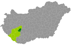
 Location of the district in Hungary |
|
| Basic data | |
| Country | Hungary |
| County | Somogy |
| Seat | tab |
| surface | 427.2 km² |
| Residents | 12,315 (January 1, 2016) |
| density | 29 inhabitants per km² |
The Tab district (Hungarian Tabi járás ) is a district in the east of Somogy County in southwest Hungary . It borders on Kaposvár County to the south, Fonyód County to the west and Siófok County to the north . The county Tamási from Tolna county forms the border in the east.
history
The district emerged unchanged from the Hungarian administrative reform at the beginning of 2013 with all 24 municipalities from the small area of the same name (Hungarian Tabi kistérség ).
Community overview
The Tab district has an average municipality size of 513 inhabitants on an area of 17.80 square kilometers. The district is last in the county with area, population and population density . The population density of the district is second to last of all 174 Hungarian districts.
The administrative center is in the only town, Tab , in the north of the district.
| local community | status | Origin small area |
population | Area (km²) | Population density (inh / km²) |
||
|---|---|---|---|---|---|---|---|
| October 01, 2011 | 01/01/2013 | 01/01/2016 | |||||
| Andocs | local community | tab | 1,068 | 1.110 | 1,076 | 43.27 | 24.9 |
| Bábonymegyer | local community | tab | 846 | 816 | 793 | 21.93 | 36.2 |
| Bedegkér | local community | tab | 437 | 430 | 394 | 26.00 | 15.2 |
| Bonnya | local community | tab | 257 | 251 | 237 | 14.62 | 16.2 |
| Fiad | local community | tab | 146 | 138 | 127 | 14.91 | 8.5 |
| Kanya | local community | tab | 414 | 422 | 411 | 14.52 | 28.3 |
| Kapoly | local community | tab | 667 | 670 | 679 | 22.37 | 30.4 |
| Kára | local community | tab | 46 | 47 | 45 | 5.37 | 8.4 |
| Kisbárapáti | local community | tab | 401 | 418 | 365 | 28.71 | 12.7 |
| Lulla | local community | tab | 188 | 175 | 178 | 10.39 | 17.1 |
| Miklósi | local community | tab | 209 | 220 | 203 | 10.47 | 19.4 |
| Nágocs | local community | tab | 678 | 656 | 660 | 22.26 | 29.6 |
| Sérsekszőlős | local community | tab | 148 | 154 | 145 | 6.65 | 21.8 |
| Somogyacsa | local community | tab | 156 | 174 | 172 | 24.46 | 7.0 |
| Somogydöröcske | local community | tab | 124 | 132 | 131 | 10.83 | 12.1 |
| Somogyegres | local community | tab | 183 | 214 | 164 | 10.81 | 15.2 |
| Somogymeggyes | local community | tab | 486 | 497 | 490 | 15.65 | 31.3 |
| Szorosad | local community | tab | 105 | 106 | 95 | 6.48 | 14.7 |
| tab | city | tab | 4,533 | 4,430 | 4,301 | 25.86 | 166.3 |
| Tengőd | local community | tab | 462 | 447 | 417 | 30.21 | 13.8 |
| Törökkoppány | local community | tab | 410 | 428 | 425 | 25.80 | 16.5 |
| Torvaj | local community | tab | 247 | 245 | 244 | 11.42 | 21.4 |
| Zala | local community | tab | 238 | 245 | 237 | 9.24 | 25.6 |
| Zics | local community | tab | 348 | 361 | 326 | 15.01 | 21.7 |
| Circle tab | 12,797 | 12,786 | 12,315 | 427.24 | 28.8 | ||
Individual evidence
- ↑ KSH: 2011. Évi Népszámlálás. In: 3. Területi adatok. KSH, accessed on December 26, 2016 (Hungarian, also via: http://www.terezvaros.hu/testuleti/nepsz2011-3/pdf/nepsz2011_03_14.pdf ).
- ↑ KSH: Regional data - Somogy county. KSH, accessed December 30, 2016 (English, 4th Data on Localities).
- ↑ KSH: Gazetteer of Hungary, 1st January, 2013. KSH, accessed on April 4, 2017 (Hungarian / English).
- ↑ KSH: Gazetteer of Hungary, 1st January, 2016. KSH, accessed April 4, 2017 (Hungarian / English).